2020 01 30 Lake Ginninderra Social Walk with MelbaShed
This was a 6.4 Km circular walk around Lake Ginninderra taking 2hrs 16mins with a break at Birrigai Cafe at the Kangara Waters retirement village. This walk encapsulated several short cuts not used by the normal mobs, such as walking up and over Diddams Hill. This was Melba Shed walk No 224 on 30th Jan 2020.
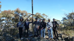
Featured image – Greg and the guys on Diddams Hill which overlooks Belconnen Town Centre. Yes there was some bushfire smoke lingering around
I led this walk with 5 walking. 5 of us met at the Shed by 8.00AM & drove to the car park next to Lake Ginninderra on the east side of Diddams Close. Then from 8.16AM we walked anti-clockwise around the lake.
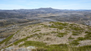
We took a short cut through open grasslands across the peninsula & up a hill we knew as Diddams Hill, then coming down on its north west side finding a hole dug into the ground around which was some rubbish & old pallets.

We then continued right around the lake taking some shortcuts on dirt pads other walkers had made, until we eventually came past the town centre. On the bridge across the south end we could see a lot of rubbish & dirty water in a new series of ponds built by the local Government to contain such rubbish. Whether this has worked is unclear but a lot of dirty water is sitting just next to the bridge.
We then stopped at Birrigai Cafe in the IRT Kangara Waters retirement village. Here we partook of coffee & of course a couple of strawberry milkshakes in some strange containers. The grin on their faces indicated they were satisfied.
We then returned to the cars 10.30AM. The weather was warm & fine with a covering of smoke blocking part of the sun.
It was an Easy-Medium social walk of 6.4Km taking 2hrs 16m incl breaks.
Walkers: Bob Salmond, David Ruthven, Harry Angel, Drew McDonald, Greg Hutchison
Map of walk | More pictures in Google Photos | files including gps located in Google Drive
Notes re Map: GPS map views provided using Garmin Basecamp with map base from OSM an open source service | The area of the walk is covered by the NSW 1:25,000 topo map CANBERRA