
2018 07 24 Mt Gulaga
This walk on 24th July 2018 was organised by Drew. He wanted to do it for a long time. We walked from Tilba Tilba to Mt Gulaga (was called Mt Dromedary) on an old 4WD that was built for mining and timber getting. We also visited an important aboriginal location known as The Cathedral
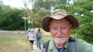
Featured image is of Greg on the Saddle Trail in Rainforest
This was a planned walk that Drew and I did. We read a few reviews of the walk and learned that Mt Dromedary was now called Mt Gulaga in Gulaga National Park. It seemed to be a walk that many people decided that they must do. Drew thought if he didn’t do it now he never would.
We started in Canberra on Monday 23rd July about 2.30PM and drove down the Kings Highway to Batemans Bay and thence to Tuross Heads where we stayed at Drew’s holiday house, reaching there around 5PM. I was surprised by Tuross Heads. Its a nice compact yet substantial town with nice views of the ocean as a lot of the area is hilly. It has it own services through a small shopping centre and doctors surgery. It has two caravan parks, a couple of nice beaches and nice area along the Tuross River as it exits to the sea. It also has an active community group that ensures services and development are compatible with the area. It has adequate mobile phone coverage and they have now rolled out NBN FTTN. The other key element is that its a holiday town so quiet over most of the year. Its also not extremely hot nor cold. However on the night of the 23rd it was quite cold.
We got up early but enjoyed an unrushed breakfast before setting off to drive further south past Narooma, where we then went past the Central Tilba turnoff, then turned right onto Corkhill Drive and reached Tilba Tilba, a small quaint village just of the Princes Highway.
We parked at a small grassy area on the North West side of the intersection of The Avenue and Corkhill Drive and opposite where Pam’s Store is located. Please note that parking near Pams Store is no longer available. The walk now starts at Tilba Rugby Field where there is free all day parking with public toilets available.
We started our walk here leaving around 9.11AM and just carrying day packs with around a litre of water each plus a 420ml flask of hot coffee, and sandwiches for lunch. We both had on jumpers, Drew with a tee shirt underneath, me with a tea shirt & flannelette shirt
As you turn into The Avenue, (note its marked as the Mt Dromedary Walking Trail) there is a toilet on the left provided by Pams Store which the public can use, then a Nursery which a lot of local plants for sale. Then we went past a farm on the left Mountain View Farm that has well manicured gardens and offers farm stay cottages for rent. It looks like a lovely place and its web site offers some local information.
After that it was a lovely walk for 500-700m with picturesque views across to the north and south as we walked. Then the road started to rise until at around 1.1km from the start a sign said no more vehicles and the last house was passed on the right. Then there was a fantastic view across to the south east of the amazing Little Mt Dromedary peak. The track now climbed continually until after 1.5Km from the start we passed a National Park gate saying we were now in Gulaga National Park. Just after the gate we took a sharp turn to the south before again turning sharply to the north west before the track flattened out a little, although continuing to climb. We stopped near there and took off our jumpers. As we walked up it was quite chilly but the climbing kept us warm.
As we climbed we started to notice a change in vegetation with ferns and a more rainforest canopy starting to occur. Part way up we came across an old Geology marker that had some information about the geology of the area. It was marked as Stop 4. It had a strange rock nearby. Soon after we came across Halfway Rock. Near here was supposed to be the turnoff for the Battery Track which led to an old mining site. We looked on the way up and down and could not definitively find it, although I have marked a spot where I believe it must be. Most of the rest of the trip the drop off next to the trail was too steep for any possible side track.
We reached the saddle where there is a picnic table, a toilet and it seems like a nice spot to stop for a break. Also its a junction where the Old Dromedary Trail (shown on the map there as the North Track) comes from the north and the Summit-Rainforest Trail heads south to reach the summit. Its also where a rough track to the Cathedral leaves. We were not sure but its likely that the old more direct summit trail leaves from here. However when we got here at 11.00AM we were surprised to see a dozen cars parked everywhere and groups of people, around 20 were being told stories and educated on the local aboriginal i.e. the Yuins’ culture and I think the importance of Mt Gulaga. So we didn’t stay long and headed off around 11.12AM after having some of Drew’s orange and water. It had been so cool on the way up I had hardly drunk any water.
After about 550m from the saddle the track reaches a crest and then descends slowly. On the way there was a Rainforest sign and a small footpad went off to the left (i.e. east) to a group of small vertical rocks which one blogger had called the Tors. So we stopped and checked them. Returning to the main trail we continued down the trail until the track did a sharp turn right and then went uphill until the top. Where we turned there was a barrier across the trail. Originally the trail went straight ahead for 300-400m and joined the Saunders Trail which went up to the top of the ridge and across to a further western peak of Mt Gulaga. We didn’t go along it as it seems overgrown.
It was then a steep foot trail obviously built for walkers only. The trail then zigged & zagged for around 450m always uphill until we reached the peak around 12PM. The peak was topped with a large cairn with an old trig on top. This part of the walk had some of best rainforest along the whole trip. I had got there slightly later than Drew as near the top there was a junction and I took the other one which seemed to go down and I assumed it was the original Summit Track.
We spent 35mins at the top, having lunch, mandarins and also partaking of some flask coffee. We were also intrigued by this very small dark coloured bird that flittered around us. It was impossible to photo as it would not stay still. I also walked behind the trig and found that there was a feint foot pad that wound it way west and which I assumed continued along the ridge line to join the Saunders Track in 500m before continuing to the other 806m peak 1.6km to the west. Views from the top were very constrained due to strong tree growth. The best views from the top we found were along the trail around 300m or so south of the Saddle location.

We headed down the same way stopping at the Saddle and asking the local aboriginal guide if she knew of the Cathedral. I think she was reluctant to tell us however she pointed the way south east behind the table and it turned out to be the right call. In around 100m or so we could see through the trees some majestic rocks standing tall amongst the trees with one in particular perched precariously on another rock below. The rocks in various shapes, some quite tall seemed to span for a couple of hundred metres along the ridge line heading roughly east. I was just about to stop and suggest we had had enough when I got my foot caught under a branch on the ground and I crashed to the ground, landing on my left elbow and also hands. I was OK but had multiple small scratches on my hands and a pain near my left elbow. Drew helped me by putting a couple of bandaids on the worst bleeders. It wasn’t until I got home and had a shower that I realised I had a large wound just below my left elbow. However by that time it had scabbed over and never had bled that much, although it hurt all the way back.
By the time we got back to the Saddle the others had left so we headed back to the car reaching there around 3.11PM. All was well, although I couldn’t find my house keys. Bugger! On the way home, we went back into Tuross to look for my keys. Of course on the 4th check of my day pack after failing to find them there, I found them hidden in the bottom of the day pack underneath my emergency medical kit. I think there is some irony in that!
We headed home stopping in Batemans Bay at Maccas for a coffee and McMuffin, as well as getting petrol at Costco Majura Park. The drive back was uneventful in the dark as the traffic was quite low. I dropped off Drew first and then got home myself at 7.45PM having done around 535km return.
Track Distance and Times
We had walked 14.4Km, having started 9.11AM and finished 3.11PM, i.e. 6hrs. Other in reviews said it took from 4-5 hrs. Yes you could do it quicker but it’s worth taking it more slowly to absorb the tranquillity and beauty of the rainforest as well as visiting the Tors and The Cathedral. We saw distances from 12.6 to 16Km being advised. Leaving off our detours to the Tors and the Cathedral would have reduced the trip to 13.5Km.
The Early Days
Captain Cook sailed past this area on 22nd January 1770 and was the first place named by him in Australia. He named the peak Mt Dromedary.
In the story of the Yuin, Cheryl Davidson says “This story’s about Gulaga, Gulaga mountain which is on the South Coast. It’s a very significant Aboriginal site. This is a story that was told to me by my family and my grandfather, Reggie Walker. My grandfather was a fisherman, he’d row his boat right out to sea and he’d tell us “When you’re out there it just looks like a lady, laying down.”” I must admit I also thought the view of the mountain from the sea looked the same to me.
Indigenous Information
Some links with information about the and their traditions and customs
This is from a women who went on a tour
Cheryl tells the story of Gulaga
Near the Saddle (and a little hidden from the main track) is the beautiful ‘Cathedral’. The cathedral has a bunch of massive banatite tors which are up to 30 m high. The Cathedral is a very sacred place to the Yuin people. For the Yuin people, Gulaga symbolises the mother and provides a basis for Aboriginal spiritual identity.
Gulaga Mountain Creation Tour – Diverse
Gulaga Creation Tour – Cursons
Gulaga Creation Tour -Ngaranaboriginalculture
Mining Information
About mining heritage and geology
Other Reviews
Map extracts, gps files, photos
Map of walk topo | Map of walk Oztopo | More pictures in Google Photos | Google Earth GPS file | Gpx file
Notes: GPS map views on map base using Oztopo &/or Ozraster Maps with permission of © BKK Enterprises Pty Ltd, http://www.gpsoz.com.au | gps, gpx and GE files are located in Google Drive


Thanks for the link. Nice trip report – very detailed!
Update Gulaga Mountain Walk information please
I am writing you in regard to the information on your website about parking at Pam’s Store car park for bush walkers.
Your information is no longer correct and could you kindly update this information to state that the walk starts at Tilba Rugby Field where there is free all day parking with public toilets available.
Feel free to contact me on 0402171450 or email me at pamstoretilba@gmail.com
Kind regards,
Sarah Fisse
Store owner
Pam’s Store Tilba Tilba