2019 07 18 Mt Ainslie & Majura Dams with MelbaShed
This was a 7.7Km walk taking 2hrs 45 mins for an interesting walk between the Majura Dams and the ridgeline between Mt Majura and Mt Ainslie mixed with a mountain bike track between Hackett Car park and the Majura Dams, in Canberra, Australia. This was Melba Shed walk No 209.
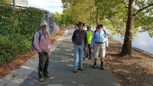
Featured image is of Greg on the MTB Trail between Hancocks Rd & the Blue Metal Track
I led this walk with 5 walking on a cool winter’s day.
4 of us met at the Shed by 8.30AM & drove to a car park on Kellaway St, Hackett. Here we met one more.
Then from 9AM we walked a short distance up Hancocks Rd before turning left or north-east for 1.1km along a nice dirt MTB trail before reaching the Blue Metal Trail.
We then walked 220m along the trail to a notice board. Interesting that it had a short section about the Stone Wall & fence line north-west of Mt Majura. We then turned left for 100m to read a sign about the Majura Dams, then going around the Lower Dam to its north & then north-east for 150m to view the Upper Dam.

Then we continued up a well worn path for another 300m before we could turn right & proceed through open country for 150m until we regained the Blue Metal Trail & were soon at the gate to the Majura Pines Area.
We then turned south & south-west for around 1.8km following the Cherryburn or Old TSR Tk along the high ridge between Majura & Ainslie We were now at a major junction for Hancocks Rd, the Eastern Powerline Trail, the trail we were on and another footpad that followed another powerline down towards the main western Powerline. Then we took another footpad down under the powerline & then turned south, climbing up through a she-oak forest until we reached the Old Tip to Summit FT in 600m.
Then it was up to the 5 Ways in 350m. Then we took the CCT towards the top for 500m, & then turned off down a steep track for 400m stopping for a short rest.
We then joined a nice track that was fairly flat back north for 250m through another she-oak forest to reach another track that goes from the 5-Ways down to meet the Western Powerline Track in 375m. Then it was an easy walk along this track for 240m to the bottom of the Old Tip to Summit Trail where we turned North-East to follow a vague easy footpad for 500m back to the gate & cars by 11.45AM.
This was a Medium walk with some climbing overall from 620m at the start to a max height of 710m. 4 of us then went to the Knox Cafe in Watson for coffees & Bobs expensive milk shake.
We had started walking at 9AM and finished at 11.45AM, ie 2hrs 45m.
Walkers: Bob Salmond, Colin Fitzpatrick, Paul Taylor, Drew McDonald, Greg Hutchison | Drivers: Paul T & Drew
References: Fairly common around the tops of Mt Ainslie & Majura are the drooping she-oaks or drooping sheoak forest (allocasuarina verticillata). Reference: “Trees and Shrubs of Black Mountain, Mt. Ainslie and Mt. Majura – A Key Based On Vegetative Characteristics” Laurence G. Adams
Map of walk | More detailed map around Dams | More pictures in Google Photos | files including gps located in Google Drive
Notes re Maps: GPS map views provided using Garmin Mapsource with map base using OSM | The area of the walk is covered by the NSW 1:25,000 topo map CANBERRA. Mt Ainslie and Majura have a large number of foot tracks not shown on official maps. These can be better seen on OSM on the web