Kosciuszko National Park – 4-6 Apr 2025 – Arsenic Ridge Track – Brooks Hut to Tabletop Track
This was the third trip by the same group to survey and document the best route to enable the recreation of the Arsenic Ridge Trail between Happy Jacks Road and the Table Top Trail just east of Tabletop Mountain.
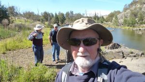
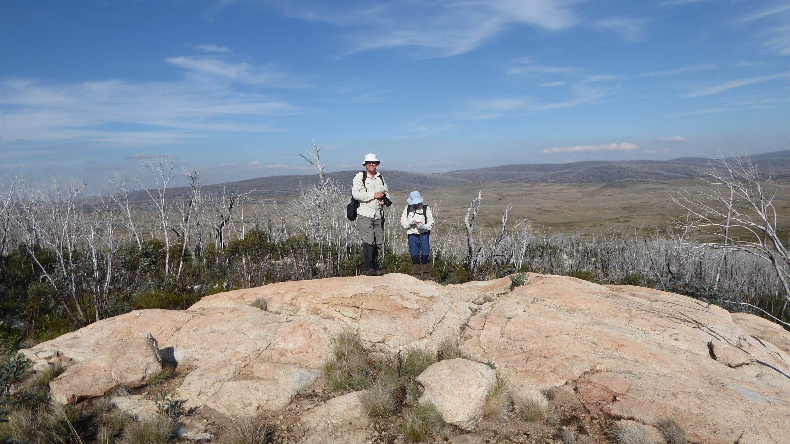
The featured image shows 2 of the walkers on the rocky lookout one would pass on this walking route with views to Happy Jacks Valley and way out to Mount Jagungal. They were Mika at the front with Stephen Joske behind.
Introduction
Originally the Arsenic Ridge trail was a rough route that gold miners took on their journey from the Victorian Goldfields to the Kiandra in the late 1800’s. Later the Snowy Mountains Authority built a better vehicle trail over much of the same route known by many as Ligars Route.
In late 2024 a small group of us got together in Canberra to organise a final trip to KNP to definitely survey the required route especially as the work we had achieved on two previous occasions had been significantly damage by bushfires that roared through the country around the route. That fire damaged many huts in and near Kiandra and the Snowy Mountains Highway as well taking out Brooks Hut. However, over the preceding couple of years NPWS had done amazing work restoring most of these huts including the well know 4 Mile Hut. In 2024 they finished restoring Happys Hut and also Brooks Hut, the latter having been a key site in the Arsenic Ridge route.
In late 2024 we had been contacted by the NPWS Tumut branch to define our required survey date as well as getting all the proposed members of the volunteer group to become registered in the NPWS volunteer database. We also had to have three members with registered first aid certificates but with some having to get their old certificates re-registered we were able to get 4 people together 3 with first aid certificates.
We also were given permission to drive vehicles to Brooks Hut and up the Tabletop Trail to near Tabletop Mountain. This meant we didn’t have to back pack to the sites and allowed us to complete most of the ground survey in just over two days.
Day 1 Friday 4th April


Day 1 didn’t quite go as planned but we were able to pick up the leader from his place of living around 9AM and then motor down to Cooma, meeting the 4th member at a café the 123 Coffee house just next to Cooma’s Centennial Park and the Visitors centre.
We then proceeded south and then took the Rocky Plains Rd west until it met the Eucumbene Road down to where Eucumbene Dam and Lake are to the north. The road is windy and narrow so care was needed. We then drove past Eucumbene Cove the only settlement around although it consists of several levels of holidays home on the edge of Lake Eucumbene. The road soon turned to a bumpy dirt road before we reached the gate to Kosciuszko NP. We could have parked at a small carpark up a slight hill before the gate but we had arranged to get keys to the park through the Tumut Office of NPWS. Eucumbene Cove only has a population of 12 although there are very many more homes than that.
We then drove along the Happy Jacks Road which seems quite well maintained after the gate stopping only when we entered KNP and attained an amazing view east over Lake Eucumbene. Also, we stopped briefly at a spot that we identified as a public lookout which had in the past had a toilet and rest facilities installed for the Queens visit. Now there was only a concrete plinth where such facilities had been. I understand the NPWS had uninstalled all facilities as the road we were on was not open to the public and is only maintained for Snowy Hydro and NPWS management purposes.
We drove on to turn left near a Junction with the Tolbar Road and drove down along Happy Jacks Rd to take a turnoff to Brooks hut. Leaving Happy Jacks Road, we were now on a NPWS maintained grass trail which was quite bumpy. At the Happy Jacks Ck crossing we had to use our NPWS key to Unlock a bolt that enables a long pipe to be moved acting like a gate. Both vehicles drove slowly and carefully through to the hut.
Before we did anything we met our Ranger Elouise Peach, from the Tumut office, who visited us and provided two walkie talkie’s that we did use at least once and reported in with messages on two evenings.
We all decided to pitch tents so we ended up with 4 separate small tents. Finding flat ground was not that easy as the land was sloped just about everywhere.

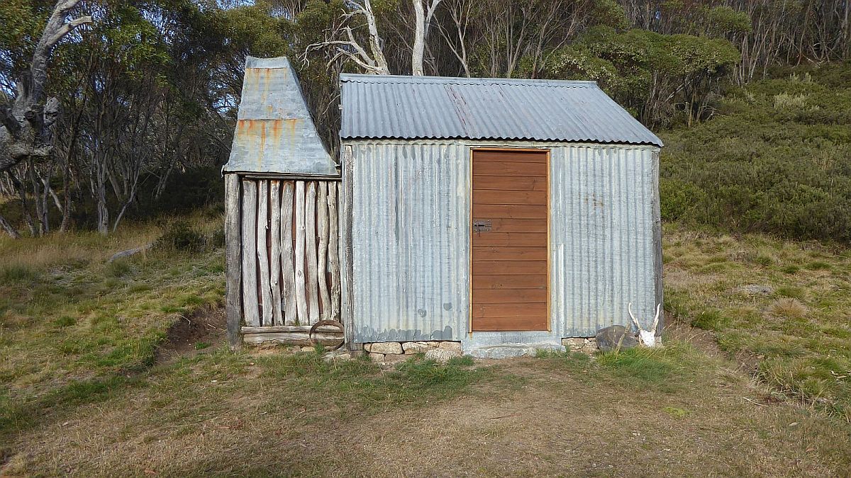
The hut had been rebuilt in the last year and looked clean and cosy. However, whilst it had a small table which enabled us to cook on there were no bunks to sleep on. There was a fire that worked well BUT the chimney didn’t seem to function properly with too much smoke accumulating inside the hut. I also feel that the pile of large stones in the entry was a risk, as it would be easy for tired walkers to slip whilst leaving the hut. However, the four of us negotiated the boulders without too much trouble.
The Well. This was something that Robert Green had raved about in the past. Too bad Robert, it’s now dry and someone has dug it up a bit trying to get it working again. It was completely dry for us. We did read an item in the log book where someone had written there was water in a creek 200m directly north. I also remember getting water from that source several years ago when I was returning from surveying the Bolton Hill diggings for David Scott. The latter are not well known but are certainly the most interesting diggings on the south side of Tabletop Mountain.
That afternoon we decided to start our survey by walking uphill from Brooks Hut but more on the north side of the hut and reached the top fairly quickly. We had made a decision to place pink tape on as many trees as we could and GPS those spots with Dirk and Stephen GP’sing the route. I decided to GPS the tapes with my new Garmin Etrex32x. We then headed on a north east direction across mostly open grassy fields until we could see a gap in the trees to the north which enabled us to walk easily and uphill on a defined ridgeline. We then had to wind ourselves through a short amount of timber until we exited the growth on the western side and then we were at a spot we well remembered from previous trips as a Rock Lookout. It still offered great views over Happy Jacks Plain as well as views to Far Bald Hill and even Mt Jagungal. We even could look down and see Brooks Hut below us.
We left this spot and continued out walk northward along a wide but distinct ridge with mostly open grassland with a few areas of rocks until we were just on the southern side of Mulligans Hill. This also had a trig point and marker in the ground on its top labelled Mulligans 2 Trig SMA 397. We knew it had a trig point on its top but the old route bypassed it on its east side which is where we went. It was awkward walking as we were essentially walking across a slope but it soon changed to grassland as we dropped down into a gap. We stopped and reviewed our position but we decided to continue further to see if we could find point Mulligans 1 Trig SMA 396 which was a small concrete plinth in the ground. I think Stephen who had previous data on his Garmin GPSMap66i found it. We had all spread out a bit as we went slowly uphill but reassembled at the right spot. It was getting late so after a short debate we decided to return the same way we had come and, on the way, re-verify the markers that we had laid. Sounds easy but replacing tapes and adding more was not easy to GPS.
We also had made a decision that we would use the PINK tape to label a normal point and PINK plus BLUE tape would signify what we thought might be an appropriate location for formal Track MARKER. On reflection I don’t think we actually recorded which spots would make a formal Track MARKER.
We made it back to the Hut with some daylight still available. We all cooked our own meals on a range of small stoves but we were all outdone by Kirk who brought a medium sized cooker plus enough food for an army. I even got to taste a Yumi’s Felafel ball that he raved about. You can do these sorts of things if you have a vehicle but backpackers mostly try to keep their weight down and exotic food is usually quite rare.
Day 2 Saturday 5th April
We all arose fairly early, breakfasted as you do, and got ready for what we expected would be a full day. We had to devise a plan as we had only checked and gps’d the southern part of the Arsenic Ridge trail and we now had to do the northern or top section.
I stuffed up a bit as I left my Garmin GPSMap66i next to my tent and my Garmin Etrex32x was placed on my shirt pocket and I forgot where I placed it.
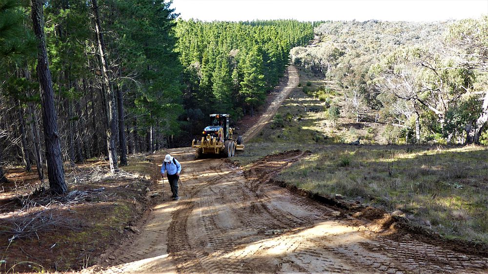
We headed out with four of us in one car Kirk’s 4 Wheel drive. We drove down the main trail and locked the gate after us with Mika keeping the key and drove east on Happy Jacks Road, then to the Tobar Rd then on a bit of the Tabletop Trail before detouring to Happys Hut just to check it out, as we hadn’t been to the newly rebuild version. We then doubled back and took the Tabletop Trail up to near Tabletop itself. It was a slow trip as the trail was OK but extremely bumpy due to clumps of grass on the trail. We parked the car near the start of the Arsenic Ridge trail.

Initially we all walked across to the site of the ruin of the Tabletop Hut site. According to an old Kosi map produced by NSW Lands Dept in 1934 the Arsenic Ridge Track went past this hut which was built in the 1900’s and destroyed in the 1960’s. According to Davis Scott’s data the GPS is 636415E 6017320N. Apparently it was built by a Mr Nixon of Wagga. There was also an Airstrip Hut built by SMA c1950‐70. Its exact location is unknown. DS had it at about 636485 6016880. Its exact location unclear (+/‐ >250 Site of former hut, possibly associated with the airstrip or a roadside shelter he states).
It looks like the Arsenic Ridge trail start point was moved several hundred metres along Tabletop trail until it reached a small rock on which a small cairn eventuated.
A document Named “The Wanderings of the Trevrylda Snowgums” gives an amazing picture of life and conditions in those days.
It was also labelled Daphne Ball’s Walk Journal, Kiandra to Kosciusko, 24.12.1936 – 10.1.1937
This old document was in Original typed journal scanned by Robin Mitchell with Text extracted and compiled by David Springthorpe in March 2012
It describes a visit they had to Tabletop Hut and later Boobee Hut, etc.
“We passed through some very interesting country after meeting Frank Yan and also saw a number of cattle that were very interested in us but did not prove troublesome in any way, the track leading through avenues of trees and then round the foot of Table Top Mountain to the hut where we were joyously welcomed by Mr. Nixon’s dogs and then Mr. Nixon himself who immediately put on the billy and invited us to HAVE A CUP OF TEA.”
Mr. Nixon very kindly invited us to cook in his hut, and as it only consisted of one room we put up “Old Faithful” in a protected corner of one of his corals where we spent a most comfortable night.
After our dinner to which Mr. Nixon donated milk and cream, we sat round the fire listening to Mr. Nixon discoursing on his droving life and answering our many questions. He told us he came from Wagga and only brought the sheep here each year for the summer season. He had a lad assisting him, who was at present home for Xmas, but other than this chap, saw very few people.
We said goodbye to Mr. Nixon shortly after ten and set off on the track in front of the hut, taking the left-hand track at the first junction.
Coming to a fairly large creek we were discussing a subject which was not wholly of a non-intoxicating nature and much to our horrification on looking up the map found it was called Temperance Creek.
We were very much surprised to see so much wood about for we had been told that we would be lucky to find enough to cook with, yet here was acre upon acre of lovely big logs that looked so inviting we felt like staying and having a huge camp fire.
We decided not to follow down Arsenic Ridge to the river as the track was shown in our map, but to go down the side and cross the Happy Jack Plains to the Happy Jack River as there was good fishing in the river and with our expert fisherman, we would have an abundant supply of fresh fish for tea.
Just as we were about to lunch the rain started and as one shower followed another, we very nobly decided to sacrifice our fish dinner and get to the Boobee Hut as soon as we could.
Later they got to Boobee Hut and recount a story of where it got its name as well as climbing Far Bald Hill behind the hut.
 Our journey continued:
We walked down the old route for Arsenic Ridge taping some trees as we went. We reached the race that we had crossed several years ago. It was now a little more overgrown plus a large tree branch had fallen across and into the race, however it was easily bypassed as we then continued up along a ridge before turning to the east and then walking into a small gap in the treeline which enabled us to walk in largely open country down and onto a small ridgeline that took us down to Temperance Ck. It had flowing water so I filled up my water bottle and then we climbed up along an old alignment or cutting before climbing up over grassland before it flattened out and we could walk south along the edge of a valley. We continued fairly easily until we could cross a small tributary of Temperance Ck, again with running water before continuing over open ground to reach Boltons Hill Firetrail. On reflection I think the walk along that valley was the most interesting and easiest part of the whole journey. The firetrail had been recently cut so it was easy to walk along.
We then had to decide our next move as someone or two had to go back to the car near Tabletop and some had to continue down to at least the Mulligans 1 Trig SMA 396 where we had finished the day before as well as make any adjustments in the markers from the previous day and also walk all the way back to Brooks Hut.
Kirk and I then had to return to his vehicle and drive along that bumpy dam firetrail

If we ever get the Arsenic Ridge Track built it might be a better route for AAWT walkers then that dastardly Table Top Trail.
Well, we did return OK and had a short break at Temperance Ck again before reaching his vehicle.
Strangely enough at the car a bicyclist has stopped and needed to fix some issue with his pushbike. We didn’t have any of the right tools or equipment so couldn’t help him. As we drove back, we passed more cyclists who were all part of the same team of around 10-12 cyclists. I saw a note in Facebook later that a KHA member had organised a group of cyclists to park at Mt Selwyn and then they were cycling out to Mackays Hut. Stranger was we had met two older walkers along the Tolbar Road section who were walking from Happys to Mackays that same day. These to were walking on very hard surface on the Tolbar Rd whereas they could have used a softer dirt on the Tabletop Trail section. Apparently, they had other friends walking across country from Happys to Mackays. Sounded like there might be a lot of people hoping to camp at Mackays that night.
We continued driving down the trail and then we realised that when we got to the Happys Jacks Bridge we didn’t have a key. Luckily Kirk still had a NPWS Walkie Talkie device and was able to talk to Mika who had reached Brooks hut and asked him to get the key to the bridge for us.
We got to the bridge OK and had to wait only 5mins or so before the other two turned up with the key.
It was a cold night at Brooks Hut but we assembled in the hut for dinner. Stephen cracked a bottle of wine and we all ate well as far as I can determine.
I was able to find my Garmin GPS’s Ok but disappointed that I hadn’t been able to use them effectively.
Day 3. Sunday 6th April
We arose probably a bit late as I guess we were all tired after a strange day previously although we had achieved our goals. All we had to do was to get home safely and send our finding to the NPWS.
We packed up ok and filled up the two cars with all our stuff. I returned to Kirk two tent pegs that I had borrowed on the first night. I looked around my tent but could not find any trace of the two MSR pegs that I had lost on the first day. It was quite windy setting up my tent on the first day and I had to move it a little as the ground was not exactly flat. I think a gust of wind had blown part of my tent into the air with pegs attached which may have flown off into the bush before I could peg then down properly. There wasn’t much bush around but just enough for the pegs to disappear. I had one spare but had to borrow two pegs. I never found the pegs when we packed up on the Sunday. Really quite strange as I have had those pegs for more than 10 years.
For some reason that I can’t for the life of me remember we decided that we would drive down Happy Jacks Rd to the Boobee Hut turnoff and either walk or drive to simply check out Boobee Hut. I think the others had never been there. I had, so its wasn’t something I agreed with.
At least we were smart and all piled into the one 4WD and left the other car just off Happy Jacks Road. The vehicle made it to Boobee Hut OK but I must admit I would never agree to drive there again. The trail is heavily provided with those metal tank tread sections although most are rusty and severely damaged over the years by hut maintainers or service vehicles. The hut is in great condition and seems to have been upgraded with bunks and maybe a new fireplace. An old metal fireplace outside seems to have been removed.
On the way back on Happy Jacks Road Kirks vehicle got a flat tyre probably due to the condition of the tank tracks which puncture his left rear tyre. He had tough job getting his spare tyre to wind down under his chassis as well as getting the jack to lift the rear part of the vehicle. Eventually it worked and we could get on our way. The other vehicle went out via Tumut Ponds Road whereas Kirks car went out via Eucumbene Dam.
Amazingly both cars stopped at the Lott Café in Cooma at nearly the same time.
Some photos are in this post, whilst all I could assemble are in an album in Google photos entitled “Kosciuszko National Park 4-6 April 2025 – 3rd Survey of Arsenic Ridge Track” accessed through this link
Files for Trip GPS data accessed through this link
Members of the Team: Leader Mika Kontenien (ANUMC), Stephen Joske (CBC), Kirk Honan (CBC, Lifeline), Greg Hutchison (Lifeline, Vinnies, KHA)