2021 03 11 Kama & Molonglo River Reserves with MelbaShed
This was an 9.3Km Medium walk from a parking spot along William Hovell Drive, just outside Belconnen, Canberra down along several tracks through Kama Nature Reserve to a dirt management road along the north bank of the Molonglo River which is now part of the Molonglo River Reserves. This was Melba Shed walk No 251 of 11th Mar 2021.
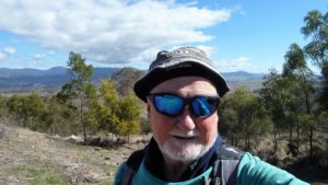
Featured image – Melba Shed guys overlooking the Molonglo River Valley
I led this walk with 6 walking. 5 met at Melba Shed and drove to a parking spot along William Hovell Drive around 2.1Km along it from the Drake Brockman roundabout in Belconnen. Here we met one more.
From 8.21am we headed out through an underpass & then through one of numerous gates which were all unlocked or with walk throughs in them. We headed down the eastern side of the River walk passing some interesting trees & a large amount of overgrown but dying thistles.
Reaching the Molonglo River Reserve which has a nice dirt road running east west along the north side of the Molonglo we decided to climb a hill on the south side which has Stromlo ST10 Trig on its top & also afforded great views over the Molonglo.

Some went back down to the road whilst some of us dropped down & sidled around the lower edge of the hill all meeting shortly back on the road. We then went west for around 1.5Km passing some sewer vents & pipelines that seem to cross side valleys hoping then to get a view of the Molonglo Gorge.
However this we failed at & only saw two small rocky gorge sections. So we turned around & went back & down to be close to the Molonglo for a break & then returned back up the River Walk on the west side to the cars around 11.44AM.
3 of us had coffee and shakes at the Mame Cafe in Melba. Its a nice little cafe with good service in the Melba Shops.
It was an Medium walk of 9.3Km, taking 3hrs 23m incl breaks.
Walkers: Bob Salmond, Drew McDonald, Harry Angel, John Edge, Neville Viney, Greg Hutchison
Drivers: Neville, Drew, Harry, John
Map of walk | Pictures in Google Photos | files including gps located in Google Drive
Notes re Map: GPS Map View provided using Garmin Basecamp on an Open Streets Map (OSM) NSW base | The area of the walk is covered by the NSW 1:25,000 topo map CANBERRA