Kosciuszko National Park – 12-15 Apr 2021 Gungarlin Kidmans Cesjacks – Jagungal Area
This was a 4 days and 38.1Km medium-hard walk from the Snowy Plains near the Travelling Stock Reserve (TSR) to Kidmans Hut, then up through the Burrungubugge Ck gorge to the main Range near Mailbox and across along the Bulls Peak Range to Cesjacks then back down on the Snowy Plains Fire Trail with a detour through Snowy Vale.
The featured image is a view of Mt Jagungal from near Nimmo Hill 12 Apr 2021 after heavy snow falls on 11th Apr
Kosciuszko National Park – 12-16 Apr 2021 Gungarlin Kidmans Cesjacks – Jagungal Area
Introduction
This was a 4 days, and 38.1Km medium-hard walk from the Snowy Plains near the Travelling Stock Reserve (TSR) to Kidmans Hut, then up through the Burrungubugge Ck gorge to the main Range near Mailbox and across along the Bulls Peak Range to Cesjacks then back down on the Snowy Plains Fire Trail with a detour through Snowy Vale.
On the morning of the 12th Apr 2021 I set off from Canberra and headed to the Gungarlin River Camp Site to walk across the Southern Gungarlin valley, called the Snowy Plains to Kidman’s Hut, thence up an old bridle trail route to the Great Divide just north of Big Brassy, then across to the Mailbox, along the Bulls Peak old trail to Cesjacks and then down and across the Snowy Plains to my car. Originally this was planned as a 5 days trip with at least a day checking out the old trail across the Strumbo Range to the GreyMare Trail.
This was a shared trip with Robert Green trip with all proper precautions taken and following the planned route mostly. My pictures of this trip are available on Google Photos.
Warning & Dangers
The area mentioned in this writeup is largely rugged and untamed. Yes it was grazed in the Stockmen’s Days and many walkers have negotiated the area since. There is substantial bush to be negotiated and some large trees to be wary off. The area was heavily burnt in the 2003 fires and has recovered with a vengeance i.e. the scrub in 2021 is sometimes more dense than what was there in 2002. The climb from the Gungahlin Valley at the junction of Teddy’s Ck and Collins Ck is not difficult but the track negotiates an area bordered with extremely large and tall gum trees, probably alpine ash, all of which were heavily burnt in 2003 and many large trees have fallen, some across the track, although now mostly cleared. There is no formal track past the Little Brassy Gap (also shown as Brassy gap on maps) which is the location where you would pass through the Little Brassy Range and then head down to Kidmans Hut. This gap is often covered in snow in winter up to October. Mobile phone coverage is limited with Little Brassy Gap and parts of the Great Divide (Including up behind Tin hut & maybe the Mailbox) being the only spots where coverage is guaranteed. The altitudes are also high for Australian walks with the Gungarlin Valley, that one walks through, around 1,300-1,400m (and can be snow covered in winter), 1,620m at Little Brassy Gap, 1,515m Kidmans Hut, 1,855m crossing through the gap north of the Brassy Mountains, 1,810m at Mawson’s Hut, 1,860m at Tin Hut, Gungartan Pass 2,000m, Mt Jagungal 2061m.
Note: Waypoint/Points mentioned in this post refer to waypoints in the GPX file as well as shown on the trip maps.
Day 1 – Mon 12th Apr
I left Canberra around 6.00AM and after getting a newspaper I drove to Cooma where I refuelled at the Woolworths petrol station and had coffee and some breakfast at Maccas where Robert Green joined me. We then drove via Rocky Plains down to the Nimmo Bridge crossing of the Eucumbene River, then up to Nimmo Hill and then down to the crossing of Gungarlin River. I took the small bridge and Robert crossed through the river ford. The section from Eucumbene Road to Nimmo Hill was still quite rough in places. Lucky I had a Forester as I would have struggled in a conventional vehicle and Robert had a Range Rover. However it was still slow going through multiple gates and we reached the location where we parked Robert’s car, at the gate to Snowy Vale at around 11.15AM. Parked Roberts car near GPS 55 H 634140 5998666.
On the Snowy Plains FT we came across some locals one being the son of Harley Hedger and who was carrying on the trade of shooting feral animals including wild dog. We also met Mr Vanzella of Pambula who was going to his hut hidden south of the Bulls Peak Ck area. It’s the hut I knew as Tin Hut. Apparently they have about 12 members and whilst a couple are Cooma Ski Club members the ski club has no association with the hut. He also advised us that Mick Klema of Cooma had bought the Bulls Peak Lodge from the Gillespies and that the new Clancy Hut was owned by a Chris Smith.
We then drove back in my car to near the gate to the Travelling Stock Reserve just west of the Gungarlin River but along the edge of the Snowy Plains Fire Trail. Parked my car at GPS 55 H 639526 5993653.
We then started the walk around 12PM ie noon walking across Jardine’s property for a short distance, past a weather station and up a hill and into the KNP having to pass a barbed wire fence near a treeline and behind a big rock.
We then followed a recut fire trail across to pick up another firetrail that comes down from the Barley Fields. We then followed the very walkable trail down to the trail along Teddys Creek and had to walk back north west around 60m to cross Teddys Ck at the junction with Collins Ck. Here we stopped for lunch and to take on some water.
We then headed up towards Mill Flat and then continued on and up through the nice forest track. Most fallen trees had been cut or cleared enough for walkers. We also continued on to my first top or gap known by me as Little Brassy Gap at 3.20PM.
Most of the way up from Teddys Ck had been cleared by NPWS early this year although a couple of small trees had fallen across the trail just below the top of the gap. However in several areas small amounts of bush had to be brushed past. It’s not by any means a well maintained track, but it’s quite easily walked.
This was the highest point on Day 1 being around 1,635m. Mobile Phone calls (Telstra at least) can be made from here. From this spot one usually gets a splendid view of the Brassy Mountains to the south-west as well as the ridge to its north to The Mailbox. The whole upper Burrungubugge River valley was also in view, although I could not see Kidman’s hut from this spot.
The name of this gap derives from the sketch map “Mt Jagungal and the Brassy Mountains” produced by Tim Lamble of Sydney in the late 1970’s. I have the 1st edition which I have heavily updated. There were three more editions and I also have pristine 4th Edition. In this map Tim called the gap Brassy Gap, as does an old historical article about someone’s journey to Alpine Hut. In this article they also defined the mountain range in which the gap sits as the Little Brassy Mountains. Hence my term Little Brassy Gap. There is also a further gap right on the Great Divide, actually more of a low point through which the bridle trail went as its route to the upper Valentine Valley, Mawson’s Hut as well as linking up with the old connection along a plateau south of the Mailbox and to Bulls Peak Trail. This later gap is logically the Brassy Gap, although in effect it represents the transition from the Brassy Range to the lower plateau just mentioned.
We then continued down the large open area below the gap. The actual old vehicle ruts do disappear part way down. Walkers would then need to walk across vague foot pads to reach an area left of a large stone down on the south side to then enable picking up an obvious small cutting which then takes the walker down to a creek that has to be crossed; which we did easily. Then we continued down across a couple of minor creeks on the north side, over more fields, across another side creek and then to Kidmans Hut. The route was slightly overgrown in a couple of spots, although a couple of spots has been well cleared.
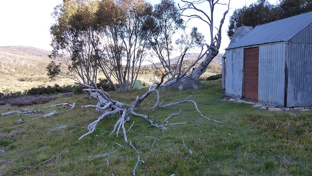
We reached Kidmans Hut at 4.08PM which was good as it gave us time to put up our tents, collect water and also some firewood. Water is available around 30-40 metres down in the nearby side creek. The water point is steep and it’s always tricky to get water without slipping into the small creek. Actually one foot of mine did end up in the water but my boot only got slightly wet.
On Day 1 we did about 10.2Km to Kidmans & of course we had driven around 200Km as well.
The wood was damp. But I managed to have a small fire outside which I had to prime by blowing concentrated air in a “slurp tube” to keep it alight. I used bits and pieces for dinner cooked on my stove, ie a soup packet, some potato powder, some of my freeze dried seaweed, some cous cous and some TVP. It was fairly light, easy cooking and easy cleaning. Overall it worked OK for a main dinner. The weather was fine. Robert cooked on his stove inside the hut but also boiled water on the inside fireplace. It was our best night with a crystal clear night sky. However it was a freezing night. I had to migrate inside the hut to read my kindle it was so cold. Robert also read his kindle.
The one thing that I found annoying was that I had left my normal cup at home so had to borrow Roberts or drink out of a medium sized plastic plate. You try enjoying coffee from a plate! Yes! I was a dingbat to leave it behind! This was another outcome of getting a new pack.
Kidman’s Hut GPS 631845 5991223, altitude 1515m. It’s a corrugated iron original stockmen’s hut built about 1932 by Ken and Alec Kidman, Bill Napthali. It’s a single room, 3.6 x 3m unlined, fireplace, with a stone floor. The corrugated galvanised iron was fixed to nogged timber frame. It has a wooden board door, with no window. The fireplace with timber frame, galvanised iron cladding and rock lining. The fireplace was rebuilt by NPWS tradesmen in 2007. According to Robert the floor was covered in stones after the fireplace was rebuilt by Ian Frakes and hut maintainer Ian Macaulay around 2008. (Data mostly from David Scott)
Day 2 – Tue 13th Apr
We arose early around 6.30AM to a freezing morning with my tent covered with a thick layer of that snow like frost.
We had decided to have an easy day with Robert contemplating some fishing over on the main Burrungubugge River. We then decided to walk up the route to the top of the range and suss out the current status of the route. So we left at 9AM. I carried a small fold up day pack. David carried minimum equipment although he carried his stove and some food.
We followed the old historic bridle trail route up from Kidmans, although the first section is a steep climb up small recut section until we reached the small plain above. Then we passed a large cairn on a rock WP 111, crossed a small low scrubby section before we could see another small cut section from WP 112 (Rte up). This spot marked where we could follow a footpad up to a higher open area next to a Cairn WP115. From there we went south west down to a new marker WP M01 which then allowed us to get easily to another Cairn WP 117. We then headed across the valley with a creek WP 118 Ck before heading slightly uphill past point WP 119 then point WP120. Along this last section there was a lot of thick woody low level scrub which had to be walked around before we reached the point WP 121 Bottom Burrung Gorge. We were now in the real Burrungubugge Gorge which we knew fairly well and would take up to the McDonald diggings and a large open plain above its top.
We initially went to point WP 122 but had some issues finding the right path after this. After a couple of tests we could ascertain a route close to the original route and thus we ended up with several new WPs to get the route in walking order. These were WPs 002, 003, 004. From here we were able to follow all the points up to the top of the gorge and was then able to travel up the Burrungubugge Gorge to point (WP 130 Top). We then traversed across the top and to the north-west side of the River before we could easily cross the Burrungubugge around 200m from the top point. The stones are on the south side are; ie McDonald Diggings GPS 630416 5991396.
We then went up across a large open field using a thin footpad towards the next ridgeline that had to be climbed. We reached point WP 133 (Jn for Alpine) where in the past I had turned to traverse the small valley in that direction before it goes over a crest and heads towards the old lost Alpine Hut site.
On this day we headed up a lightly scrub covered ridge to reach an area that stockmen used to camp and rest their stock before taking the final climb up to the Great Dividing Range. Here we stopped for a 45min break with Robert boiling the billy on his stove.
We then headed south to pick up point WP 136 Cairn Tk Bottom on a rock that represents the spot where the old Bridle Trail turned slightly south to then go up a ridge to the next level of the river, a large open bowl below the Mailbox and its southern ridge that is the start of the Burrungubugge River.
Near the WP136 Cairn there is an old historic Cattleman’s fireplace GPS 629902 5991094.
We headed up with the first section proving easy up to a small open spot WP 144. The section up to this spot is probably the steepest on this route.
We then headed up slightly to the left or south of the original old trail. However we managed to follow some old orange/yellow tape markers up and we took a range of new WPs to try and lock in a walkable route. These WPs are shown in the data as points 005 through to 026. Many of these are close to old points and I will rationalise these in due course. The top section is covered with some small yellow tags which guided us correctly up to WP150 which is where we broke out of the treeline and could see all over the area to the east and out to the Monaro Plains. It was then a short trudge over some low level scrub and grass to a large rock, point WP151 Tk Top.
We then went north across to point WP 152 Burrung R Water which is where one top branch of Burrungubugge provides easy access to clean water. GPS 629470 5990744.
The Burrungubugge rises in a large partly swampy valley which lies just east and below the Main Range ridgeline as well as peaks such as the Mailbox which meld with the range to feed water down into it. This is where we now were.
From here we headed back down to Kidmans and on the way we made some mistakes but then refined a little what we thought was the best route up from Kidmans. We reached Kidmans around 2PM and had an easy afternoon.
Today we did 7.0km.
Around 4PM a group of 8 hikers from the Newcastle Ramblers Bushwalking Club arrived at Kidmans. They were all oldies like us and varied in age from 58-76. They had spent the previous night at Daveys Hut and were planning to use Kidmans as base camp and do a couple of days walking up to maybe the Mailbox and maybe Alpine Hut location.
That night was very windy and although they enjoyed themselves around the outside fire and inside one as well some of them suffered a little with one of their older tents nearly having the fly take off in the wind. It was a howling noisy night.
Day 3 – Wed 14th Apr
I arose quite early around 6AM but we still didn’t get away until around 8.35AM after a cold windy night.
We made good progress up the same route as yesterday but I found the steep section above the Stockmans Camp area quite tiring and rested on the rock in the small open area just at its top.
We reached the top of the climb to the open area above around 10.52AM for a short rest and then headed off around 11AM up to the north-west initially across some rocky ground and a grassy ridge for around 500-750m before we had to slog across swampy areas before climbing up and over a rise to again have to cross another swampy section. We finally had to cross some open ground for the last slog across to an area south-east of The Mailbox which gave us some shelter from a roaring wind. This spot was right on the old trail along the plateau east of Mawsons, past the mailbox and along the Bull Peak Ridge to Cesjacks. It was just after 12noon so we stopped for lunch. I had to go 200m west to find a small creek coming down from the Mailbox to get some water as I knew there was none along the Bulls Peak Ridge.
We headed off about 1.04PM and initially followed a rut from the old trail up and over a crest and then down to meet the main old route of the Bulls Peak trail around point WP 507. It was hard to follow the old route and without several old versions on my GPS we would have made more mistakes. All in all we did quite well and were mostly close to the route. Near point WP Pt40 we could see a short section of dirt and rock of the trail whereas most of it was grassed or covered with scrub. Just past this point we were able to go to the east side and pick up a cut out section that takes the trail east of a peak and then north to pass west of the North Bulls Peak. It’s easy going along here. However near point WP 483 NthPk it became a mixture of grass and large patches of scrub so I headed down hill and eventually picked up the old route right near a starpicket (WP BS605 Post). This was a NPWS marker for something they needed to spray years ago. Robert had gone straight ahead and was 100m or more higher up the slope. I finally got his attention and he joined me and we headed north and across a saddle which represents the start of the Upper Geehi Valley, and then climbed back up to reach Smiths Perisher. We went slightly off track here but recovered to follow the old trail around to the north side of Smiths Perisher where we went a little wrong again.
It appears that many have been taking a route down/up Smiths Perisher from the north side on an alignment towards the east. From the bottom of the descent from the hill we picked up the old trail again and then followed it around to the north. However we seemed to be too far to the east along a short stretch. Going slightly downhill to the west at point WP058 we picked up the old trail again at point WP059 and then followed it all the way to Cesjacks. However we noted a new bulldozed fire track leaving the Bulls Peak Trail to the south west around 150m from the turnoff to Cesjacks itself.
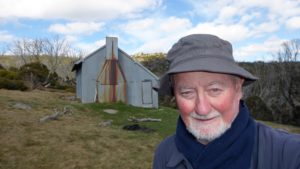
We reached the hut at 4.54PM just in time to set up my tent and collect some water. We both cooked on our stoves inside as well as had an internal fire to keep us warm. Robert slept inside on the sleeping platform, whilst I slept outside in my wind-blown tent. It was another high wind night although all the clouds had disappeared.
We debated whether to stay another day and look around the route to Strumbo Hill and the Greymare Track. I thought Robert was all keen to do this but he rationalised this now, not wanting to spend another day facing the winds that we had experienced I believe. And what we saw in the morning seemed to bear this out as a good decision.
Today we did 14.9km. It felt like a long day.
Day 4 – Thu 15th Apr
The wind was still very strong in the morning making it hard to take my tent down and fold it up properly.
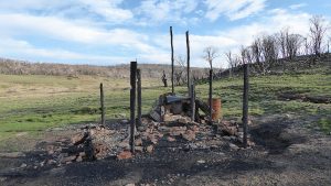
After breakfast and packing up we didn’t leave until around 9AM and headed straight out and down the trail towards the border gate. We did note that the main trail we were on had been bulldozed probably for the 2020 fires and we could see some scrub to the north side of the track having been burnt out. The south side of the track seemed untouched.
We left the park and in 150m we took a right turn and climbed over the gate to enter the SnowyVale property which is registered community incorporated body in which the owners join by paying a substantial joining fee. It’s essentially a private ski lodge with a lot of area and several buildings. Robert was keen to go there and see if it offered any advantages to walking down the main trail. We think it did. Initially we came to their Top Hut which is only some 150m down from the main Cesjacks Track and 40m down from the park boundary. We then took a trail down 1.6km to find the main SnowyVale Lodge building which is itself surrounded by a wood stack building, a machinery & ski equipment shed and a shelter for gas cylinders. Instead of walking down the main road, we took another footpad/ski trail down another route 600m to their lower hut Wallaces. This was the site of an original hut, which was rebuilt and then SnowyVale renovated the hut to its current standard. Non-members can stay in the hut if it’s an emergency but staying there is not encouraged. From Wallaces Hut its 300m metres down to the gate with an adjacent stile over the fence.
We reached Roberts car at 10.50AM and then spent 15min as Robert changed clothes.
We then drove down to my car along the Snowy Plains Fire Trail reaching there around 11.30AM and by the time I changed and we left it was close to 12 Noon.
Today we did 6.0Km, not a massive distance but a lot of nice trails and grassy footpads and minimal navigating.
On the way out we bumped into James MacCormack, the editor of Wild Magazine on his mountain bike, at the corner of the Nimmo Rd and the Eucumbene Rd. As he said one or two minutes either way and we would have missed each other. Robert knew that he was visiting the area but was expecting that we might see him on Monday when he planned to do a trip along the Snowy Plains Fire Trail and across to Crooks Racecourse.
Instead he delayed it until today because of the strong to gale force winds which have persisted all week, and had changed the route to use the Happy Jacks Rd and the Grey Mare FT to reach Mackays tonight.
We both got to Cooma OK and had lunch at The Lott café along Sharp St on the west side. It seems like a nice and well liked location.
I got home fairly early around 5.00PM which was Ok.
Some Thoughts on Old Tracks and Bridle Trails and Their Usefulness to Walkers and Management
Email extracts with some thoughts from Robert about the status of the route from Kidmans to the Great Divide and lamenting the lack of maintaining such tracks and routes
The route up the next ridge (ed. referring to just above Kidmans) is now very much overgrown compared with what it was 15 years ago, all of which is confusing to old souls like me who don’t see what they expect to see. For instance, at the top it used to be quite open once one climbed the steep section at the bottom; an area where there is…… an excellent track. But now, it is no longer open from that point at all.
On Wednesday, we went up the same way again. From the top we cut across directly for Mailbox and then on to Cesjacks. I expected to see remnants of the Bulls Peaks Fire Trail from about South Bulls Peaks north, but it was not until a little north of North Bulls Peaks that it was reliably visible and down Smiths Perisher it has disappeared again, with the result that people are bashing down that hill rather than following the old track and its, better, alignment.
It would be a simple job to keep the Bulls Peaks Fire Trail open, simply by pushing aside a very few fallen trees and running a small tractor and slasher along the old track, with someone going ahead to keep the driver on the old route. It would only take two days and thereafter one slash every year or so would be plenty. Such a route might also be useful for fire, weed and pest management, because the area is now inaccessible by vehicle and must rarely be visited by Park Management. For instance, hawkweed, which now appears to be on Snowy Plains, is inevitably in the Bulls Peaks area, festering quietly and unseen. Fire management would also benefit from an improved access.
Such work, in a Wilderness area, is consistent with the Burra Charter which says that:
“The management of cultural resources on reserved land is an important aspect of the management of parks and protected areas. In most states and territories it is a statutory requirement that government agencies responsibly manage cultural heritage assets.
“Conservation is the safeguarding of a cultural resource, retaining its heritage values and extending its physical life. In this context conservation includes not only preservation but more interventionist work, such as restoration or adaptation as reflected in the Australia ICOMOS Burra Charter definitions.”
Incidentally, Greg and I had the impression that the route into Kidmans as far as Little Brassy Gap had been cleared, but that was not the case so we must have misunderstood the story.
I was surprised to see the amount of regrowth in all areas and it no doubt impacts on the viability of some of the suggested walks. It astonished me that virtually all of the Bulls Peaks FT has gone, though all of that route is still relatively easy walking.
My (Greg’s) Comment
Whilst some of the trail up to Lt Brassy Gap has been cleared, there is still substantial scrub to get through albeit the route is quite walkable. The route and old bridle trails are overall quite heavily overgrown but that is similar all over Kosi NP and has been exacerbated by the large amounts of rain over the last year or so. For instance the area around the burnt 4Mile Hut has the highest grass covering including height I have ever seen. The nearby creek is covered with mint which I can’t remember seeing before. Thistles are everywhere in northern Kosi. Whilst Robert can refer to the Burra Charter, NSW NPWS seems to take more notice of the very constraining NSW wilderness act that holds sway over most of the walk area we did. However one thing is a clear, as night follows day, KNP will burn severely again in the years ahead unless the authorities undertake more stringent and widespread fuel reductions burns, including wilderness areas. Some of that will inevitably require more and better maintained fire trails.
Distances
Distances per day, Km.
| Distances per Day | Distances (km) |
| 1. Snowy Plains FT to Kidmans Hut | 10.2 |
| 2. Kidmans Hut to Main Range return | 7.0 |
| 3. Kidmans Hut to Main Range to Bulls Peaks to Cesjacks Hut | 14.9 |
| 4. Cesjacks Hut, to Snowy Vale Gate | 6.0 |
| Total | 38.1 |
Car Distances
The distance was around 200Km one way from Belconnen, Canberra via the Monaro Highway, Cooma to Rocky Plains, then Nimmo Rd and Snowy Plains FT.
GPX Files
I have from my GPS, created a single GPS file that shows 6 tracks, one per day of walking, plus some auxiliary tracks for trails along Snowy Plains, plus lots of waypoints.
I intend to edit the tracks and waypoints to make them consistent with previous tracks and waypoint numbering
GPS Files are:
- KNP Apr 2021 Final.gpx The main format for GPS now
- KNP Apr 2021 Final.gdb The old garmin format
- KNP Apr 2021 Final.kml..Google Earth format
Relevant Topographic Maps
The topographic maps covering the area of this trip are:
1:50,000 older maps: Khancoban & Eucumbene, if you can get them.
1:25,000 newer maps:-
- Nimmo Plain for Teddy’s Ck and trail, Davey’s Hut, Snowy Plains, Gungarlin River
- Jagungal for part of the Brassy Peaks & Mountains, Mailbox, Mawsons, Kidmans, Burrungubuggee River, Cesjacks Hut
I recommend that keen walkers check out the use of Oziexplorer from Des Newman’s OziExplorer plus OzRaster from GPSOz
Use of Oziexplorer with OzRaster maps for NSW enables you to load up a gpx file and see your route (and one’s available off this trip) on a modern topo map base
Diagrams, Pictures and Docs Available
One Google earth kml file, one gpx file and one Garmin gdb file covering the trip with waypoints and daily tracks are in a Google Drive folder.
On the screen captured Oziexplorer maps:
Overview Map-
- Overall Trip “1. Overview of Walk 1.5km view Oziexplorer.jpg” is an overview Map of the 4 Days Trip using Oziexplorer and Topoview 2006 NSW topo details
Day and Detailed Maps-
Oziexplorer Maps using NSW Topoview Maps:-
- Day 1 – “2. Car to Kidmans Hut.jpg”
- Days 2&3 – “3. Day2-3 Kidmans to Main Range.jpg”
- Day 3 – “4. Day 3 Bulls Peak Range.jpg”
- Day 3 – “5. Day 3 Bulls Peak Range”.jpg
- Day 3&4 – “6. Day 3-4 Bulls Peak to Cesjacks to Snowy Vale.jpg”
- Days 2&3 – “7. Close Up Kidmans to Top Burrungubugge jpg”
- Days 2&3 – “8. Close Up Top Burrungubugge Gorge to Top of Track.jpg”. Note this one uses Oziexplorer with Ozraster NSW topo map.
Mapsource Maps using Oztopo Maps:-
- Overview of Walk 1.5km view.jpg
- Day1 Car to Brassy Gap.jpg
- Day1-3 Brassy Gap to Main Range.jpg
- Day 3 Bulls Peak Range.jpg
- Day 3-4 Bulls Peak to Cesjacks to Snowy Vale.jpg
- Close up KNP Bdy SnowyVale.jpg
- Close Up Kidmans to Bottom Burrungubugge Gorge.jpg
- Close Up Bottom Burrungubugge Gorge to Climb up last Section to the top.jpg
- Close Up Bottom of Climb up last Section to route across swamp to Mailbox.jpg
Notes: Map view extracts came from Oziexplorer using NSW DFSI Spatial Services approval for display of their base map from Topoview 2006. GPS files available on Google Drive. One map view comes using Oziexplorer with Ozraster NSW topo map provided by BKK Enterprises Pty Ltd, http://www.gpsoz.com.au.
Map view extracts also came from using Garmin Mapsource using Oztopo base maps with permission of © BKK Enterprises Pty Ltd, http://www.gpsoz.com.au
The trip maps and sketches showing the trip tracks and various waypoints of important locations are available on a folder in Google Drive and the Trip Maps are also in the Google Photos album. The Oztopo Trip Maps produced using Mapsource are in a sub folder
My pictures of this trip are available on Google Photos. The original pictures are all ~4000 x 2248, 16:9, 9.0 Megapixels, ~ 4Mbytes. The GPS map extracts are variable but around 800-1200 wide to 660-740 pixels high.
“Mt Jagungal and the Brassy Mountains” is an excellent old sketch map produced by Tim Lamble of Sydney in the late 1970’s. I have the 1st edition which I have heavily updated. There were three more editions and I also have pristine 4th Edition. I understand that Lamble will no longer produce any updates of this map so what you see is all that’s available. Some digitised versions have been made by myself and also by people with better facilities. If you need a copy contact me.
Categories: Kosciuszko NP, Mountains, Huts, NSW
Tags: Kidmans Hut, Cesjacks Hut, Bulls Peak Ridge, Brassy Gap, Little Brassy Gap, Snowy Plains, Gungarlin River, Gungarlin Valley, Daveys Hut, Burrungubugge River, Burrungubugge Gorge, Mailbox, Mt Jagungal, Snowy Vale, Wallaces Hut, Collins Ck, Teddys Ck, Bulls Peak Ck, Nimmo Hill, Robert Green, Newcastle Ramblers, Mill Flat,
Greg Hutchison, 21 Apr 2021