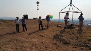
Kosciuszko National Park 24-28 Mar 2020 Gungarlin Kidmans Mawsons Jagungal Area
This was a 4 day and 45.5Km medium-hard walk from the Gungarlin River camp ground to Kidmans Hut, then up to Mawson Hut through the Snowy Plains in the Gungarlin valley, and through the Burrungubugge Ck gorge and to Mawsons hut, the Valentine Ck valley, Bluff Tarn and back.
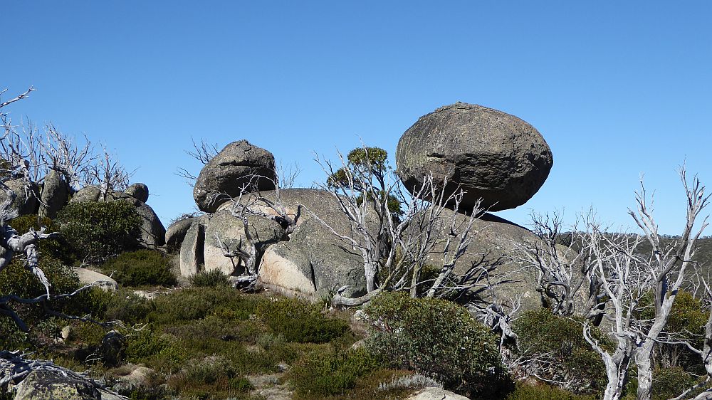
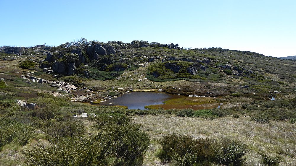
The featured image is a view of The Football
Kosciuszko National Park – Gungarlin River to Kidmans & Mawson Hut in the Jagungal Area with visits to Cup & Saucer, Bluff Tarn & the Football
Introduction
This was an effective 4 days spread over a 5 day period, and 45.5Km medium-hard walk from the Gungarlin River camp ground to Kidmans Hut, then up to Mawson Hut through the Snowy Plains in the Gungarlin valley, and through the Burrungubugge Ck gorge and to the Valentine Ck valley and back. I also climbed one spot on the Cup & Saucer, visited The Football and Bluff Tarn.
On the morning of the 24th Mar 2020 I set off from Canberra and headed to the Gungarlin River Camp Site to walk across the Southern Gungarlin valley, called the Snowy Plains, to Kidman’s Hut, thence up an old bridle trail route to the Great Divide just north of Big Brassy, then down to Mawsons Hut, then back to Kidmans and across the Snowy Plains to my car. I originally planned a 5 days trip with a day trip visiting the Cup & Saucer, Bluff Tarn & Mailbox from Mawsons.
This was a solo trip with all proper precautions taken and following the planned route mostly. My pictures of this trip are available on Google Photos
Warning & Dangers
The area mentioned in this post is largely rugged and untamed. Yes it was grazed in the Stockmen’s Days and many walkers have negotiated the area since. There is substantial bush to be negotiated and some large trees to be wary off. The area was heavily burnt in the 2003 fires and has recovered with a vengeance i.e. the scrub in 2020 is sometimes more dense than what was there in 2002. The climb from the Gungarlin Valley at the junction of Teddy’s Ck and Collins Ck is not difficult but the track negotiates an area bordered with extremely tall and large gum trees, probably alpine ash, all of which were heavily burnt in 2003 and many large trees have fallen, some across the track. There is no formal track past the Little Brassy Gap which is the location where you would pass through the Little Brassy Range and then drop down to Kidmans Hut. This gap is often covered in snow in winter up to October. Mobile phone coverage is limited with Little Brassy Gap and parts of the Great Divide (Including up behind Tin hut) being the only spots where coverage is guaranteed. The altitudes are also high for Australian walks. In the Gungarlin Valley, one walks through, an altitude of 1,300-1,400m which can have snow around in winter, 1,620m at Little Brassy Gap, 1,515m Kidmans Hut, 1,855m crossing through the gap north of the Brassy Mountains, 1,810m at Mawson’s Hut, 1,860m at Tin Hut, Gungartan Pass 2,000m, and Mt Jagungal 2061m.
Day 1 – Tue 24th Mar
I left Canberra around 7.16AM and after a nature stop at Bredbo I drove to Cooma where I refuelled at the BP Petrol Station had coffee and some food at Maccas. Note that I used plastic gloves or equivalent on the petrol bowser, paid with tap & go card and at Maccas drove through also paying with pay wave card and not touching any fixture. I also avoided being close to any persons. I then drove via Rocky Plains down to Eucumbene River crossing, then up to Nimmo Hill and then along the Powerline or Island Bend Fire Trail (FT) to the Gungarlin River Camp site. It was just under 200Km from my place in Canberra to where I parked the car. The last 17.2Km or so are on a dirt road, with the section past Nimmo Hill in a poor heavily rutted condition. The section from Eucumbene Road to Nimmo Hill had been graded last Oct, but is still rough in places. Lucky I had a Forester as I would have struggled in a conventional vehicle. However it was still slow going and I reached the location where I parked my car around 10.50AM. There were three vehicles parked near the bridge and I joined them by parking there. Parked car near GPS 638931 5987834.
I also noted that the NPWS were building a structure further east near the main camping area. I assume it was some form of shelter for visitors.
Gungarlin River Camp Ground GPS reading 638877 5987737, altitude 1300m approx.
I started the walk at 11.15AM with sunny mild weather.
I then climbed over a road barrier, crossed the bridge and turned right to follow a well-defined 4WD trail west across the Snowy Plains.
I immediately noticed that trail seemed to have been graded with a layer of grass having been scraped off and pushed to the side, mostly the north side. It looked messy with some sections looking like they had rolled up the grass base like one would roll up carpet.
On the way I had to cross two small creeks, Diggers Ck and later Campbell’s Ck.
Davey’s Hut can be seen some 400m south of the trail. This trip I could see a range of strange objects circling Daveys Hut, so headed over there and as I got closer I could see the objects turned into tents; eventually 8 tents spread around the outside fence around the hut.
I reached the hut and had lunch on the verandah. But no one was around. I assumed it was some group who maybe had gone for a day’s walk to Kidmans or around the Diggers Ck diggings.
Davey’s Hut GPS 637851 5989446 (Note the topo maps spell it as Davies which is wrong)
Leaving Davey’s I went across a rough route to pick up the graded track again. I had come to the conclusion that this was the result of firefighters grading tracks around the edge of KNP to try and stop fires coming from the Doubtful Gap fire to the north. Also I disturbed a large mob of Brumbies who then raced across the plain north towards the river.
I didn’t visit Napthalis site as I had done so several times in the past. Napthalis Homestead Site GPS 638146 5990522. The site has a NPWS plaque with some history on the site. They also name it as Snowy Plains House. It was built in 1900s by Jardine for logging and grazing and collapsed in the 1940s.
Entering the trail continuation along Teddy’s Ck, I noted that the old gate and posts that marked the start had been bulldozed out of the way and the track along to the Teddy’s Ck 1st crossing had been well graded and widened. I think the local call this track Broken Dray Track
In this section I met 10 walkers who were from the Bush Club Sydney. They were camped at Daveys Hut and they had the three cars I had parked nearby at the Gungarlin River campsite.
On the way I passed again another hut site with some evidence of a ruin still there. Luckily it had not been bulldozed out of the way. This was Harvey’s Hut site GPS 637192 5991587
It was also known as Broken Dray. It was built for grazing and destroyed by fire in 1976 reportedly to have been caused by rangers.
At the junction of Collin’s Ck and Teddy’s Ck I stopped for a quick break and filled up my water-bottle. I then headed up towards Mill Flat. I continued on and up through the nice forest track. Most fallen trees had been cut or cleared enough for walkers. I continued on to my first top or gap known by me as Little Brassy Gap at 1.50PM.
Just before the gap I disturbed a large eagle which took off and passed close to me as it flew down into the valley.
This was the highest point on Day 1 being around 1,630m. Mobile Phone calls (Telstra at least) can be made from here. From this spot one usually gets a splendid view of the Brassy Mountains to the south-west as well as the ridge to its north to The Mailbox. The whole upper Burrungubugge River valley was also in view, although I could not see Kidman’s hut from this spot.
The name of this gap derives from the sketch map “Mt Jagungal and the Brassy Mountains” produced by Tim Lamble of Sydney in the late 1970’s. I have the 1st edition which I have heavily updated. There were three more editions and I also have pristine 4th Edition. In this map Tim called the gap Brassy Gap, as does an old historical article about someone’s journey to Alpine Hut. In this article they also defined the mountain range in which the gap sits as the Little Brassy Mountains. Hence my term Little Brassy Gap. There is also a further gap right on the Great Divide, actually more of a low point through which the bridle trail took as its route to the upper Valentine Valley, Mawson’s Hut as well as linking up with the old connection along a plateau south of the Mailbox and to Bulls Peak Trail. This later gap is logically the Brassy Gap, although in effect it represents the transition from the Brassy Range to the lower plateau just mentioned.
I then continued down the large open area below the gap, across a couple of minor creeks, over more fields, across another side creek and then to Kidmans Hut. The route was slightly overgrown in a couple of spots, although a couple of spots has been cleared somewhat.
I reached Kidmans Hut at 4.05PM. I then put up my one man MSR Hubba HP tent, collected some firewood and went to get water in my two wine bladders about 30-40 metres down in the nearby side creek. Luckily I then noticed a Copperhead snake rolled up very close to the creek. I took the careful option and backtracked and went a couple of hundred metres back down the way I had come to the hut to the creek lower down. I had been to that water point numerous times and never seen a snake there.
On Day 1 I did about 12Km to Kidmans & of course I had driven around 200Km as well.
I had some spare time before dinner so I went up behind the hut and bashed a route up to the top of the rise. It’s quite steep and slippery.
The wood was damp. But I managed to cook on a small fire which I had to continually prime by blowing concentrated air in a “slurp tube” to keep it alight. I used bits and pieces for dinner, ie a soup packet, some spare potato powder, some of my freeze dried seaweed, some cous cous and some Wang’s noodles. It was fairly light, easy cooking and easy cleaning. Overall it worked OK for a main diner. The weather was overcast but fine. However around 10PM it started raining and I think it rained lightly all night.
Kidman’s Hut GPS 631845 5991223, altitude 1515m. It’s a corrugated iron original stockmen’s hut built about 1932 by Ken and Alec Kidman and Bill Napthali. It’s a single room, 3.6 x 3m unlined, fireplace, with a stone floor. The corrugated galvanised iron was fixed to nogged timber frame. It has a wooden board door, with no window. The fireplace with timber frame, galvanised iron cladding and rock lining. The fireplace was rebuilt by NPWS tradesmen in 2007. (Data mostly from David Scott)
Day 2 – Wed 25th Mar
I arose early but stayed in my tent as it was raining consistently. I got up for an early nature break and said to myself “Back to bed.” I arose around 9AM as it had stopped raining, and had breakfast near the hut using my stove inside the hut. I then decided there was enough day left so I decided to pack up and head up to the main range. My tent was never going to dry, so I placed the fly on top of the pack, put on overpants as the bush was going to be really wet, and went up the rough route I had bashed behind the hut.
At a large cairn on a rock (WP 111), the guys who had been there last year had tagged a route further south than I had usually taken. However I went up the original route which was cleared somewhat and was able to determine the best route through to an old single Rock Cairn WP 115 which has been my target point for 20 years and then onto WP116a (updated).
I was then able to travel up the Burrungubugge Gorge mostly Ok following others’ orange tags, some small cairns with some occasional patches of heavy scrub. I then went along the north side of the river for around 200+m before I could cross easily as the river was flowing but not too deep. I had bypassed some of the piles of rock that represents old diggings.
The stones are on the south side; ie McDonald Diggings GPS 630416 5991396.
I then went up across a large open field track towards the next ridgeline that had to be climbed.
I then went across open fields and then up slightly and stopped at a spot with another cairn.
I had lunch at this spot around 12.30PM and laid out my tent fly to dry. This location is near where the old trail turned off to head to the old Alpine Hut site. Around 1PM I started walking back up the trail and from the initial top I followed others orange tags up to where they deviated to the right or north just before the trail reached the crest. (WP 136 Cairn Tk Bottom) on a rock that represents the spot where the old Bridle Trail turned slightly south to then goes up a ridge to the next level of the river, a large open bowl below the Mailbox and its southern ridge that is the start of the Burrungubugge River.
Near the WP136 Cairn there is an old historic Cattleman’s fireplace GPS 629902 5991094.
From the top it was a short hike across to a cairn on a rock WP151. I stopped for water at the top where a branch of Burrungubugge provides easy access to clean water. GPS 629470 5990744, ie WP152.
The Burrungubugge rises in a large partly swampy valley which lies just east and below the Main Range ridgeline as well as peaks such as the Mailbox which meld with the range to feed water down into it. This is where I now was.
I then tracked south from the rock cairn and went up the original old route that travels south west through mostly open woodland to WP158 and into another high valley bowl that lies just below the main range but this time further south and is fringed by The Brassy Peak. I followed around the edge of the bowl before having to climb a vast partly scrub covered hillside up to then be able to follow the ruts of the old bridle trail down into a nice gap ending near an old gate and Junction site, WP 166 Old Gate, which is near a low point between the Brassy Mountains and its continuation along a ridgeline that continued north to the Mailbox. It is this location that maybe should be known as Brassy Gap which is around 1855m.
I then followed the rough route of an old fence and track beside it north-west over the end of a ridgeline that tracks north, until I came to the site of another junction and fenceline and near gate WP 171 Gate. The old route went more northerly along a fenceline which ran more or less along the edge of the new plateau that ran west of a small ridge heading north to the Mailbox. Originally the route to Mawson turned left or west somewhere a little north, however I could not be bothered so I cut across through slightly wet ground cover for around 300m to then pick up the old route by turning west for another 300m across easy ground then several wet ponds before reaching the western edge of the plateau that is fringed by some rock outcrops and more wooded area. WP 178 Large Cairn.
From this cairn the normal route is around a large rock to its west with another small cairn on its top, to then track south for 30m then directly west. The old trail is followable on the tops but as I got lower down I could see little on the ground due to growing ground cover so looking for the cairns was important. Near point WP187 Cairn some of the ruts can be seen and then dual ruts then going downhill from this point are mostly visible until the flat land along the Valentine River is reached. This cairn marks where the trail does a 90 degree turn and becomes a two wheel rut trail heading straight for the Valentine River crossing.
The normal crossing is slightly south of the marked pole route across the river which goes in a west east direction. I usually cross at the southern end of a small island with a heaps of small stones trailing behind the island on it south end. So I crossed there with the water being 10-15cm deep and flowing gently. On the far side I climb up the steep banks and follow a feint trail up past two snow poles.
It was then easy to walk south west climbing from the river banks uphill to Mawson Hut some 300m away.
I reached Mawson Hut at 6.05PM. I had not walked a huge distance, however some of the scrub had been tricky and thick, and I had climbed from 1515m at Kidmans to 1855m on the Great Divide, then down to 1765m on the Valentine River and back up to 1810m at Mawson Hut.
The site was occupied by a nice woman also from Canberra. This was her second night here. She was already cooking with her stove. I setup up my tent and then went to collect water from the creek 100m down to the north and I also collected dead wood up behind the toilet for a fire. I never did start the fire and cooked on my stove near the lady.
It was a nice night at Mawsons but quite cool I had to put on my warm down jacket and a woollen beanie.
I read in bed until around 10PM and went outside for a late nature break and struggled to find my way back as a thick mist had set in. I could only see around 5m.
Interestingly the lady also had a kindle as did I.
Mawsons Hut. GPS 626137 5990522, altitude ~1810m
It is a corrugated iron stockmen’s hut Built in 1930 by Herb Mawson, Con & John Bolton, Lindsay Willis. It has 2 main rooms 7 x 3.6m, and with an entry/storage vestibule, Caneite lining, fireplace now with an iron stove, and timber floor. (Data from David Scott)
Today I did 7.5km.
Day 3 – Thu 26th Mar
I arose around 7AM after a cold night and decided to stay camped at Mawsons Hut and do a day walk up to the Cup and saucer, look for the rock I had nick named The Football and return via Bluff Tarn and the Big Bend.
I had breakfast using my stove and found out that the lady was also doing another day walk but this time to Valentines Hut and maybe down to Valentines Falls and back.
I left relatively late at 9.40AM and went straight down to the Valentine River and crossed over at the same spot I had crossed yesterday and then headed east along the line of ski poles until I reached a fenceline with several old posts in roughly a SE and NE alignment. I followed the rough alignment of the fenceline but it soon petered out and I then had to cross a creek which had amazing colours from a blue green algae patch. I continued along the east bank of the Valentine Creek until I was below The Football that I could see high up to the east. It’s an impressive looking rugby football shaped rock. So I climbed up towards the rock and found I had to zig and zag around some scrub and go a little more north to approach the rock from its north side which worked out to be the best route to it.
I noticed another rock a short way east of the main Football rock which looks also like a smaller football maybe 10m east of the main Football rock. I could get close enough to the main Football rock to touch it but I was not capable of climbing it. I estimated it was around 8-9 in length and GPS’d it as UTM 55H 626778 5991512. I allowed 2m for the rock being west of me. Its altitude is around 1,850m.
I then headed north and then east to position myself at a point where I remember I could climb the Cup and Saucer. Although the weather was nice with a slight breeze, up on top it was extremely breezy. I took the wrong route up and had to scramble and pull myself up between rocks and tree branches. My GPS didn’t work there properly. I found it hard to move around the top with a lot of scrub and numerous boulders and drops making it dangerous. I got some excellent views across to Mawsons, Big Bend, up along the Kerries and of course across to Jagungal. I then took a better route down and headed across a large open plain that spans between the Mailbox, Cup and Saucer and towards Bluff Tarn. Except for some pockets of scrub and pig diggings its quite nice walking. I crossed a small creek on the way and approached Bluff Tarn from the south.
The Tarn looked quite beautiful surrounded by a couple of hills and a grassy partially scrub covered hillside as I approached it from the south. The tarn appears to have been formed by creek coming down through a small defile between two hillsides then swinging around to the north to a gully down towards the Geehi River. As the creek swung north it was blocked by a bundle of rocks that cause the creek to block up creating a nice pond behind it. Over time it silted up a little allowing reeds and some grass to grow around some of the pond. Eventually some fish established there and yes there are small fish in the tarn. I watched them swimming around edges of the pond on its north-west side where you can look straight down into the pond. You could camp at the tarn but up above the pond level on a small flat area on its north-west side.
I stopped there and refilled my water bottle and had some lunch.
After lunch I climbed up the northern side of the creek that comes down from the west and headed south-west across a large open field again heavily dug over by pigs. I gathered that the creek flowing into Bluff Tarn came down from the large open field to my south-east which was fed by the distant towering peaks of the Cup and Saucer.
I then went through a small gap between ridges that took me down towards the valley that flows north of the Big Bend. However I keep slightly high until I approached the Big Bend. I passed the latter a little less than 100m to its east and kept walking along the eastern bank of the Valentine Ck. I was on the bank for some distance but had to climb higher up the bank in one spot before dropping down and then crossing the creek quite easily. It was then a fairly easy walk along some of the western bank before I headed up onto the western ridgeline just before reaching the old stock yards that existed on this large flat ridgeline north of Mawsons. All that remains of the yards are several posts and some wire fencing lying on the ground in places.
I was then close to Mawsons which I reached around 3.15PM.
It was nice getting back to my camp early as yesterday had been a longish day.
The lady returned around 5.30PM having been to Valentines Hut, then down the track to the Valentine Creek below the waterfall. She said she had a wash under the falls. Crikey it must have been freezing as the water was quite cold. I guess as she was from Tasmania she was used to it. She had seen no one, and neither had I.
Yes Corona quarantining at Mawson’s Hut does have its attractions: no people, peace and quiet and no queueing to get toilet paper in supermarkets.
That night I cooked on my stove again but we did have a fire which eventually got quite hot and I could boil the billy on it.
Today I did 6.6km. I was surprised, it felt longer.
Day 4 – Fri 27th Mar
I got up around 7AM and breakfasted using my stove. The tent was frosted over and wet so I hung it over a bush to dry, which it only did partially.
I chatted a bit with the lady and told her I could get her a copy of the Khancoban 1:50,000 map as all she had was the 1:100,000 maps. I was interested to see she used her phone for navigation which is becoming more common and she charged it up using a very small solar device. So I got her email and found out where she worked and figured I could drop of a spare map if I had one. As it turned out I had a spare Khancoban and Kosciusko 1:50,000 maps at home. I also allowed her to download a marked up copy of my Jagungal sketch map
Thus I headed off late again at 10AM and realised I had a tough day ahead as I planned to get down into Gungarlin Valley to camp so the next day I had an easy trudge to the car and I could get out around lunch time.
I crossed the Valentine Ck OK and went back up the way I had come down, mostly following the old bridle route up to the eastern plateau above Mawsons Hut.
I then crossed the high plateau but this time a little further to the north which more correctly represents the route the old drays and stockmen took. I then went down the old fenceline on the plateau’s eastern side which was similar to the way I had come. I continued down and around through a gap and then swung north and over the old fenceline and then around past the end of the Brassy Mountains. Eventually I dropped down the steep hill I had come up, then turned north and followed around the large bowl below me until eventually turning east and then I left the bowl and had to walk down to the lower plateau where the Burrungubugge River rises. It was getting windy so I grabbed some more water and continued down the trail. I then had to carefully walk to the start of the track which I had better marked on my way up. I then struggled down the route and lost the orange tags in a couple of spots and had to look around to get my bearings until I found the last section down to the area near the Cattlemen’s Fireplace.
I then followed the orange tags down to the small clearing at WP 143a then down further to WP133 and had lunch at about 1.20PM.
I continued down the way I had come up reaching Kidmans around 3.30PM. I now knew I would be close to reaching my goal of the Gungarlin Valley as I still had around 2.5hrs of good day light walking available.
So I continued past Kidmans. On the way I continued quite well and only went wrong walking up the last stretch before the top of the gap where I had gone too far to the west, but it was easy enough to head more to the east to get back on target. I reached Little Brassy Gap around 4.55PM. I had a break and rang my daughter but only got her voicemail.
I continued down to the junction of Teddy’s and Collins Cks by around 6PM and decided to camp there on the open area to the north-west of the junction. I found a nice clean spot for my tent and even some wood for a fire and of course there is easy water at that junction.
It was a superb starry night plus an amazing crescendo of bird calls and kookaburra calls on dusk.
I cooked on a nice hot fire with a good night ensuing. I had never camped here before but I found it pleasant with the most amazing array of bird sounds.
Today I did 13.2Km, not a massive distance but a lot of scrub and a lot of careful navigating.
Day 5 – Sat 28th Mar
I got up early around 7AM.
I packed up everything and thankfully my tent was hardly wet.
I got under way about 9.40AM and headed along Teddy’s Ck and reached my car around 11.10AM which was good going.
On the way I saw 14 cattle grazing along Campbell’s Ck along with brumbies as well.
They saw me coming and the cattle all headed north up the main trail that goes to the adjoining property. Amazingly they all headed to the gate where I could see them all lingering and hoping to get through, although the gate was closed. They definitely knew where to go. I surmised that was the way they had come from. I guess someone would have come to collect them. They were prime red and white cattle that seem to dominate around the area. I also saw the same mob of brumbies again. Closer to the car I saw a small snake on the trail. It was one of those white lipped species which are very small. I placed my walking stick next to it and it didn’t move.
I changed my clothes and headed back up the firetrail. When I got to Nimmo Hill I rang my daughter on my Optus networked phone and it worked. She told me she decided not to go to Cooma to Mountain Bike and agreed to meet me at the property she was thinking of buying near Berridale at 1PM. So the pressure was off me. I thus took the Berridale direct road and met her at the gate. It’s a 5Ha sub-divided block of which there were several. She and her partner plan to build a small house and maybe even go off grid with solar and batteries. The irony is that they already have electricity to their front gate. They will also have to put in substantial water tanks as there is no town water. The front gate is less than 50m from a bitumen road.
Today I did 6.2km walking.
I continued back to Cooma and bought a take away burger snack and coffee, at Maccas.
I could not drink the coffee until I reached Bredbo as it was soooo hot.
I got home fairly early around 4.30PM which was Ok.
Thoughts on Solo Walking Whilst We Have Corona Virus Restrictions
No doubt the stay at home restrictions are necessary to stop the spread of Covid-19. However I proved convincingly that it is possible to walk in remote bush in a national park as solo walker and have zero impact on any communities. However it needs careful consideration to ensure you do not come close to anyone and you minimise any possible contact.
From my experiences visiting super markets for food etc, this solo walking trip was much safer overall than any trips to shopping facilities.
GPX Files
Please note I had to rebuild some portions of the GPX tracks as my Garmin Oregon stopped recording sections of some tracks. I had to manually rebuild tracks from memory and previous tracks data from trips in the past. I have looked at the GPS setup and think I have fixed this issue.
Distances
| Distances per Day | Distances (km) |
| 1. Gungarlin River Car Park to Kidmans Hut | 12.0 |
| 2. Kidmans Hut to Mawson’s Hut | 7.5 |
| 3. Mawson’s Hut to Bluff Tarn return | 6.6 |
| 4. Mawson’s Hut to Teddy’s Ck | 13.2 |
| 5. Kidmans Hut to Gungarlin River CP | 6.2 |
| Total | 45.5 |
Car Distances
The distance was 199Km one way from Belconnen, Canberra via the Monaro Highway, Cooma to Rocky Plains, then Nimmo Rd and Powerline FT.
Relevant Topographic Maps
The topographic maps covering the area of this trip are:
1:50,000 older maps:
- Khancoban
- Eucumbene, if you can get them
1:25,0000 newer maps:-
- Nimmo Plain for Teddy’s Ck and trail, Davey’s Hut, Snowy Plains, Gungarlin River
- Jagungal for part of Kerries, Brassy Peaks & Mountains, Mailbox, Mawsons, Kidmans, Burrungubuggee River
I strongly recommend that keen walkers check out the use of Oziexplorer from Des Newman’s OziExplorer plus OzRaster from GPSOz
Use of Oziexplorer with OzRaster maps for NSW enables you to load up a gpx file and see your route (and one’s available off this trip) on a modern topo map base
Produced Maps, Pictures and Documents
One Google earth kml file, one gpx file and one Garmin gdb file covering the trip with waypoints and daily tracks are in a Google Drive folder.
On the screen captured Oziexplorer maps:-
Overview Maps-
- Overall Trip “KNP Mar20 Overview NSW Topo Map View.jpg” is an overview Map of the 5 Days Trip using Oziexplorer and Topoview 2006 NSW topo details
Day and Detailed Maps-
Oziezplorer Maps using NSW TopoView Maps:-
- Days 1&5 Part A – “KNP Mar20 Day 1A & 5 Teddys Ck Trail to Gungarlin Campsite NSW Topo Map View.jpg”
- Days 1 &4 Part B – “KNP Mar20 Day 1B & 4B Kidmans to Mill Flat Trail NSW Topo Map View.jpg”
- Days 2&3&4A – “KNP Mar20 Day 2 & 3 & 4A Kidmans to Mawson Cup&Saucer NSW Topo Map View.jpg”
- Days 2A&4A – “KNP Mar20 Day 2A & 4A Kidmans to Top Burrungubuggee NSW Topo Map View”.jpg
- Day 2B&4A – “KNP Mar20 Day 2B & 4A Mawson to Top Burrungubugge NSW Topo Map View.jpg”
- Day 3 – “KNP Mar20 Day3 Day Walk Mawsons to Cup&Saucer & Bluff Tarn NSW Topo Map View.jpg”
On the screen captured Mapsource Maps using Oztopo Maps:-
- Days 1&4B&5 – “KNP Mar20 Day 1 & 4B & 5 Teddys Ck Trail to Gungarlin Campsite OzTopo Map View.jpg”
- Days 1&4B – “KNP Mar20 Day 1 & 4B MillFlat to Kidmans detailed OzTopo Map View.jpg”
- Days 2&4A – “KNP Mar20 Day 2 & 4A Main Range Gap to Kidmans detailed OzTopo Map View.jpg”
- Days 2&4A – “KNP Mar20 Day 2 & 4A Main Range Gap to Mawson detailed OzTopo Map View.jpg”
- Days 3 – “KNP Mar20 Day 3 Day walk Cup&Saucer & Bluff Tarn Topo Map View.jpg”
Mapsource Special Detailed Maps using Oztopo Maps:-
- Days 2&4- “KNP Mar20 Day 2 & 4 special Burrungubuggee Top to Bottom of Track detailed OzTopo Map View.jpg”
- Days 2&4- “KNP Mar20 Day 2 & 4 special Burrungubugge Gorge to McDonald Diggs detailed OzTopo Map View.jpg”
- Days 2&4- “KNP Mar20 Day 2 & 4 special Bottom Burrungubugge Gorge to Kidmans detailed OzTopo Map View.jpg”
- Days 2&4- “KNP Mar20 Day 2 & 4 special Track Top to Cairn down to Mawsons detailed OzTopo Map View.jpg”
Notes: Map view extracts came from Oziexplorer using NSW DFSI Spatial Services approval for display of their base map from TopoView 2006. GPS files available on Google Drive.
Map view extracts also came from using Garmin Mapsource using Oztopo base maps with permission of © BKK Enterprises Pty Ltd, http://www.gpsoz.com.au
The trip maps and sketches showing the trip tracks and various waypoints of important locations are available on a folder in Google Drive and the Trip Maps are also in the Google Photos album. The Oztopo Trip Maps produced using Mapsource are in a sub folder
“Mt Jagungal and the Brassy Mountains” is an excellent old sketch map produced by Tim Lamble of Sydney in the late 1970’s. I have the 1st edition which I have heavily updated. There were three more editions and I also have pristine 4th Edition. I understand that Lamble will no longer produce any updates of this map so what you see is all that’s available. Some digitised versions have been made by myself and also by people with better facilities. If you need a copy contact me.
Greg Hutchison, 14 Apr 2020