
2021 03 18 Four & Nine & 12 Mile & Giandarra Diggings (Kiandra 20)
This was a 4 day driving and 43Km walking trip to and around 9Mile Diggings, then back and down to Four Mile Creek Diggings and finally to Giandarra & 12 Mile Diggings. This was all within Kosciuszko NP south of Kiandra. This was a continuation of many similar trips since 2011.
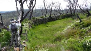
The featured image is a picture of Looking into the Empress Sluice Gully at 9Mile Diggings from the Tail Race. The Tabletop Track goes across the top end of the Sluice
More pictures on Google Photos
15 – 18 March 2021 – Four & & Eight & Twelve Mile Diggings & Giandarra (Kiandra Trip 20)
Purposes
Firstly thank to NPWS Tumut, Ranger Elouise Peach who so kindly allowed me to drive into the park by way of Mt Selwyn and park at the junction of the Tabletop and Four Mile Hut tracks.
This was a 4 day driving and walking trip to and around 9Mile Diggings, then back and down to Four Mile Creek Diggings and finally Giandarra and 12 Mile Diggings. The weather prediction for later in the week looked ominous and it turned out to be accurate. I walked 43.3Km over the trip.
This was all within Kosciuszko National Park just south of Kiandra along the Snowy Mountains Highway. This was a continuation of many similar trips to 4&9 Mile Diggings since 2011 and in particular my last trips Kiandra Trips 17 of 2-5 October, Trip 18 of 1-4 Nov and Trip 19 of 25-29 Nov 2020 (with David Scott).
The aim was to check on several issues with David Scott’s report on 9 Mile Diggings of Jan 2021 mainly involving various races, a dam as well as to try and locate some of the hut sites David has identified as being near Bells Tunnel area. I also wished to re-verify my 2011/12 finding that a main race next to Tabletop Track north of 9Mile Creek actually started at the source of Broken Dam Creek and not from a Bloomfield Ck tributary like many of the races that went to the southern 4Mile area. I also planned if time was available to check out some unusual races north of North Bloomfield area, check the ANC tunnel at Giandarra as well as the race from the B&D Tunnel at Giandarra that goes around to Garden Gully and onto New Chum Hill area. Lastly to revisit the 12 Mile Tunnels and look for a hut site near these.
Note parts of this post will seem chatty. The original document was directed at David Scott and I have not edited all these comments.
15th Mar- Day 1 – 9Mile
I did leave Canberra a little later than expected i.e. 7.15AM on Mon 15th Mar and reached Mt Selwyn around 10.15AM. There was no barrier across the Kings Cross access road and I was able to use the key supplied to open the gate at the mobile & radio tower site, although it was a stubborn lock that didn’t seem to wish to relock after I got through the barrier.
I drove along the access track towards the Tabletop Track although the grass was very high especially in the middle strip between the wheels tracks. Travelling down the Tabletop Track itself was fine. After parking at the junction as planned, I headed south along the Tabletop Trail and didn’t really stop until I was just above the first Milkman’s Creek crossing where I stopped for a quick lunch.
I then looked at my new Osprey Exos 48L Pack. I had it a bit over filled and maybe over weight and that included a day pack on the top. Just before stopping for lunch the chest strap broke, or so I thought. Looking at it after lunch I realised that it had not broken any plastic buckle as such. A little plastic connector that actually slides up and down was sewn in frame on the sternum strap. With about 25 attempts I was able to slide the little connector back on and there it stayed. I made sure not to slide it too low again.
I stopped at the top of the last rise and dropped my pack and wandered around looking for some extra races David had shown to be on the eastern side of the Tabletop Track. Well he was right or partially so. I found some small ruts north of my position and wandering down to the south east I came across a substantial race that turned out to be connected to the race that starts at the source of Broken Dam Creek and comes north around the great Divide plateau and drops down to Milkman’s Creek and then continued along near Tabletop Trail before crossing it and traversing around a Westerly ridge before emptying into Dams 2/3 or the Small Sluice Gully near Gold Hut site. This now meant that there was a junction right where it crossed the Tabletop Track with another leg now going down to 9Mile Creek. I didn’t labour anymore on this at this time and made a plan to revisit the area later.
Going down the track towards 9Mile Ck I dropped my pack again and went slightly west to see if I could pick up a hut site we had found there, so I could drop a further 20-30m below it and gps some items David had noted last year but neither of us GPS’d the site. The grass was so heavily grown that it was hard to identify the site. Certainly if you didn’t know was there you would never have found it. I found the site I think and was able to photograph a piece of metal & some porcelain pieces. Its labelled Metal & Porcelain (Pic 1030897) GPS UTM 55 H 633578 6019500.
I stopped at 9M Ck and checked along north bank of 9M Ck for a race coming from Dam 1 (my old Dam 8) along the north side of 9M Ck and heading west towards Gold Hut area. I even went up the hill and west of the main track and then wandered back down to the main crossing. No signs of any race.
I continued across 9M Ck and through the 9M Village location and then down a slope to an open area where we had previously found, 9M Site 19 gh fireplace modern, GPS, 55 H 633364 6019031. I think in the past this might have been a 9M digger’s hut site. The site was a fairly flat and not totally inundated with thick grass and weeds. I made this my camp for the next two nights. Water was only 120m west and there was some wood on a sloped ridge only 40m to the south. I laid out my tent with the door on the easterly side expecting any bad weather to come from the SW around to the NW. Yet for the next 4 days all the wind and rain came from the NE around to the SE.
I then went south over the saddle between 9M valley and the Scott’s Gully’s valley. Initially I traversed along a low ridge to the west side to reach a Dam I had known as Dam19. (David has it shown as 9M Dam8). I then looked around and followed another race from south of the Dam down towards Dam 21/22 (David has them shown as LSG Dams 2/3). However the race did not go all the way towards these dams or the LSG Sluiced Gully as David has shown. The race actually goes across the top of a Small Sluiced Gully and finished in another parallel Small Sluiced Gully. Both these gullies join together and the tail goes down further to end in a Tributary of Scott’s Gully. The race only travels around 100m from a small dam that sits directly east of the two parallel races that start near Dam 19 and go down past Dams 21/22 before splitting and going to Skeleton Ck and 9Mile Ck. I assume the two races fed the small dam which I labelled 9M Dam 39 Little Dam, GPS 55 H 633499 6018501. Pic 1030899.
I then walked down the two parallel races and followed a race that broke away from the lower race and fed into the north east end of Dam 21. I then walked back up along the small LSG Sluiced Gully but could find no race feeding into it as David’s map shows.
Around Bells Diggings
I then returned to the small dam and cut across the top of the Scott’s Gully Tributary valley and to a ridge overlooking the Bell’s Diggings and tunnel. I took some pictures again as it showed the various Lette’s and Bell’s mullock spoil heaps quite nicely. These are pics: Bells 1030901, 1030903 Lettes 1030900, 1030902.
I also looked around the west side for Bells Hut 6 as David has it labelled. Think I had it labelled as 9M Site 2 or 7 in the distant past.
I also visited Bells Hut 5 Empress Hut/Camp 5 (was Site 66 GH) (DS pt) Pic 1030905, 1030943 which we had seen in Nov 2020.
Also visited Bells Hut 6 poss site1 small flat site GPS 55 H 633732 6018609. Its small area underneath a dead tree. Pics 1030906-07.
That’s night was fine at the camp site but by morning it had turned very damp and foggy. I had done around 9Km on Monday, some of it not gps’d.
16th Mar- Day 2 – 9Mile Northern Sluice Gullies (NSG)
I decided to check out around David’s NSG i.e. Northern Sluice Gullies as my plan to check out around Bells Hut 1, 2, 3 and 6 would require fine weather, and it was anything but fine with minimal visibility. I was able to cross 9Mile Ck and headed up between two sluice gullies to Gold Hut again. My intention was to verify David’s latest maps that show a race coming around from his Dam1 (my old Dam 8) to a NSG Dam 4 and no direct race to Dam 2.

I started at the northern side of the circular Sluice Gully ‘NS Gully C’ and was able to follow a main race northwards and up until I found a junction with another race on the left. I however continued up the main race looking for any Dam or other connections until I was 100m north of the Sluice. I then left the race and walked east and down the hill looking for any races until I was nearly at 9Mile Creek. Not finding anything I returned by a slightly lower route regained the main race and returned back to the junction. This had now, with the previous day’s survey, confirmed for me that there was no race coming from Dam 1 around the hillside to near Gold Hut site.
I then went up the other race which lead me to a small low level sluiced gully area. From its top northern end another small race came down and soon rejoined the main race again. I then headed west across open grassy ground looking for any other races and ended up on the main race that comes down to Dams 2/3.
I looked for any signs of a race going from Dam 2 to the Sluice C but found none. However there is one race going from Dam 3 across to the top of the Sluice C with a breakoff race going around the west side of the Sluice. There is also another breakoff race going down to the Sluices A & C which David’s diagram does show.
I then went up past the small low level sluice and west to pick up the main race from Dams2/3 and continued up mostly in the race. This part of the race is not shown in David’s Maps. However I assess this race portion being the main race from Milkman’s Ck and Broken Dam Ck as its continuous, well built with no 90 degree turns. Reaching the top of the ridge I passed the junction with the leg that goes down to Sluice C. It connects at 90 degree so I assumed it’s the lesser of the two down legs. I followed inside the race (yes it’s mostly walkable with fine dirt in its base and of course the odd fallen burnt tree across it to keep explorers awake. It also makes for good nature breaks).
Tabletop Track Junction of Races and Races down to Nine Mile Creek and on to the main Diggings
I crossed the Tabletop Trail where I now realised that this spot is actually a junction for multiple races. David shows this a bit. The main source race comes down mostly parallel to the Tabletop Track and at this spot breaks into I think four races. One to Dams 2/3 & NSG Sluice C, one down the west side of the Tabletop Track and across it and down to NSG Dam 1 (DS) (or Dam8 GH), and two races initially side by side but later far apart down to 9 Mile Ck. There is also indications that another race went across Tabletop Track around 90m north of this spot.
David does show most of this but it’s not quite accurate.
I went down the first race towards 9M Ck. (David has it labelled as Bloomfield-9M Race 3) which really should be Broken Dam Ck-9M Race 2 and followed it right to Pt 145 (near 9M Ck) then wandered into the various bits and pieces of 9M Ck and actually got very close to Pt 202 where I was later coming from the 9M Diggings side. However everything after Pt 145 is ex race and part of the creek system. I then went up the creek system but further to the north to try and pick up any higher race. I then hit a higher race at Pt 147. I then turned south on this race hoping to follow it through to 9M Diggings. I did follow a race a short distance then walked across lots of grass and some rocky sections to be nearly across 9M Ck. I could not find any definitive connection across 9M Ck for this race. Tracking back north I realised the last part of any discernible race was flowing actually north and downhill as there was some water in it. I worked out from where the water was going that the actual flow was down from Pt ‘Race goes down in ck to 9M’. It’s a sort of a rough rocky creek heading down towards the lower end point Pt 145.
Further checking later convinced me that this higher race put water into 9M Ck and it joined with water from the lower race or just went down 9M Ck to the various dams below.
I then went north along this latter race and followed it to right to that concentration point on Tabletop Track ie Pts 40/118. I had some trouble in a couple of places as it went through a lot of dense grassland. (David has it labelled as Bloomfield-9M Race 2 which really should be Broken Dam Ck-9M Race 1).
I also went east and back to a Hole I had found the previous day. It’s a hole or a shaft ‘9M Hole Gh1’ GPS 55 H 633440 6019384. It’s around 2.5m diameter and 1.5 m deep.
I also went north along the main race and a little north ie 80m it does a dog leg to the right or east but then continues north but moving slightly way from the Tabletop Track. I did walk it on day 1 but my track didn’t record this. The various pts 003, 004,005, 016 to 023 represent this race. It’s quite large in places, i.e. deep and wide.
I note that David had some races on the east of the main race. I note and found some very thin and shallow ruts around here pts 24 to 30 that show the area of these ruts. However they were not significant and didn’t seem to represent serious races. I did walk across the plain looking and could not find any connection to the main races. These might have been part of earlier horse trips.
I did work out that the dog leg mentioned earlier is probably where they sent water down to reach that Milkman’s Creek race that we could not work out where its water came from. There are signs across the Tabletop Track that water may have flowed down a wide small trough in that direction. I didn’t check it out past around 75m. I think you could replace what you have for a possible race down to the Milkman’s Ck with this option. See pts 7, 8, 10, 12, 13, 14, 15.
I then went down to 9M Ck and had lunch sitting on the concrete wall of culvert. Of course two 4WDs equipped with weed spaying gear came down and interrupted me. They were spraying thistles along the Tabletop Track and later the 4Mile Track. They were contractors from Adaminaby. I asked them about Paddy Kerrigan and they thought he was still at Old Adaminaby although he had tried to sell his house some time ago. Later that day and the next I noted their wheel tracks going up across a race and onto the top of the range.
I then went up the south side of 9M Ck to check out races crossing to the diggings. Initially I went to the old wood stove and was attracted to some glass and porcelain pieces nearby. I gps’d them. ‘9M Site 79 GH Porcelain & Glass near Wood Stove’ Pic 1030916 & 17, GPS 55 H 633614 6019386
I then went up and came across a race that I followed upstream. However it ran alongside the creek area and turned into a defined race running at the same level as the creek right up to around pt ‘Cks join flow on as race’ GPS 55 H 633766 6019400. I continued walking up the creek for 55m alongside what were several creeks each of which seemed to split. I noted some legs on the right, ie south side, actually went underground into the large grassy area. I turned around at pt 202 which is nearly the same spot I got to checking out an earlier race coming from Milkman’s Ck and/or Broken Dam Ck.
I returned back down the race and followed it right into the main Diggings, There was one race coming from higher up and crossing this race and heading into 9M Ck. A tail race I assumed. There was another race that broke off and headed down west across Tabletop Track and to the plain below it. I continued on the main race and crossed the Tabletop Tk and followed the race for around 225m until it end just past pt 226 in the main diggings.
On returning back to the north I found a small open area with a constructed rock wall on its west side which I guess might have been a campsite with the wall providing protection form the westerly winds. I labelled it ‘9M Site 81 GH Protected fr west campsite’ pic 1030918, GPS 55 H 633651 6019044.
I then headed up into the diggings looking for the higher race coming from 9M Ck. I gps’d some possibilities but they all did not work out. I found one that was prospective but after crossing the Tabletop Track it headed down towards 9M Ck. So I went up and down the track looking for any possible race crossing it. I then went north over the grassland and deviated down and up the creek alignment 100m or so looking for any race. Finding nothing I then headed north and found the spots I had visited earlier on the higher east race from the morning. I then accepted that this higher race didn’t continue across the creek so I headed up the hill to the east around 160m and picked up another higher race that comes from Milkman’s Ck although David labelled it from Bloomfield Race 1. (David you should label it Milkman’s Ck-9M Race 1).
This race is different to the earlier races as it does cross 9M Ck area through a 70m long embankment across the creek valley and then continues on as a race to cross Tabletop Track and enter the Upper Scott’s Gully diggings finishing at pt 248. This is not shown on David’s maps.
I returned to cross the embankment again, then I went up hill to the east keeping to the north side of the creek area in case any more races came down from the plateau above. I then centred myself on the overall ck and in the process I missed the highest Intake Weir which feed a race going over the top of the Tabletop Track and feeding the uppermost section of Scott’s Gully Diggings from the east or top. From what I have seen David has shown this correctly.
Over the Top of 9Mile Ck and Race from Upper Broke Dam and around to Milkmans Ck and Tabletop Race Junction
I then went right over the plateau seeing what condition 9M Creek headwaters were in. There was certainly no water lying around and the ground was not soft. There was considerable coverage of grass and various weeds including some thistles. Around what is probably the real source are quite a few dried up stone ponds which would never be very deep. I ended up reaching the 4Mile Track and walked along it for 50-100m before turning north-west to head towards the source of Broken Dam Ck. On the way I crossed several dried up bare earth areas covered with various coloured moss and lichen. Pics 1030921-1030923. Some of this was quite beautiful and certainly colourful. My pics do not do it justice. I then dropped down into the valley that contains the source of both Broken Dam Ck and Bloomfield Ck although the later has numerous tributary sources along the Great Divide Ridgeline until the old Commissioners Gully Track is reached. While the source of the race is most certainly Broken Dam Ck, Bloomfield Ck also has a tributary starting from the same valley but slightly further to the north and a little downhill of Broken Dam Ck.

I found the north end of an embankment or weir that goes right around the western end of the valley collecting water for a race that starts at the pt R545 (old pt). I used an old point from 2011-12 as I missed out following the full length of the embankment. However from near this point I was able to follow a race, mostly walking in the race, but occasionally losing it for a few metres or so until around pt 279. On the way I did note that the race was benched into the side of the plateau for some distance and the race overlooked the Bloomfield valley that was directly to its east and north-east and a long way down. Most of these points are new but I have a set of older points for the whole race to Milkman’s Ck and on. I regained this race at pts 280-282 as it reached Milkman’s Ck. My other track points around here are not on this race exactly. Milkman’s Creek is fairly thin but deep and very heavily populated with very tall grass, the thick stuff. However I was able to push through and regain the continuation of the race which I didn’t follow far as I have previously GPS’d this right through to its crossing of Tabletop Track. In another gpx set for tracks I have include older points to give you a full set from Broken Dam right around to Tabletop Track and links on to 9M Ck and also NSC Dams 2/3 and NSC Gully C near Gold Hut site.
On the way down from the plateau above I had cut south stopping on the edge of the plateau to climb onto a Rocky peak for some views which were quite good out over 9M and right out west to probably Round Mountain or Dargal Mountain.
I went down from the peak to the northern end of the race which I suggested be labelled Milkman’s Ck-9M Race 1. It’s very grassy but certainly doesn’t go any further than the old gps data showed. I think the race is really starting from the headwaters of Milkman’s Ck. I did note some minor trickle flowing in a creek below the race start area. If I had gone straight down I should have ended up in Milkman Ck for sure. I however wanted to pick up the other race again.
I returned down the Track and through the 9M Village to my campsite for another cold misty night. I had walked 14Km this day.
17th Mar- Day 3 – Nine Mile – Bells Diggings, Four Mile Area
I got up to another overcast and cool day with some mist around. I decided to go down and look at the Bells area again as well as trying to locate the Bells Huts 1-3, then return for lunch and packed up and headed to 4Mile Ck area.
On the main route down to the Main Sluice and Bells I decided to take some pictures to show the context of the surrounding hills and valleys as it might prove useful in locating the actual old huts shown in some very old early 1920 photos. So I took a couple of shots from high up the valley. 1030928 shows a close up of the area I was going first, the hill to the west of Bells Tunnel workings. Then I took another 1030929. This one was taken from pt View south Pic 1030929 GPS 55 H 633647 6018818 which is not a close up. Then I reached a site I named ‘9M site 75 GH no mound’ GPS 55 H 633663 6018737. It’s an open site on the top of a small flat knoll with lots of stones but real mound. It has some broken glass and the site is around 6m x 2.5m overall. Pics 1030930-32.
I then headed down to the edge of the plateau overlooking the swampy land below and tracked around until nearly level with Bells Hut 4 and found a small pile of rocks in an area west of Bells 5. It’s an area of 5x2m, named it 9M Site 76 GH, GPS 55 H 633691 6018665. pics 1030934-37. It has a small dugout area behind the mound with a layer of rocks layed behind that.
Bells Hut 6 poss site2 GH GPS 55 H 633727 6018623. Pics 1030961-62
I then went across to the east side of the gully and looked around David’s positions for Bell’s Hut/Shed 1-3 which all seem to now be located right on the edge or in the swamp formed by the Settling Dam. However I was able to walk to all sites as well as further north to what I thought was more solid land but was not. I could also walk to the end of the tail race without sinking much. At all the sites I took pics but could not see any evidence of any human habitation at these sites.
Bells Hut 2 seems to be in the swamp, Bells Shed 3 under rock piles from Lettes area. Bells Hut 1 looked to be on the most sloped land although close to rocks and mullock piles. There were lots of Mullock piles all along the edge and just above the hut sites
Bells 1-3 site pics: Bells 1 Pics 1030954-55, Bell 2 Pics 1030956-57, Bells 3 Pics 1030952-53.
I then went back to Bells area. Pic 1030959 shows that there are two mullock piles on the west side of the Gully.
Pic 1030960 shows the dam just up in large field and south of Bells Tunnel. This was my Dam 12 and from what I remember I think it only fed the Bells area. There was a race coming down from the creek to the south that went high above the dam and came around to join into a major race coming down from high up the hill to provide water for the Lette’s tunnels. I am sure the sketches I did show that clearly. You maybe need to add a weir on the creek that shows this race. I re added and made comments in a sketch for this area.
I then returned across the gully and looked again around the slopes for more sites.
I found a site ‘Bells Hut 6 poss site3 bit rocky GH’ GPS 55 H 633733 6018632. Pics 1030944. 1030945 shows Dam below.
Bertie Bells Hut 4 site (DS pt) GPS 55 H 633727 6018670. Pics 1030963. Shows site heavily grassed and with Mint growing.
9M Site 77 GH GPS 55 H 633681 6018665 Pics 11030964-65. Site with small mound and a flat area behind it.
9M Site 78 GH mound rocks GPS 55 H 633675 6018664 Pics 1030966. No dug out land.
I took three pictures from the hill to the west overlooking Bells area to create a single panorama and this is included in the picture album. Pictures involved were 103 0939, 40, 41 taken 15 Mar.
I returned to my campsite, had lunch and packed up the tent etc.
Travelling to 4Mile I went back through 9M up the Tabletop Track to the crest of the range and then walked up towards the top passing that race twice and to Cairn 3. I then tracked down to Cairn 1 and then north west through some thistles, open thick grassland and then down semi grassland and down some of the old Commissioners Gully Track, that I could see some sections of, towards 4 Mile Sluice. I GPS’d quite a few spots so now have a pretty good gps record of the trail in this area. I also could see the race coming down from a Bloomfield tributary heading for 4M Sluices A&B.
I eventually came to the top of the main 4M Sluice A (Pic 1030967). I then walked down the eastern side of the Sluice passing two Sluice Miners Hut sites and then Glennies Hut site which was hard to find with fallen trees and thick grass.
I then headed across the wide open valley to reach the burnt 4M Hut site only to find a father and his daughter ensconced there. They were happy for me to join them. Before putting up my tent I went back east and tried to find a hut site 4M Hut Site #7 that comes from Paddy Kerrigan’s map of 4Mile Area. I went nearly to Bloomfield Ck through lots of thick grass and weeds and once again failed to find the site. The area was heavily grassed.
I returned to camp and cooked dinner with the others. They were Albert Alonso and daughter Alesandre from Sydney. They were walking the AAWT from Blue Water Holes though to Whites River or Dead Horse Gap depending on the weather. They had inserted food drops in large storage containers at Dunns Hill (near Kiandra) and near Whites River Hut. They had intended to leave the Dunns Hill container at 4Mile Hut but of course the hut was no more. Their next target was Happys Hut which I told them was also no more. I had walked 9.8Km this day.

18th Mar- Day 4 – Giandarra Diggings, 12 Mile Diggings
We were up early and packed up wet tents etc. It had blown and drizzled all night but luckily not much in the morning. Pics 1030968-69
At the junction of the 4Mile Access Track and the Tabletop Track we parted company. I gave them a packet of freeze dried food and some bits and pieces I had spare. They gave me some rubbish and their 25 litre storage container to take out. I wished them well. They did get to Whites River Hut and spent a full day there as the rain pelted down. They then got out at Guthega Power Station the next day.
I drove out and stopped on the Snowy Mountains Highway near Giandarra. I then went up there with my day pack and some food and looked at the ANC Tunnel again. It was cleared by the fires but is now covered by thistles etc. However I could see that the tunnel entry had collapsed. I could also look down the defile that leads down from the tunnel and still see an orange layer of soil down there where the original spoil must have been. It’s now been flattened by time and probably SMA and SCA activities. I climbed up through the sluiced cutting above to the top dam and the race above and looked around the tops. Pics 1030970-73.
I checked out G-T’s site 503 and 504 which were nothing more than some stones pressed flat into the ground now. These sites are just above I think an SCA constructed rough stone wall that runs over the top of Luttrell’s site. The two sites sit right at its northern end of the wall. Pics 1030974-75
I then headed south to the main still existing real mine site which David has labelled the B&D Tunnel dating from the 1930’s. It’s tricky to access so anyone trying to emulate me should take care. I went down from the top out onto the two mullock heap wings but went down the south one and hopped over a small creek that flows down from the mine. I think water flows from high up, probably one of the tunnels and on its south side and into the grassy area below. I walked south through lots of grass and climbed up to join a race that I always thought came to the site, I suspected from Garden Gully around to the south. Pics 1030976-77.
I thought for all money that race was coming down to the mine. It still looked like that for me. So I started walking south in the race which wasn’t always easy because of thistles and thick grass. As I went I took GPS waypoints and looked at each to see the altitude. I took 11 readings in 660m. Initially the altitude was 1403m ending at 1400m. Not much change but typical of well-constructed race that usually has a gradient of 1/144, created by a 1” drop in 12 ft metal chain. From the last point I could see well into Garden Gully and see 2-3 races continue around it on the other side as well as two tracks higher up. These latter were SMA roads they use to extract granite and sand during the construction of the Snowy Mountains Scheme.
So I have to state to David that I now think I was wrong and Gant-Thompson was right. The race probably took water coming out of the mine around the New Chum Hill area. The Giandarra mines were apparently renowned for the water in the tunnels. Pics 1030978-79.
I returned towards my car and stopped for lunch on a bare inhospitable landscape that is below the Lutrell’s Mine area. However I did find two items.
SMA likely anchor, GPS 55 H 634258 6032073, Pic 1030981
Electrical Isolator Labelled ‘Made in Occupied Japan’, GPS 55 H 634395 6032112, Pic 1030982
The latter is very interesting. It has 48 also on it so maybe it was made in 1948 just after WWII. Might have been used on an electrical circuit or comms line of that period.
I then went north and parked opposite the Exit road for the Yarrangobilly Caves. I then followed a dirt trail that leads to high tension 330KV power line towers that run along the valley which also carries Carroll’s Creek. The areas sits on the Fiery range. Across the other side other valley and creek there is a ridgeline that runs north south along the west side of the Murrumbidgee River for around 3KM. On this range there were some diggings which are known as the 12Mile Diggings. I thought a large open cut at the northern tip overlooking the Murrumbidgee River was the real diggings and there was a tunnel inside this large cut out section. David has told me he now thinks it was landslide. On the way back several years ago I decided to walk along the river side of the ridge and low and behold I could see a mullock high in the air sticking out from the ridge around 0.75Km south of the place I had been. That’s how we discovered these tunnels. To be fully truthful I had heard from a guy from Batlow who took his horses to ride around from Bullocks Hill Horse Camp that he knew of a mine along the Murrumbidgee River. Thus I had a second reason to look along there.
On the way to 12Mile I left the track and looked for William Cahills Hut that I had plotted from the Lease plan as GPS 55 H 637900 6043582. There was also Reef Mine nearby Cahills Reef FieryRangeMine DS GPS 55 H 637980 6043610. I looked for the hut site although the grass was quite strong but walkable around. Instead of the hut or mine I found 12M Site 1 GH Cahills Rubbish, GPS 55 H 637979 6043595. It was a large rubbish pile with a huge amount of brown beer bottles all labelled Property of the NSW Bottle Coy. Of course they were all smashed. There must have been nearly 100+ broken bottles. The NSW Bottle Coy was formed in 1916 by both Tooths and Tooheys. There was also some metal pieces that may have been used for a frame or similar devices. For some reason I can’t explain I didn’t look for the Mine. Pics of the rubbish 1030983-84. In the process of looking around a copperhead slid away from me.
I then headed out over grassland and went passed a tower, down to the creek and climbed up onto the range to the east. In this process another copperhead slid away from me. That slowed me down.

On the top I was gifted with a great view down South east over the Murrumbidgee valley. Pics 1030985-86. I then headed north along the ridge which was easy going for 400m after which I had to drop down slowly and the first thing I found was 12M Shaft GH, GPS 55 H 638989 6043863. Pic 1030987. My reading was adjusted 5M NNE to put the reading I took on the edge into the middle of the pond in the shaft’s hole.
My GPS stopped recording a track around here for a short period. However I did try to find David’s other mines and mullock points, noting he had 1-4 for each and a second shaft. I found it hard as the area is steep, the scrub is now awkward, with some blackberry plants, and lots of thistles around sometimes in strong thickets. I did see another hole, maybe a wombat one, which might have been taken as tunnel. However I GPS’d the two most prominent tunnel/mullock combinations which were the two I saw before.
12M Tunnel 1 GH, GPS 55 H 639044 6043840. This is equiv to DS 12M Tunn1 Murr Mine1, 55 H 639043 6043841
12M Mullock Heap 1 GH, 55 H 639059 6043831, Pic 1030988. Equiv to DS 12M Mullock heap1, 55 H 639062 6043835
12M Tunnel 2 GH, 55 H 639092 6043805. Equiv to DS 12M Tunn4 Murr Mine2, 55 H 639091 6043806
12M Mullock Heap 2 GH, 55 H 639103 6043802, Pic 1030990. Equiv to DS 12M Mullock heap4 (DS), 55 H 639106 6043802
I also GPS’d another item but it was not perfect due to the scrub
GPS 1 12M Mullock Heap 3 GH, 55 H 639035 6043824. Equiv to DS 12M Mull2, 55 H 639037 6043824
I did not take pics of the mine tunnels as they were all collapsed and were mostly covered with grass and thistles so photos were essentially meaningless.
It didn’t stick around as it was getting late and I planned to get home that night. I returned OK to the car and was home soon after 7.30PM. I had walked 10.2Km this day.
Addendum
Later I contacted Albert whom I had met at 4 Mile Hut site. He updated me on his further progress on the AAWT south. It was very unfortunate for them that they were walking in a period of cool and wet weather. It was the time of the great flood that engulfed a lot of the coastal region of SE QLD and Central and NE NSW.
“Hi Greg – Thank you so much for your photos, taking our rubbish + Food Bin, extra Food + sharing your company and knowledge of this incredible area. Yes – mainly strong Easterly winds + misty/drizzly rain after we left you. Jagungal was hiding in a blanket of cloud – we did not go up. We were lucky to cross Geehi River before the heavy rain dropped on Day 11 – I assume it may have been impassable for a period of time after we crossed as it was hip deep and flowing+++ when we crossed it Day 10.
Eventually, the weather won as we sat out Day 11 at White’s River Hut with heavy rain and the wind warning for the high country mean’t it was imprudent to continue.
We had a wonderful trip.
Thank you again for your support.”
Their AAWT Walk Day by Day
Day 1 Blue Water Holes to Bill Jones Hut 8km
Day 2 Bill Jones Hut to Hainsworth Hut 12 km
Day 3 Hainsworth Hut to Murrumbidgee River 14km
Day 4 Murrumbidgee River to Chance Creek 17km
Day 5 Chance Creek to Four Mile Hut 13km
Day 6 Four Mile Hut to Barney’s Creek 23km
Day 7 Barney’s Creek to Mackay’s Hut 10km
Day 8 Mackay’s Hut to Derschko’s Hut 17km
Day 9 Derschko’s Hut to Grey Mares Hut 10km
Day 10 Grey Mares Hut to White’s River Hut 19km
Day 11 Washout with 40-60mm of rain – Rest Day @ White’s River Hut
Day 12 White’s River Hut to Munyang Power Station 8km (Severe Weather warning – 100km/hr winds > 1900m – Walk terminated early)
Diagrams, Pictures and Docs Available
Pictures are grouped into bundles for each area:- i.e., 4Mile Area, 9Mile Area, 12Mile Area, Giandarra and a couple of miscellaneous pictures.
Google Pictures (Google photos album has 98 pictures).
All document, gps and sketch files are on Google Drive
GPX Files – There is one main gpx file and another with Tracks such as Roads and Races:
- Kiandra20 15-18 Mar 2021 which covers all my trip plus includes some old data and several old tracks for completeness
- Kiandra20 15-18 Mar 2021 Tks which shows most of the above but extra tracks to show derived tracks and some old tracks section for completeness
Excel Files
I did not produce any excel file. However there are about 27 sites mentioned in the text of the main word file that includes name and gps readings.
Trip Maps
I did produce 7 trip maps using Oziexplorer with NSW topo base. These maps show overviews of various areas and relevant tracks such as management trails and water races
Sketch Maps
I have done 9 sketch maps all in the 9Mile Area, each with a jpg and pdf version, covering:
- Around Dam2/3 and various connections to NSG Gully C as well as no race to Dam 1
- Tabletop Trail Milkman’s Ck to 9M Ck and on wards as well as to Dams2/3
- Race Broken Dam to Milkman’s Ck and on. I show more detail on the confused crossing of Milkman’s Ck
- Dam 19 (DS Dam 8 9M Ck Area) down to Dams 21/22 LSG Dam2 with some changes and a small dam
- Bells area races & Dams updated and older sketch. Note there is no race through Dam 12 (GH) or Lettes Dam7 as you have shown
- More detail on races down to 9M from north Tabletop Track junction point where several races branch as well as those races reaching 9mile Ck where the races reach the Ck but don’t continue directly. And more detail on higher race that does have an embankment across the 9M and continues into Upper Scott’s Gully
Whilst these are sketches they mostly are based on underlying gps readings and gps tracks at various scales.
Sketch Maps List
- Sketch 9MRaces 9MDam8 to DamLSG2 GH 1Apr21.jpg & pdf
- Sketch 9MRaces to GoldHutArea GH 1Apr21.jpg & pdf
- Sketch 9MRaces & Dams around Bells updates GH 1Apr21.jpg & pdf
- Sketch 9M Sites around Bells visited GH 1Apr21.jpg & pdf
- Sketch 9M Races from Tabletop Jn to 9MCk & on GH 1Apr21.jpg & pdf
- Sketch 9M Race Upper Broken Dam to Milkmans Ck & 9M Ck GH 1Apr21.jpg & pdf
- Sketch 9M Race Milkmans Ck to Upper Scotts Gully over 9M Ck GH 1Apr21.jpg & pdf
- Sketch 9M Races from & through Milkmans Ck to 9M Locations GH 1Apr21.jpg & pdf
- Sketch 9M Races through Junction on Tabletop Tk GH 1Apr21.jpg & pdf
Some Requested Revisions of David Scott’s Report and Maps
Note the comments below are personal comments meant for D Scott but I have included them to be complete. They would mean nothing to anyone else.
9M DScott’s GIS Jan21 Maps to be Updated
One pdf file was done with manual highlighted updates to 4 map pages: number 5, 8, 14, 20. These are hard to read as an A4 version was updated and scanned and compressed. The file name is “9M DS Maps 5 8 14 20 Updates GH.pdf”
Maps to Update from 9M DS GIS Maps 16 Jan 2021
Page 3 Update Bloomfield 2 & 3 Races. No 2 has no extension south. No race D2 to Sluice. There is a race from D2/3 direct to TT Tk. Page 5: -Update Bloomfield 2 & 3 Races. No 2 has no extension south. Delete race NSG Dam 1 to Dam 4. No Dam 4. Doesn’t show Dam2 2/3. No race D2 to Sluice. There is as race from D2/3 direct to TT Tk. Doesn’t show race extension from Bloomfield 1 Race into Upper Scotts Gully area. Race is from Milkman’s Ck area. Page 8. Same as P5. Page 11. New huts possible near Bells 4. Page 13, 14 Add race across from Bloomfield 1 Race into Upper Scott Gully area. Race is from Milkmans Ck area. Page 17. Its shows Lettes Dam 7 (My old Dam 12) as having a race through it. Not so. See my sketch on “Dams & Races between Header Dam & Bells Diggings on Scotch Gully” See pic P1030960 Dam Lettes 7.jpg. It shows that whilst dam is wide it’s quite thin and race across the top is well above it. It was feeding Bells area so maybe the name should be a Bells Dam ?? Maybe you should have another Bells Dams up on the creek where the race comes from as well. Page 20. Race from Upper to Small Sluice Gully next to LSG Dam 2 wrong. Start point is small dam next to dual race. Race finishes at two unshown small gullies that join and tail race out east to creek. Pages 21 22 Need review as there is a connection down to Milkman’s Ck from Broken Dam Ck Race. Marked up Versions are on drive for Pages 5, 8, 14, 20.
9M Survey Prelim Report
I haven’t gone through the site spreadsheet nor the prelim report in any detail. Just too much to look at. My thoughts are it needs a nice index as it just seems to scroll on and on. I know it’s broken into functional areas. I did notice a comment in the text or diagram where it had the eastern outlet of the Empress Header Dam receiving water from Bloomfield Ck again. As we now know the outlets from that header dam go west on either side of the Track to the Upper Scott’s Gully area. It’s on page 64 of 94 of the report and it’s in the Items 4 & 5 area Outlet Gate West & Outlet Gate South. It’s in the “Empress Header Plan. Sketch site Plan DS 2020” l note it says in top left “Race in from Bloomfield”. Thats a double bomb out as originally you used to say it came in from upper 9Mile Ck. It should be ‘Race Out to Upper Scott’s Gully area’ or similar. The maps covering that area are correct. It’s just the sketch text that is incorrect. I might have some photos for the required images 4-14 as noted on the Report page 64 above.
WordPress Post Categories and Tags:
- Post Categories: Walks, Kosciuszko NP, Kiandra Walks, Mining, Mountains, NSW, Huts, AAWT
- Post Tags: Tabletop Trail, Gold Hut site, 4 Mile Diggings, 9 Mile Diggings, 12 Mile Diggings, Scott’s Gully, Upper Scott’s Gully, Lower Scott’s Gully, 4 Mile Ck, 9 Mile Ck, Empress Sluice, 4Mile Sluice, Bloomfield Ck, Copperhead, Bells Diggings, Gold Hut Site, Broken Dam Ck, Giandarra.
Greg Hutchison, 4 April 2021


Excellent work Greg.