2019 05 01 Four & Nine Mile Diggings & Part of Arsenic Ridge (Kiandra 16)
This was a 5 days & a total of 65.1Km walking trip from Pollocks Gully near Pattinsons Lodge, Kiandra to 9Mile Diggings, then Tabletop checking out the Temperance Ck and Arsenic Ridge routes or tracks, and also trying to walk the old track to 4Mile Sluice from the Tabletop Trail, and lastly walking the last piece of the Gold Commissioners old track down to Pollocks Gully and the Commissioners Camp site. This was a continuation of many similar trips to 4&9 Mile Diggings & Temperance Ck since 2011
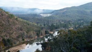
The featured image is a picture of the Main 9Mile Empress Sluice from near Header dam on Tabletop Track
More pictures on on Google Photos
27 April – 1 May 2019 – Four & Eight Mile Diggings, Temperance Ck Track and Arsenic Ridge Route (Kiandra Trip 16)
Purposes
The purposes of the trip were to check out races over the saddle at 9M, see what’s lower down 9M Ck, find where is the old track down from the top near the main sluice gully, to reconfirm 4Mile Sluice B layout, visit Waterhole Ck and look for a hut site, check out Arsenic Ridge and see if its walkable and if it can connect to Temperance Ck old track. Most of these were achieved except I didn’t get to Waterhole Ck and I only got about halfway down Arsenic Ridge.
Summary of Items of Interest
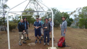
- Day1 – I walked out along the Tabletop Trail. Near 4Mile Hut turn off I met 7 members from Nordic Ski Club who were spending the weekend maintaining 4Mile Hut
- Day1 – I walked on to 9Mile Diggings. Then I followed a race from saddle between Scotch Gully and 9Mile Creek. I also saw a deer who made a noisy horn like sound
- Day2 – I walked up to the saddle to the south and into the Skeleton Ck Valley. I watched a fox hunting for food along Dam28 then searched for a possible race coming from Dam19 that might go back to the area near where I camped. I eventually found one with extra dams.
- I walked down 9Mile creek past a Slot in the creek as it turned into a mini gorge and continued down a little further.
- On the way back I found more dams right where I had camped, a hole into the bank, the fireplace site previously I had found looked more like a real hut site, I also re-examined Gold Hut site and routes up to it and tried to find the source of the race that comes down and through the saddle between 9Mile Ck and Scotch Gully. I cancelled going to Waterhole Creek and camped near the source of the Tabletop north race section.
- Day 3 – I walked down the old Temperance Ck trail route and walked down Arsenic Ridge to a peak SMA 397. On the way back I went more northerly near the old airstrip and re visited Tabletop Hut site.
- Day4 – I de camped and walked down the Tabletop Track to 9M. Then I walked down an old track close to the main Sluice Hole and I think I found the way to old village trail as well as a large hut site. I then continued along the Tabletop Track until I could walk down the Gold Commissioner old track to 4Mile Main sluice. The track was not visible so it was walking through a lot of scrub using the GPS. I got to the Sluice OK and then found Kerrigan’s 2nd Sluice Miner’s hut site and revisited Glennies Hut site. I later revisited the 2nd major sluice gully to verify my finds from previous trips.
- Day 5 – It was a cloudy morning as I packed up and headed out but it soon rained and I had to put on my rain jacket. I finished walking the old Gold Commissioners Trail direct to Pollock’s Gully as well as to the old Commissioner’s Camp site.
This trip solved for me the location of old tracks down to Kiandra and Gold Commissioners Camp. I also sorted out the race from 9M Dam19 as it certainly also went over the saddle and down to 9M Dams 31-33. I also worked out the race through the other main saddle just east of the village as a race certainly came down from Upper Scotch Gully and went down towards 9M Dams 31-33 and maybe 18. The questions still remain where exactly did the water come from for that saddle race and also where did Dam19 get its water supply. It’s possible I misread the race as there was a subsidiary race leaving that race crossing the saddle. It seemed to go down towards Bells diggings but maybe it stayed high and went to Dam19.
I also was able to determine that it’s possible to walk down Arsenic Ridge although parts of the Temperance Ck Trail that lead one to this ridge had become quite scrubby.
The weather in early 2019 had been quite dry so availability of clean water was not as easy as normal. However 4Mile and 9Mile creeks were still flowing. Temperance Ck and the main tributary near Boltons Hill Trail were both still flowing but were very shallow.
The following are notes on my 5 days trip. Some are detailed in regard to mining infrastructure such as races, dams, and diggings sites. Some might seem excessive work but learning where the water is taken from and where the dams are, leads to finding the actual diggings, sluice gullies and even mine tunnels. Many of the sites are in remote rugged country. Many races run through thick scrub and can be very hard to detect and follow. After a while you can work out where the races go and often only need to verify a sampling of the race locations with GPS waypoints. Sometimes they follow around large features like mountains and hills. Its often a treasure hunt to see if they follow contours or cut across a saddle or track to defeat your original thought as to where they were going.
This trip was one of many over several years checking mining and other historical sites around Kiandra to help historian David Scott and ultimately Kosciuszko Huts Association (KHA) with documenting European historical activities within Kosciuszko National Park (KNP). In the process many hut and mining sites have been found, GPS’d and photographed.
This was a continuation of many previous trips to both 4Mile and 9M Diggings including Tabletop, Broken Dam, Elaine Mine and North & South Bloomfield Areas going back to around 2011.
27th April – Day 1
I was up reasonably early & left home at 6.55AM, stopping for a paper then at Maccas Cooma for a break & coffee. Then I drove straight to Pollocks Gully, Kiandra arriving around 10.15AM.

I left about 10.32AM and headed up the Tabletop Track. As it flattened out I dropped my pack and walked across to the east to check out the old Gold Commissioners Trail as it split with one arm going down to the Commissioners old camp site and the main trail straight down to Pollock Gully. I simply walked a little of the last to see if it was viable for me to walk on my last day. I GPS’d some points and vowed to do it on my return.
Still climbing on the track I came across some pig diggings. The most astonishing section was part of the trail being totally decimated by pigs turning over the track. Quite unreal how they had dug up well used and compacted track.
On my way down towards the 4Mile turnoff I came across several people coming up from 4Mile Hut and then some more coming down from Mt Selwyn. This included Phil Griffiths from NSW Nordic Ski Club and 6 more of his members. They were spending several days at 4Mile Hut doing their annual maintenance visit. They seemed like a nice group of people of all ages. On the way down I stopped and showed them the North Bloomfield Sluice Header Dam which is 30m east of the trail but hidden by the vegetation.
I lunched on the trail at the 1st 4Mile Creek crossing and then continued on to 9Mile where I noticed NPWS had done some work clearing the track including adding a mixture of old bitumen and ground crushed rock to the track and removed some large fallen trees to the sides. This has made access to the old 9M Village track a little easier, although the scrub around the village area is now much thicker and more widespread. I went through the village area and to the saddle on the south side that separates the 9Mile Ck valley from the Scotch Gully valley. Here I walked west following a race that seems to transit along the length of the saddle. From the west end of the saddle I was able to follow the race that went high along the south side of 9Mile Ck valley. After 400m it eventually split with the left branch swinging south for around 200m where it petered out at a dried up small creek. Near here I was surprised by a large horn like noise and looking up I saw a large deer running away to the south. I returned to where the race split and followed the main one down for less than 100m and it petered out although I suspect it originally continued on to a creek below and either down to the creek diggings or to another dam I came across, 9M Dam 31. This is largely a long 150m wall with a midpoint where water can exit.
I followed this across and found an area that was suitable to camp at around 4.23PM. I was very close to another Dam 18 that I had aimed for. There was a bit of smoke around as they seemed to be burning off to the west somewhere down in the Tumut valley. Luckily the small breeze died off and the smoke dissipated. It was a cool but calm night.
I had done 14.0Km today.
28th Apr – Day 2
I was up early at 6.00AM and breakfasted on my stove. It was quite frosty. I packed up most of my gear but left the tent up to dry and put some essential items into a day pack and left around 8.25AM. I went across to 9M Dam31 again and then up the grassy valley to a saddle that separated the 9Mile Ck valley from Skeleton Ck to the south which is a tributary of Scotch Gully and which then flows into lower Temperance Ck.
Initially I headed towards 9M Dam28 which is at the top of Skeleton Ck. I saw a fox near this dam and stopped and watched him for several minutes. I was able to take several pictures but they came out slightly blurred. I then backtracked along the route of a race from that dam that comes from a large Dam further to the North East, 9M Dam19. After bumbling around in thick scrub I was able to pick up a race running along a line of trees that headed north-west to the saddle I had crossed. It was difficult to trace through this saddle due to thick scrub but eventually I worked out it travelled right through the middle and down the middle of the valley. As I got lower it was easier to track. It ended into two separate sort of sub Dams to 9M Dam31. I named them 9M Dam 32 and 33. The water would have flowed through both of these dam before entering Dam31 which is a wide and narrow type of Dam.

I then returned to camp and went down stream to the bottom of 9M Ck where it enters a small gorge and then a long 40-50m narrow rocky slot which I labelled The Slot which was quite strange. It is a long narrow rocky slit around 1.5m wide and 2-3m high and fairly straight with vertical rocky walls. I am unsure but it looks like a natural tail race. Looking at rocks all piled up along the north side and a grassy channel high up they may have been able to dam the gorge up the Slot and force water up and along the channel, enabling them to extract gold from the slot if they had sluice boxes in there. I went further downstream around 500m and could see further down to a nice grassy area where there were further piles of stones. I returned to the camp site but close to the camp I noticed two more adjacent dams 9M D34 & D35.
I picked up my real pack and headed east up 9M Ck valley. Near D31 I noticed a large hole in the side of the embankment between the ground level and 9M Ck level. I thought it was a wombat hole but thinking about it I had not seen many wombat holes around. It was quite large initially but seemed to narrow further in there. I could hear water dripping into the hole. The hole had a distinct small entry gully but there was a no spoil which you would expect if it was a miner’s adit and also a wombat hole. It could be heavy rain had washed any such mullock spoil downstream?
I continued upstream and re visited the Site 19 Fireplace which is located out in a large open area. Further examining it I think it’s a hut site as it has rocks to the west of the fireplace which then raise that area slightly higher and create a rectangular area with the fireplace at the east end. The fireplace is just some rocks rearranged into a round fireplace in modern periods.
I lunched near here and then walked across the plain and up to the Gold Hut site and the large round sluice hole to its east. I also tried to see if there was any track as per the SMA 1960-70s maps. There were some ruts running north from a small sluice gully that runs west of Gold hut site down and then out to the east to the main 9M creek. It’s feasible they could have use this gully and ruts up to Gold Hut site as a trail. I noted a tree near Gold Hut site has fallen close to the fireplace rocks making them hard to see and the continued grass and scrub growth made it difficult to see any iron pieces although I found half a dozen pieces and took pictures of them.
I went up to the main saddle between the valleys and then tried to follow a main race east up from the saddle but the scrub beat me and I had to drop lower down and walk up a wide area to get to the Upper Scotch Gully Mullock Heap and then up a small gully to 9M Dam16 then to the Tabletop Trail. I had ideas that I should look at the open area south of 9M Dam15 and see where that went, so I noted that as a task for Day 4.
I went along the Tabletop Trail past the mountain and then down to a saddle and turned east to try and find Waterhole Ck. I walked over a large dried swampy land and became worried about finding water and a suitable camp site. It was getting dark and cold. So at 4.52PM I turned around and raced back to near the Tabletop race takeon area. I put down my pack at a suitable camp area and found no suitable water at the takeon. I went downstream some 200m and luckily found a trickle of water. I got back to my campsite to set up my tent at 6PM. It was now a bit dark. However all was well.
I had done 15.4Km this day.
29th Apr – Day 3
I got up early a bit after 6AM and left at 8.20AM with my day pack and a plan to stop at 12PM, then have lunch and return in order that I would reach my campsite before night fall. Initially I walked along the Tabletop Track until I was 200m south of the tyre on a tree (that denotes where the old airstrip was and some people’s idea of where you could walk) and found a small cairn sitting on a wider rock. This denotes the start of an old trail down to Temperance Ck and the Boltons Hill Track and to Arsenic Ridge. It now is more of a route although in some sections old wheel and foot ruts can still be seen.
The initial 475m is across open grassy woodland (This is covered by GPS points TC Cairn and T1-T3. TC stands for Temperance Ck start point and Tx for Temperance Trail point no). After T3 and down to Points T5 and T6 it was quite scrubby, although some of it can be walked around if one is keen. T6 to T7 crosses a very large swampy section and a track rut can be seen in the north parts of this. I saw some 15 pigs cavorting around in this area way back in 2011 or so. From T7 it’s fairly easy if you stick to the east side of the valley and adjacent to the wooded ridge on the east. Around T4 I headed out onto the grassy ridgeline and followed it down to Temperance Ck with T10 being the creek crossing. This is good water, although further on a tributary of the creek may offer water.

From this point it was a short climb up the opposite bank and then parallel to the Temperance Ck valley but following an eastern side valley. The trip down to the creek and up traverses some very prickly scrub.
After the creek and point T12 the track is now just a route and I followed along the edge of the valley in a SE direction and did’t go too high. From T13 to T14 the track is often quite visible. T14 is a vague crossing and is the last water before you get to Happy’s or Brook’s Huts depending on where you are going. Arsenic Ridge has no water so fill up, which I did.
In the past I think I went more easterly after this last creek. However I noticed a small rut running SSE slightly uphill towards Bolton Hill Trail, ie points T23 and T24 and I went up this way to Bolton’s Hill Trail.
I think after walking up and down past this area in one day camping just west of points T23 and T24 might be sensible as there is an open area, some wood and water just down the hill. If I was going to recce Arsenic Ridge again this would be my strategy.
Note Points T15-T21 are for another track nearby that went more westerly and down to Temperance Ck diggings.
On this day I went east up Boltons Hill Trail 100m or so and turned south to try and find any signs of a track or route south. It wasn’t too bad but I had to push through some scrub whilst seeing open country to my right, ie west. I got through the scrub and could then walk over mostly grassland until reaching a widespread low rocky top. Here I found several rocks maybe a cairn in the past. I renovated it a little and called it Cairn & Peak1, latter on adding an AR7 number (ie Arsenic Point 7). I then followed the alignment of the ridge which was partially grassy and partially covered with low scrub.
I had a gpx file on my GPS which I had created by looking at the SMA 1960-70s old topo map of the area and adding some SMA points and a gpx track based on the SMA old track. I tried to follow their track but was forced left and right on occasion to bypass thick scrub or fallen trees. Thus around 300m from the first peak I knew I had to turn south west, which I did and after another 150m further turn down the ridge in a southerly direction for 100-150m, then again turn more south westerly for around 400m to reach an obvious saddle.
This I did having to force my way through some thick scrub and finally more easterly on the ridge side as it become clearer and grassy for the last 100m or so to the saddle. This saddle is nicely flat and could be used as a nice camp site although it’s completely dry. Looking at the topo maps it’s more likely that water could be found more quickly by going down from the north-west side of the saddle. Before lunch as it was now 11.40AM, I went up from the saddle towards the rocky peak to the south west which is clearly location SMA 397. I did look around for an SMA marker but could not find one. It’s a fairly low top with a lot of rocks around and some covered with grass and scrub. It gives a good view to Tabletop to the north-west and east over the upper Happy Jacks valley. Happy’s Hut is around 2.2Km on an 80 degree true bearing. The top is fairly open with some trees at the top but an open grassy field just below the top to the east. The land soon drops off to the east quite quickly and the route I took back to the saddle was too low for a track. My deduction is that the old track came over this area of the peak but higher than my return route. It certainly didn’t follow my outward route to the top as it was too steep and covered with some large rocks.
I had lunch in the saddle and looked closely at some old burnt stumps that looked like pieces of art. There were also a couple of extremely dead tall i.e. 30-40m mountain ash or similar which are likely to come down some time soon. Sticking to my time table I had to head back by around 12.30PM which I did. I tried to return by an easier route and overall I think that occurred. From Peak1 I deliberately went down and more to the west ending up walking along the edge of the treeline and mostly over grassland ending up coming through some trees and though two old posts before reaching the Boltons Hill Trail. I was then right where an easy route goes down to the Temperance Ck tributary where I could pick up the old track properly. However I ended up between points T11 and T12 going too high up the hill to the east which placed me high up above Temperance Ck but I found it quite easy to work my way down and picking up the old trail for the final walk to Temperance Ck main crossing.
It was a bit painful walking up along the ridge and then dropping off to the west to walking up a more open valley to reach point T7. From here I walked back across the large swampy area but I took a route too far to the west whereas it would have been easier to be more to the east and pick up the old rut.
From near T6 I took a route up a little too far to the west planning to try and come out near the old airstrip (ELG) however I ended up near T3 and had to force myself further west and eventually reached the ELG. I looked for any signs of an old hut but there didn’t seem to be anything there. So I went across and up the hill and relooked at the Tabletop Hut site. A lot of the sheet iron as now been spread far and wide around the site and its getting significantly grassed over. I then went back up the ELG and near the Tabletop Trail. I found three Monier tiles lying on the ground. I placed them in a small pile on one tile. I wondered why they would have put an emergency hut down the bottom of the strip and not at the top near the main trail. It didn’t make sense.
I then was on the main trail and was soon back at my campsite and after getting water again I was finished at 4.33PM.
Reflecting further I realised I should have camped closer to Arsenic Ridge and somewhere near Boltons Hill Trail would have made sense. I also thought it was worthwhile as walking Arsenic Ridge seemed feasible although it would be easier with a marked route and at least some scrub cut back in places. I guess the Temperance Creek route need some tagging and scrub cutting to make the Arsenic Ridge route usable.
I had done 13.2Km this day. It felt like double that.
30th Apr – Day 4
I was up around 6.30AM and decamped about 8.56AM and headed north along the Tabletop Trail until I reached the 9Mile diggings area and left my pack at a small open area just north of the Main Empress Sluice hole. I then walked down a possible route which turned out to be an excellent way of getting down to the main 9Mile area. There were some trees across the old trail which has a well-defined rut. On the way I could see a race on the south side of trail and at one point I was able to head south 20m and have an excellent view of the sluice gully and the tailrace gully. In fact I was close, maybe a 100m, from where I had been several years ago. The trail continued down and after 180m from the Tabletop Trail it entered an open area below the treeline and I could see a stone wall where I had previously been. However I followed down the most likely route of the old trail and it seemed to go right passed on the north side of a large pile of stones, then further down and into the gully I had walked up on Day 2 and then most likely it traversed further down and around to the saddle between the two main 9M valleys. It would have then been easy to cross the 9Mile Ck valley and continue up to the old Gold Hut site. So I was now convinced this was the old track shown on the old SMA maps.
I returned to the large pile of stones partly covered with grass and walked down to the stone wall and back and could see a rough outline of a raised area to the south of the large stone pile and rectangular. I think overall it’s the site of a large hut structure with a large fireplace at its north end. I labelled this Site23 – GH. This follows on from all the previous likely hut sites identified at 9Mile. Given the size of the likely hut and nearby stone wall and another site to the wall’s east side the structure might have been a common facility or a kitchen or similar.
I returned up the old trail to the Tabletop Trail and picked up my pack and headed north. I then noticed that NPWS had significantly bulldozed the sides of the trail to around 3-5m which probably has impacted any identification of sites or races near the trail. It’s worse going down after the bend where in places it grew to 10m to the side of the trail. The trail needed clearing of fallen trees etc however more care could have been taken in places.
I continued along the trail with a cool wind blowing until I could walk up and over a saddle and try to follow down the route that the old Gold Commissioners Trail took. I had previously walked the route but could only follow parts of the trail up to a point I had labelled as T9 (now GCT52). (was GPS T9a to separate it from Temperance Ck numbering)

I didn’t have many waypoints only an old rough track. I went past an obvious burnt Post and turned west for a short distance to try and alignment my progress with David Scott’s Ligars route that I had included. Anything was hard to follow but I was able to move using various animal pads to make my progress easier. Eventually I made it down to near the main 4Mile main sluice and then moved around its southern end to walk more easily down open land and a small footpad towards Glennies Hut and Dam7. On the way I stopped near the Sluice Miners hut1 that I had previously found and getting close to it I noticed another small mound covered by some growth. Digging my ski pole into it I could clearly see a pile of rocks which I now believe is Sluice Miners Hut 2 as defined on Paddy Kerrigan’s map of sites for 4Mile area. It made me feel happier as I had previously looked 3 or 4 times for this extra site. However my readings put these two sites as 13m (ie 43ft) apart.
I then went to Glennies Hut site again and took another picture that shows Glennie could easily see Dam7 from his hut. I also noted that pigs had dug up all around the site but didn’t seem to have damaged the hut site’s rock pile.
I got to 4Mile Hut around 12.50PM, put up my tent and had a late lunch.
I then went back across and looked for the large Sluice B which is another large group of gullies around 250m west of the Main Sluice Gully. I walked right through the tailrace to the north and into the gully to the south and looked around the bush to the south of the area. I did find a race that ran between two of the gullies but failed to find where the race got its water from. The only deduction I could make was that the race continued back east to the Header Dam. This dam does feed the Main Sluice and at least the most easterly gully of Sluice B.
I finished back at the campsite by 4.20PM.
I had done 12.6Km this day.
1st May – Day 5
I awoke around 6.30AM to a dark overcast and slightly windy morning. It hadn’t rained as yet.
I breakfasted in the Hut cooking with my stove, packed up and looked through the KHA log book and took some notes and quite a few pictures about the hut and the group who maintains it. I then left around 9.17AM and headed up to the main Tabletop Trail. By that time it had started raining. As I was only going to Kiandra I decided to just put on my rain jacket and not to use overpants and just hoped I didn’t get too wet below.
Just past the Mt Selwyn junction I met another solo walker who was coming from Kiandra and going out for few days to see Tabletop and the area. I wasn’t sure of his knowledge so I suggested he head for 4Mile Hut and see how the weather developed. As we talked it started to rain heavier and it was getting more windy and nasty. I thought I am definitely going the right way.
Walking back I took the ski pole options for most tracks along the route. Actually most of the fire trail options were overall better and easier, although one FT sections had dead trees across it.
I kept going until I reached the spot where I had done a short check on Day1 as to following the Old Gold Commissioners Trail (GCT) down to Pollocks Gully.
I followed the GCT trail down now in a howling gale with horizontal light rain but was able to pick the way. It was mainly OK except for some scrubby sections more towards the bottom. As I finished round the position of Pattinsons Lodge I could see what seemed like a parallel rut to my west, but I wasn’t sure how far it went.
I went to my car less than 100m away and ditched my pack at 11.50AM.
At 12.00PM I went across and photographed Pattinson’s Lodge and a plaque on the wall, then I then went across to the Gold Commissioners Camp site past an obvious old miners hut site or two and then followed a trail up from there. I went through quite a lot of scrub although I could walk around a lot of it, until I noticed another trail branching off. I reached the spot I had been at several years ago and then continued to where it joined the main GCT. I then went over to the Tabletop Trail and walked back down to the car reaching there at 1.03PM. I then changed my clothes as the pants were soaked as well as my soxs and boots. I left in the car around 1.40PM and headed home stopping for a coffee and food in Cooma and was home at 5PM. It was of course dry and warmer back home.
I walked 9.9Km this day.
Interesting Items Seen
On such trips I usually come across some strange and unusual things
Live Animals
On this trip on the 1st day in 9Mile area I came across a deer. I didn’t see it originally until it made a horn blowing like sound and I saw it run off to the south.
On the 2nd day I was in the same area at the headwaters of Skeleton Ck and I came across a fox looking around an old dam for food. It move a lot and was hard to photograph. As usual once it spotted me it was gone.
Other Evidence of Animals
These days it’s usual to see evidence of feral animals. I saw a lot of damage caused by pigs. The worst was the Tabletop Track being completely dug up for 30m or so. How they were able to dig a track that had been driven over for a long time was amazing. They had also dug up all around Glennie’s Hut site at 4Mile Ck. I also saw the droppings of brumbies although not as much as I would have expected.
I did not see any pigs nor brumbies.
Fires
Interestingly on Days 1 to 4 I saw a lot of smoke drifting over where I was from I think the Tumut Valley to the west. I got the impression they were burning off somewhere in that general area. It’s sort of scary walking and see smoke drifting to where you are however I don’t think I was in any danger.
Distances
| Distances per Day | Distances (km) |
| 1. Pollocks Gully, Kiandra to Lower 9Mile Ck | 14.0 |
| 2. Lower 9Mile Ck to Campsite near south Tabletop | 15.4 |
| 3. Campsite near south Tabletop to SMA397 point | 6.2 |
| SMA397 point back to Campsite near south Tabletop | 7.0 |
| 4. Campsite near south Tabletop to 4Mile Hut | 12.6 |
| 5. 4Mile Hut to Pollocks Gully, Kiandra | 9.9 |
| Total | 65.1 |
Relevant Topographic Maps
The NSW topographic maps covering the area of this trip are:
1:50,000 older map: Eucumbene, if you can get it. Only covers area of Arsenic Ridge from Boltons Hill trail down to Happy Jacks road.
1:25,0000 newer maps:-
- Cabramurra for 4Mile, 9Mile, Kiandra Pollocks Gully, Gold Commissioners Trail
- Denison for Temperance Ck Track
- Old Adaminaby for Arsenic Ridge
I strongly recommend that keen walkers check out the use of Oziexplorer from Des Newman’s OziExplorer plus OzRaster from GPSOz
Use of Oziexplorer with OzRaster maps for NSW enables you to load up a gpx file and see your route (and one’s available off this trip) on a modern topo map base. You can run Oziexplorer on Tablets and even Android devices
Diagrams, Pictures and Docs Provided
I have produced various on screen map extracts, plus a document outlining where I went and what sites were seen, plus Garmin gpx files, google kml files as well as spreadsheet of most sites.
The trip maps and sketches showing the trip tracks and various waypoints of important locations are available on a folder in Google Drive. Maps and some of the maps are also in the Google Photos album.
Maps & Documents
On the screen captured Oziexplorer maps:
Overview Map–
- Overall Trip “K16 Trip Overview.jpg” is an overview Map of the 5 Days Trip using Oziexplorer and Topoview 2006 NSW topo details
Day and Detailed Topo Maps–
- Day 1 Overview – “K16 Day1 Overview.jpg”
- Day 2 Overview – “K16 Day2 Overview.jpg”
- Day 3 Overview – “K16 Day3 Overview.jpg”
- Day 4 Overview – “K16 Day4 Overview.jpg”
- Day 5 Overview – “K16 Day5 Overview.jpg”
- Days 1, 2 & 4 Detailed – “K16 Days 1,2&4 9Mile East NSW Ozraster.jpg”
- Day 2 Detailed 9M West area – “K16 Day2 9Mile West NSW Ozraster.jpg”
- Day 3 North section Temperance Ck – “K16 Day3 Temp-ArsenicRidge NSW Ozraster1.jpg”
- Day 3 South section Arsenic Ridge – “K16 Day3 Temp-ArsenicRidge NSW Ozraster2.jpg”
- Day 4 4Mile Area Visited in General – “K16 Day4 4Mile Area NSW Ozraster.jpg”
- Day 4 Detailed 4M Sluice B in Detail – “K16 Day4 4Mile Sluice Area In detail NSW Ozraster.jpg”
- Day 5 Gold Commissioners Trail & options near Kiandra at Dunns Hill – “K16 Day5 Gold Commissioners Tracks at Kiandra Area in detail NSW Ozraster.jpg”
Special Extracted Topo Maps of Tracks & races and Manual sketches in jpg & pdf format-
- 2019-04-30 4M Diggings Sketch around Main Sluices.pdf & jpg
- 2019-04-28 9M Diggings Sketch of Dams&Races Lower 9Mile Ck & over Saddle fr Dam19.pdf & jpg
- 2019-04-28 9M Diggings Sketch around Gold Hut Sluices&Tracks.pdf & jpg
- 2019-04-30 9M Diggings Sketch of Old Trail fr TabletopTk to Village.pdf & jpg
- Temp-ArsenicRidge Best Route 1.jpg this shows my best thoughts on the route based on the recent walk. This is mainly the Temperance Ck Track portion.
- Temp-ArsenicRidge Best Route 2.jpg this shows my best thoughts on the route based on the recent walk
The extracted Maps above use Map bases from OzRaster using Cabramurra, Denison & Old Adaminaby digital topo 1:25000 maps digital map with permission of © BKK Enterprises Pty Ltd, See gpsoz.com.au
Note that some map extracts came from Oziexplorer using “NSW DFSI Spatial Services” approval for display of their base map from Topoview 2006 Product. These are mainly the Trip and Daily Overview extracts
Pictures
My pictures of this trip are available on Google Photos. The original pictures are all ~4000 x 2248, 16:9, 9.0 Megapixels, ~ 4Mbytes. The GPS map extracts are variable but around 700-1000 wide to 660-740 pixels high.
Pictures in Google photos will have captions through the ‘i’ button. The album is shared but only for those with the link above.
GPS Files
GPS files provided in gdb, gpx & kml format are labelled ‘Kiandra16 27Apr-1May 2019’, and ‘Kiandra16 27Apr-1May 2019 Tks&Races’.
One Google earth kml file, one gpx file and one Garmin gdb file covering the trip with waypoints and daily tracks are in a Google Drive folder.
The above includes one Google earth kml file covering the trip available on Google Drive. Note opening this link used to go the Google Drive and open the trip file in Google Maps; you did not have to install Google Earth. However as at 1 Nov 2018 this feature doesn’t work and it only offers you the option to download the kml/kmz files, and then you would have to open it with Google Earth.
Excel Files
There is one xlsx file: Kiandra16 27Apr-1May 2019 Sites.xlsx – shows most of the waypoints from gps files sorted into functional group including race waypoints. Some older sites and points were included for completeness including all Dams at 9Mile and some Dams around the 4Mile Sluice Gullies and some of the old Gold Commissioners Track.
GPS Waypoint Abbreviations Used:
- Txx = point on Temperance Ck Track
- ARxx = Arsenic Ridge Route point
- Rxxx = Race point
- CGTxx – Gold Commissioners Track Points
- GCCxx- Gold Commissioners Camp Track
Greg Hutchison, 16 May 2019