2021 02 12 Black Mountain with Drew
This was a 5.7Km training walk from a car park on Frith Rd near the CSIRO Black Mountain Laboratories and adjacent to Civic Zone electricity sub-station up the main summit trail to Black Mountain top and then returned via a circular forest walk and a deviation out past Little Black Mountain. We are training for an organised walk on some of the Larapinta Trail in Central Australia.
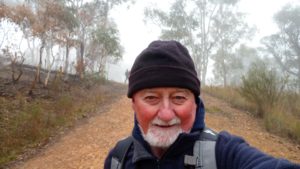
Featured image – Greg on a trail descending from the Little Black Mountain Track
This was a simple training walk from a car park on Frith Rd, near the CSIRO Black Mountain Laboratories, and adjacent to Civic Zone Evo Energy electricity sub-station, up the main summit trail to Black Mountain top. This involved just Drew and I as we are training for an organised walk on some of the Larapinta Trail in Central Australia.
From near the top we took a nice circular trail that goes around the top of Black Mountain named the Forest Loop Trail. It is accessed easily on the north by the Main summits trails and from the south from the main vehicular road access. There are also some footpad accesses on the east side (3) and a couple (2) on the west side.
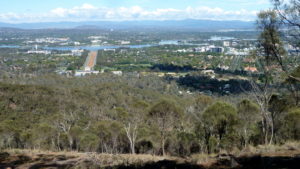
After going right around the top we climbed to the top on the main access trail then came down on another part of the main trail and went straight down to the junction of the Kids Lookout Trail, the Black Mountain Trail and the Little Black Mountain trail. We then took the little Black Mountain trail along and parallel to the ridge to the north which is unofficially known by bushwalkers as the Little Black Mountain ridge or just Little Black Mountain. From the trail we took the first junction right and down to join the Powerline Trail which also is part of the Canberra Centenial trail (CCT) for a short stretch south to the car park where our cars were located. Then it was home for breakfast.
It was a good training walk but somewhat deflating to get passed by younger young men and women and even an older women running up and down the main trails.
It was a tough walk of 5.7Km, taking 1hr 41m.
Map of walk | Pictures in Google Photos | files including gps located in Google Drive
Notes re Map: GPS Map View provided using Garmin Basecamp on an Open Streets Map (OSM) NSW base | The area of the walk is covered by the NSW 1:25,000 topo map CANBERRA
PostTags: Black Mountain, Little Black Mountain, Forest Loop Trail, Civic Zone Electricity Sub-Station, Canberra Centennial Trail (CCT), Larapinta Trail