2020 Dec 17-18 Arsenic Ridge Resurvey from Brooks Hut site to Tabletop Trail
This was a 2 day driving and walking trip to Brooks Hut site near Happy Jacks, then multiple walking sessions finding and re-tapping the best route for a walking track between Brooks Hut site and the Tabletop Trail ending close to Tabletop itself. This was a repeat of a similar trip in Nov 2019 that tapped the same route. However the severe bush fires of Dec 2019 – Jan 2020 burnt the area badly and destroyed most of the previous work. In 2020 it was now easier to pick up any signs of the old bridle trail and road that went over the same route
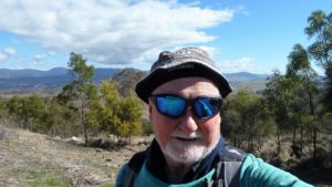
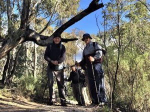
The featured image is a picture of three of the guys at the Cairn site close to Tabletop Trail. The guys are from left to right, Stefan, Robert and Mika
More pictures on Google Photos
17 – 18 Dec 2020 – Arsenic Ridge Resurvey – From Brooks Hut site to Tabletop Trail via Temperance Ck
Synopsis: This information is about the Arsenic Ridge proposed Track which sits between the Tabletop Trail just east of Tabletop Mountain itself and Brooks Hut site down near Happy Jacks Creek. This will offer walkers on the Australian Alps Walking Trail (AAWT) the ability to save 2.7 to 6.9Km of distance as well as revisit part of an old historic route from Victoria to the NSW Kiandra Gold Fields, called Ligar’s Route..
The Arsenic Trail was originally part of Ligars historic route that went from Victoria to the NSW Kiandra Gold Fields. Old parish maps show Ligar’s route being represented by a stock route and trail from Doubtful Gap north alongside Diggers Creek before joining Tibeaudo Ck and then across to junction of McKeahnies Ck and Happy Jack’s Creek and then taking Arsenic Ridge up north before entering Temperance Ck valley and continuing up not far from the Tabletop Hut and then to old tracks running north west around Tabletop Mountain.
WARNING: This not yet an official trail or track as such. You walk it at you own peril. This doesn’t mean it’s dangerous or difficult. Overall it’s a nice easy-medium walk albeit with some scrub and fallen timber along the route. However it is now fully taped but with biodegradable tape, so in a year’s time or so that tape will probably be gone. However the extensive 170+ taped points will allow anyone to walk the route. Note: we used a mixture of pink and orange tape.
The Trip
In late Nov 2019 five walkers were allowed to survey the old Arsenic Ridge track route from the Tabletop Trail near Tabletop down to Brooks Hut and tape the route.
In Jan 2020 a huge fire swept through the area burning much of the area and many historic huts, including Brooks, 4Mile and Happys Hut as well as all huts along the Snowy Mountains Highway.
The team that surveyed and taped the route were allowed to go back and retape the route in Dec 2020.
After much discussion we agreed to go back just before Christmas 2020.

Robert picked me up early morning Thursday 17th Dec 2020 and we drove pretty much straight down to Happy Jacks Rd via Eucumbene Road. Robert had acquired two sets of keys from NPWS and so we had to meet others at the car park along the road so we could all go in together. One member Mika Kontiainen was going to come much later in the day so he was given one set of keys.
At Happy Jacks Road we met Stefan and Klaus Huenke (yes the writer) who Robert had invited.
Driving along the Happy Jacks Rd we came across several other vehicles a couple of which included senior local NPWS Rangers who were known to Robert as well a local farmer Barry Aitchison who owns the property that sits right under Mt Hudson and who had a great knowledge of the early settlers of the area. After a long chat we continued around to Happy Jacks Rd near Brooks Hut and realised Klaus would not get his camper van into Brooks so we left him on Happys Jacks Rd whilst we drove into Brooks on the very rough grassy access track. It was not very easy to notice as the access track was overgrown in places and the recent rains has stimulated significant growth. But we made it OK. The grass around Brooks was very thick and high; I have never seen it that high. It reminded me of Four Mile Hut last month. The Chimney still stand at Brooks as well as some of the metal frame work around the base of the main floor but it was substantially burnt out. It provides no shelter.
There is still a cement low level well some 30m SE of Brooks Hut (103 deg true) and down in a slight gully. There is so much grass around it making it hard to use. However as the grass dies off over winter it should be more accessible
We decided to collect Klaus and then do a survey up the route after lunch. Whilst Stefan went back to Happy Jacks Rd to collect Klaus. Robert and I went up behind Brooks and started to survey some points up the first stage of the ridge. We actually went further than we had planned and eventually reached The Rock lookout or Jargunal View.

We went back down the route we had come as we didn’t wish to go too far, and in the valley west of Brooks we met Stefan and Klaus who had started their own walk by stopping before Brooks and looking for the old route south of Brooks. There does seem to be a lot of old ruts indicating there were many old tracks around.
We returned to Brook’s site for some lunch then went back up behind Brooks and showed them the route up to The Rock. We left Klaus at this spot and he promised to boil the billy for us, whilst the three of us went up the ridgeline, which we found quite easy, although working out the best route was always tricky. Going around the eastern side of SMA 0397, which is a distinct hill was hard to determine the best route. Initially we all took slightly different routes down to the distinct saddle just north of this hill.
We turned around here and went back refining the route in several places.
When we got back to the Rock we were all lucky to get a Klaus smoked brew which was nice. We had some discussion and generally agreed The Rock should be included in any formal track that eventuates, and the route should take walkers there, rather than making it a side track option. We also thought the name “The Rock” lacked pithiness and I think Klaus or Stefan suggested Jargunal (pronounced ‘jar-gun-al) as an alternative name which they thought was another optional suggested pronunciation of Mt Jagungal.
We walked back to Brooks and drove backs to Happy Jacks Rd and ended up camping a little way east and off to the North side of the road. Later Mika turned up and camped with us.
We had a group discussion around a campfire, as you do, and planned the attack for the next day. Klaus also read a few sections from his new book about 4 Mile Hut entitled “The LIFE of a MOUNTAIN HUT”. Refer to Tabletop Press for his books and more. He also read out some poetry from his most recent book.
On the next Day, Fri 18th Dec we drove over to Brooks again leaving Klaus on Happy Jacks Rd. We then went back up the rough route we had already taped showing Mika and refining a few spots until we got to the saddle just north of SMA0397. We had several discussions but eventually went up slightly more to the right than last year and made SMA 0396, which Stefan found, a historic spot to pass – waypoint BT16 Mulligans Hill 1 Trig (SMA396).
We found it interesting that the original surveyors (we read party of two had written into the cement on both sites) had used Mulligans Hill 1 for BT16 the northern trig site but Mulligans Hill 2 for the southern site. Yet the SMA maps and modern topo maps only show SMA0396 and SMA0397. Both the trig sites have SMHEA marked into the concrete so was very early in the life of the Snowy Scheme.
We then continued uphill in a fairly straight line, swinging a little to NE near the ridge top and then heading down over increasing deep grass as we came across the top of Mulligans Creek source.
We did find two stumps that used to be along this route close to the Bolton Hill Fire Trail but the stumps will not be viewable into the future as they were burnt to nearly ground level. The fire trail is heavily overgrown but we could still pick up the alignment of it.
We walked down across more open ground to a tributary creek of Temperance Ck. This tributary always seems to have some flow. We didn’t tape the route much over this ground as it was a bit swampy and soft and we thought we should leave it to a construction crew to refine the best route. However if the track is never formally approved one could still walk it on a straight line as its only 200m and not covered in thick scrub.
Walking along the side of Temperance Valley we were able to pick up much of the old trail route although we took a few deviations around heavily rutted parts especially in the northern section near the main Temperance Ck crossing.
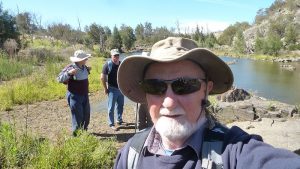
Temperance Ck crossing is a nice spot to rest and get some nice fresh water. It’s a permanent creek fed by several swamps up below the Tabletop Trail.

We went up a ridgeline above the creek but at the top where one of the Temperance Ck swamps is we decided eventually to route the proposed track further west of what we believed was the old route. This was because we could see it had quite a lot of sphagnum moss much of which had been burnt in the Jan 2020 fires.
The reroute took us west and then north around a ridgeline that separated one higher Temperance Ck valley from another one to the west. Just as we were about to head uphill we crossed a well-made water race probably built in the late 1880’s for gold mining. Note this race has been traced from a Temperance Ck swamp around 900m east of this point and travels about 3.5Km North-West to the Main Header Dam along Tabletop Trail and right next to the big hole you can see near the Trail. It’s called the Empress Sluice Gully.
From the race crossing it’s only about 700m up to the Cairn close to the Tabletop Trail. We actually went up a little to the east and realigned the trail as we came back down.
We returned back down our taped route tweaking the alignment as we went. We stopped for a bit of lunch down on the Temperance Ck crossing.
We were back at Brooks fairly early and returned to our camp site along Happy Jacks road. We had planned to spend another night there but several of the guys wanted to camp along Happy Jacks Rd near Mt Hudson and get the great views over Lake Eucumbene. So we packed up and drove around to the Snowy Hydro radio repeater site. However the wind at that spot was quite strong so we decided eventually to head home. I got home around 7.30PM.
In early Jan 2021 Robert Green passed on details of what we achieved in late December, plus maps, gps data and some pictures to NPWS.
Pictures of the Trip – Google Photos of the Trip
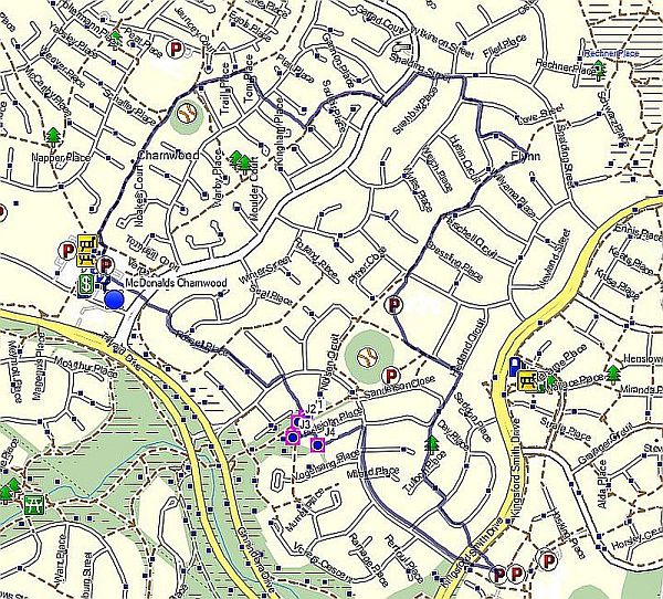
Documents, GPS Files and Trip Maps in Google Drive folders – KNP Dec 2020 Tabletop – Brooks Hut site – Arsenic Ridge
Posts Categories and Tags
Categories: AAWT, Huts, Kosciuszko NP, Mountains, NSW, Walk
Tags: Happys Jacks Road, Brooks Hut site, Arsenic Ridge, The Rock, Jargunal View, SMA0396, SMA0307, Mulligan Hill 1, Mulligan Hill 2, Bolton Hill Fire Trail, Temperance Ck, Tabletop Trail
Greg Hutchison Jan 2021