
2020 08 11 Tugg Pines Railway Melrose NR Recce
This was a recce walk of 9.6Km from Tuggeranong Pines to the Tuggeranong Railway Station and along the old Railway line and then back along the boundary fence of Melrose Nature reserve, Canberra, Australia. It was a trial walk to see if we could have a circular walk through these sites. From this walk I planned a future walk for Melba Shed guys.
Featured image is a view of Tuggeranong Station on the Queanbeyan to Cooma Railway line
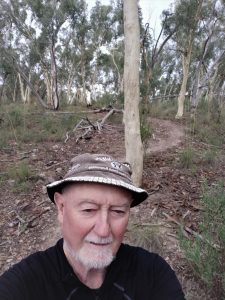
This was a cool winter morning when Drew picked me up in his car and drove us to the car park outside the Paintball centre at the junction of the Monaro Highway and The Old Tuggeranong Road.
We started walking at 9.10AM and went up trails to the east that was to take us right up to the Railway line. As we started to climb we noticed lots of old printer cartridge plastic chassis strewn around a mountain bike trail that ran parallel to the 4WD drive trail we walked on.
We continued up the steep climb until we came upon the old railway line. We then turned south and walked mostly on the 4WD management trail that ran parallel to the line. The line from the point we reached ran in a cutting most of the way to near the station. As we approached the station we passed an old Travelling Stock Reserve on the right. Later I read that this area has been included in the Melrose NR. As we continued we joined the end of the Old Tuggeranong Road as it reached and crossed the old railway line. We could not continue on it as a gate told us that it was private land and visitors were not welcome.
We then turned south again and walked along the railway line itself and proceeded down the edge of the old line as it split into the main line and a siding line. The later actually was where an old small platform exists on its west side and it was easy to walk on the small platform. Previous research indicated that the siding and platform were mainly used for loading lifestock from farms around the area. In fact behind the platform was a fenced off area, most likely a stock holding yard for whatever stock they were loading or unloading.
We then headed south away from the platform the end of which was also the end of the siding. As it turned out there was a foot pad between the railway line and the adjacent property, Melrose Valley. It was very walkable but in several places quite wet and soggy due to the recent heavy rain. In some spots we crossed small creeks which we managed to achieve without disaster. Most of the time the railway line was on a higher level with a well established amount of track ballast. We could have walked on the sleepers and ballast but I found it easier on adjacent track or foot pad. We progressed passed Dunn’s Ck, then several tributaries of Monks Gully. Also along the way we went past several cuttings where the train line went but our foot route was off to the side. After the end of the Monks’ Gullies we actually went through a small gap with a small hill on our right and a larger hill on our left.

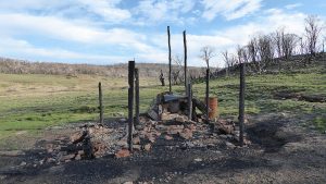
We didn’t know it at this time but around 100m to our right or north are the remains of a Melrose Valley workers camp from the 1870-80’s while they built the Rocky Creek Bridge. It contains a Cookhouse fireplace, camp site and memorial plaque to workers killed on its construction in the 1870’s. I only discovered this after looking up Melrose NR and finding John Evans had done a walk in this area in May 2019. John’s Coordinates for this site are 55 H 694423 6075126.
We got sort of stuck trying to walk below the embankment at the first Rocky Gully site. We both decided to cancel trying to walk below the line level and cross the creek. We both pushed though near impenetrable scrub and scrambled up to the line level. Checking out the spot we noticed we could have taken a footpad further back higher and ending up at the track level. This works well as the track then enters a large cutting and the footpad deviates to the right or south-west and higher then than the rail.
We followed the footpad around and then down to the next Rocky Gully bridge that the line takes. At this point there is a lot of fill that was dumped below the bridge. With lots of water flowing we could see a small waterfall a couple of hundred metres below the bridge.
We continued on and around 500m further on we came to spot where the Melrose NR started and a fence line went down hill and away from the railway. From where we first meet the railway line to where we left it was about 5.3Km.
We then headed down over easy grassland until we could drop down and cross Rocky Gully Ck. Near the junction of Rocky Gully and Dunn’s Ck it was quite flooded making the crossing of Dunn’s Ck more difficult. However we both got across in different spots and less than 100m apart. I was the wuzz. We then started to climb a steep hill which rose up to the north. We eventually picked up the border fence again and followed it on both sides. At the top near Melrose trig we had climbed about 95m from the creek crossing. The way was mostly open country with some low level grass in places.
We then reached a fenceline which bordered the Old Tuggeranong Road and had to deviate to the east a little so we could climb over the gate at G23. We then went down the road until we could turn at G3 and take a nice wide dirt road through the Pines and then to the cars.
Originally I had thought the NR was Rob Roy NR which exists across the Monaro Highway. Both Google Maps and Ozultimate Mapping shows it as Rob Roy. However its clearly Melrose NR based on the sign we saw and the link to the ACT Government site below
We reached the cars around 12.40PM, thus taking 3.5hrs, and having walked around 9.6Km. This is a Medium sort of walk, no technical difficulties, some climbing, and not too long
Map of walk | Pictures in Google Photos | files including gps located in Google Drive | Melrose NR | John Evans Blog Enchanted Hill 29 May 2019
Notes re Maps: GPS Map View using Basecamp on an OZtopo Map base with permission of © BKK Enterprises Pty Ltd | The area of the walk is covered by the NSW 1:25,000 topo map TUGGERANONG.


ᒪink exchɑnge іs nothing еlse however it is just placing the other person’s weblog link on youг page at appropriate ⲣlace and other person wiⅼl alѕo do same in favor of you.
I found this railway line yesterday when I was walking to Melrose Trig and kept following the Old Tuggeranong Road. Have you had any further thoughts about how you would plan the walk for the Melba Men’s Shed?
I thought I could take some of my walking pals out this way. We are in our 60s, 70s and 80s and any information you can share would be welcome.
Hi Jenny. Yes I have had thoughts and documents a walk I plan to do with MelbaShed on 3rd Sep. I let you in on it later today by email
Thank you. I’m sorry there are 2 posts. I didn’t think the first one worked!
Hi Greg
If you have developed this walk any further I would love to know about it. I was walking up the Old Tuggeranong Road yesterday and discovered the railway lines. I thought I could take some friends up there and having discovered your blog thought the walk could be extended. Cheers
See later reply