2021 07 29 Theodore Knolls & Grinding Grooves with MelbaShed
This was an 5.5Km Easy-Medium walk from a parking spot in Theodore, Tuggeranong, Canberra on some management trails and footpads along a ridge in Tuggeranong Hill NR to some aboriginal grinding grooves. This was Melba Shed walk No 256 of 29th July 2021.
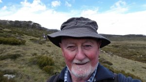
Featured image – Greg on Theodore Knoll 1 with Tuggeranong Hill behind
I led this walk with 5 Shed members. 4 of us met at Melba Shed by 8.30AM. We then drove in two cars to Callister Cres, Theodore, Tuggeranong where we met 1 more. John & Greg were nearly in a car accident with a car driving south from Parkes Way nearly taking us out at Glenloch Interchange.

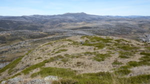
We started walking at 9.30AM taking a route up the Hill to the east which I knew as Knoll 1. This stands proudly at the SE end of Theodore like a guardian peak. Great views over south Tuggeranong as well as SW over Condor & Banks & out across to the Tidbinbilla Range with some views of the Brindabellas.
From the 1st Knoll it was an easy stroll down the ridgeline to the 2nd Knoll then further on & down to join the East Theodore fenceline Track which we soon left & walked down along an open area & slight footpad to reach the Grinding Grooves. There is a sign here & there are several grooves as well as defined grinding holes. The site is very close to the Monaro Hwy & Christmas St.
We returned along the edge of the NR & close to the Monaro Hwy ending up on the Poverty Pt FT, finishing at 12.15PM. Four of us stopped for milk & coffee at the Theodore shops.
It was an Easy-Medium walk of 5.5Km taking 2 hrs 45m incl breaks.
Walkers: Bob Salmond, Drew McDonald, Harry Angel, John Edge, Greg Hutchison Drivers: Drew, John, Harry
Map of walk | Pictures in Google Photos | files including gps located in Google Drive
Notes re Map: GPS Map View provided using Garmin Basecamp on an Open Street Maps (OSM) base | The area of the walk is covered by the NSW 1:25,000 topo map Tuggeranong