2020 05 28 Palmerville Percival Hill Gold Ck Walk with MelbShed
This was an 8.8Km walk from Palmerville, a historical site in North Belconnen, Canberra up past a CSIRO research farm to Percival Hill then to Gold Creek the site of some of the original Ginninderra Village and then back along part of the Canberra Centennial Trail (CCT) to Palmerville. This was Melba Shed walk No 230 on 28th May 2020.
Featured image – Greg in front of Golf Course Pond with Housing Estate behind with gold Creek behind it
Drew led this walk with 9 walking. 5 met at Melba Shed by 8.30AM & drove in two cars to Palmerville, Evatt, where we met 4 more.

Then from 8.50AM in heavy fog, we walked through Palmerville looking at the Memorial Forest & some of the Palmerville historic signs & sites.
After walking down the road of elms to Ginninderra Ck, we turned north & walked along the fenceline to the CSIRO area until we reached a ditch next to the Barton Highway.
We then walked east down the ditch before we could walk under the Barton Highway Roundabout, & then turn to climb up Percival Hill. We initially had to walk across an Icon Water access road to a works site associated with a sewerage vent outlet higher up the hill. We crossed & were able to get through a barbed wire fence & climbed up passing lots of kangaroos & some wallabies to reach the top of Percival Hill (662m).
Unfortunately a heavy fog covered the area & prevented any views. So we headed north then west down to the edge of the Nature reserve next to Nicholls & tracked south until we found what we knew as a child’s grave site which was surrounded by a number of large bolts. We then went west a little to the edge of a pond & around the pond until we could continue west to Gold Creek.
Here we stopped at the old Ginninderra Village area & had morning tea at Armadillos Cafe.
We then returned down past the Dinosuar Museum, the historic homestead of Deasland, then past an old Blacksmith Workshop & along the CCT trail along the Barton Hwy. Then we took a bridge over Ginninderra Ck, then dropped down & under the large roundabout again & then took the bitumen path down Gundaroo Road until we could turn again under Gundaroo Rd, then recross Ginninderra Ck, then drop down again and take another underpass under Gundaroo Rd before we could enter Palmerville, returning to our parked cars about 11.55AM.

The weather had started out foggy but by the time we came down from Percival Hill it became fine and sunny and another perfect day for walking.
Easy-Medium walk, of 8.8km, taking around 3hrs 5mins.
Walkers: Bob Salmond, David Ruthven, Drew McDonald, Harry Angel, Harry Redfern, Peter Coppin, Steve Mawer, Tony Weir, Greg Hutchison
Drivers: Bob Salmond, David Ruthven, Drew McDonald, Harry Angel, Peter Coppin, Steve Mawer
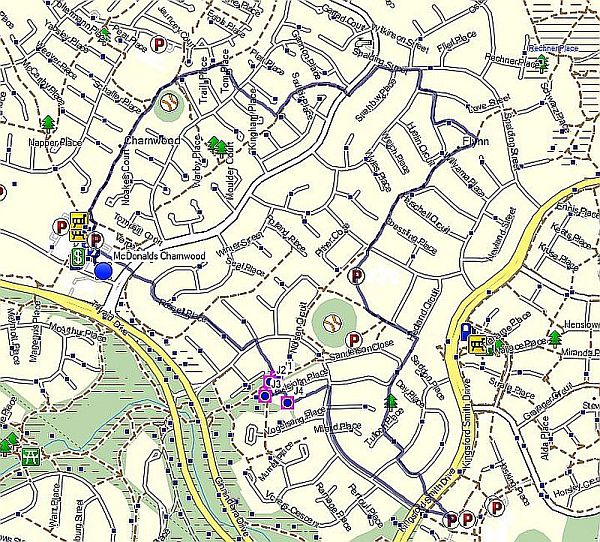
Map of walk | More pictures in Google Photos | files including gps located in Google Drive
Notes re Map: GPS map views on map base using open source Open Street Maps (OSM) NSW Garmin map using Garmin Basecamp | The area of the walk is covered by the NSW 1:25,000 topo map HALL although with all the changes Open Street Maps is a better source of information