2019 10 31 Black Mountain & Little BLMT from Aranda with MelbaShed
This was an 8.7Km walk taking 3hrs 31mins for a circular walk from Aranda, Canberra, Australia along various trails and foot pads to Black Mountain Nature Reserve, over Little Black Mountain and then up Black Mountain itself. This was Melba Shed walk No 216 on 21th Oct 2019.
Featured image is of Lake Burley Griffin & areas to the south from Black Mountain
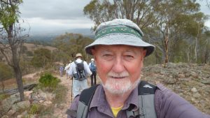
I led this walk with 3 walking. 2 met at the Shed by 8.00AM & then drove via Jamison to Noala Place in Aranda where we parked and we met one more.
Then from 8.34AM we walked across the large bridge over Caswell Dr (ie GDE), turning left so we could enter BLMT Reserve at gate 4 (G4) on map.
Then we did a circular walk, first walking along ridge that is known as Little Black Mountain, then dropping down to the Powerline track to then walk up road behind ANBG then a stiff climb up a track past the Quarry to the top of Black Mountain (BLMT). Walking up Frith Rd extension behind the Australian National Botanical Gardens Harry nearly trode on a small brown snake who was exiting a small gully beside the road. We have to be careful wherever we walk.
From the top we walked down a little known track on the SW side that affords magical views over the National Aboretum and western end of Lake Burley Griffin (LBG) down to Woden. Then we deviated from the plan as it was getting hot and we felt it. So we turned east along the western section of the Forest Trail before dropping down to pick up a nice rail that took us back to Caswell Drive & the GDE before crossing over the GDE again to return to the cars by 12.15PM
Some of the tracks used were more like thin footpads with rocky & slippery surfaces. The temperature for the day was to peak at 32degC so we drank our fair fill of water.
This was an Medium-Hard walk of distance 8.7km taking 3hrs 31mins.
Walkers: Bob Mann, Harry Angel, Greg Hutchison | Drivers: All
Map of walk | More pictures in Google Photos | files including gps located in Google Drive
Notes re Maps: GPS map views provided using Garmin Mapsource with map base from OSM an open source service | The area of the walk is covered by the NSW 1:25,000 topo map CANBERRA. The area has a large number of foot tracks not shown on official maps.