2019 01 22 Mt Ainslie
Nice walk up and around Mt Ainslie in Canberra Australia to help David get fit for a future large walk as well as to revisit some of the trails.
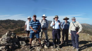
Featured image is the author, Greg at the Mt Ainslie main Lookout
Mt Ainslie stands out in Canberra as one of the large hills that surrounds the centre of the City as well as having a drivable bitumen road to the top with a nice free lookout providing unhinded views down over the War Memorial, Anzac Parade, the Old parliament House and the current new Parliament House. It also has great views over Lake Burley Griffin, Canberra airport, views south to Woden and west to the Brindabella Ranges. Walking the northern fringes of Mt Ainslie you can also get views west to Belconnen and north west to Gungahlin.
It has numerous tracks that climb from its base to its top, thus making it suitable for cyclers, runners and walkers to try and get fit as well as enjoy some great views.
On this occasion David R from Melba Shed wished to continue his training efforts by climbing up one of its trails in preparation for walking the Laparinta Trail near Alice Springs. As the forecast for the day was a max of 37 degC we decided to meet early at 7AM and drive to a spot at Hackett where we could park and quickly start our walk.
So at just on 7.30AM we started walking heading up a main trail SE to the top of a ridge and then a powerline trail south before we turned right following the route of the Canberra Centennial Trail (CCT) until we climbed to a location where five different trails and footpads met. I nick-named it the Five Ways years ago. We then continued on the CCT trail which follows an old footpad just below the main car ascent road.

After a short trip along the footpad we turned up some steps to reach the main road following along its edge to reach the main Mt Ainslie Lookout with its amazing majestic views over central Canberra. From here we took the Anzac memorial walk down a bitumen footpath that continues down to near the War memorial. It is very popular path for tourists and public servants out for a run trying to get the pressures of the bureaucracy out of their system. We didn’t go all the way taking a dirt shortcut to another point on the track down, but turning right instead and dropping down an old access footpad which took us down to a formal management trail around the western side of Mt Ainslie. However we did get lost going down and went instead down and across some open bushland which was easy going.
We followed the trail north for around 1Km before turning north on another footpad that took us around until we could head north over a small ridge past the 5 Senses Labyrinth location and then picking up another main trail down. At another junction with the Western Powerline Trail we turned NE and went along an old footpad before reaching the car at around 9.32AM
We started at 7.30AM and finished at 9.32AM, having thus walked 7.0Km in 2 hr 2 mins have climbed from 620m at the car up to 830m at the top of the mountain.
Map of walk | Pictures in Google Photos | gps, gpx, GE & jpg map files are all located in Google Drive
Note: The GPS map view was created using OZtopo Map with permission of © BKK Enterprises Pty Ltd, http://www.gpsoz.com.au