Kosciuszko National Park – 22-26 Apr 2023 – Gungarlin – Kidmans Hut – Mawsons – Geehi Valley – Alt Rte Back to Kidmans Trip Report
This was 5 days and 50 Km medium-hard walk from the Gungarlin River Camp Ground to Kidmans Hut, then up through the Burrungubugge River gorge to the Great Dividing Range to Mawsons Hut, thence north to Bluff Tarn, Geehi River, returning via Bulls Peak Range down to Dominic’s Camp area, thence a neat track down to the normal route back
The featured image is a view of a Bluff Tarn, a magic spot with little fish
My pictures of this trip are available on Google Photos.
Introduction
This was a 5 days and nearly 50 Km medium-hard walk from the Snowy Plains at the Gungarlin Campground to Kidmans Hut, then up through the Burrungubugge River gorge to near the Great Dividing Range to Mawsons Hut, followed by visiting Bluff Tarn, then the Geehi River Valley, ending with a leg to Bulls Peak Ridge, down a route to Dominics Campsite ending with a nice unknown track to join the route back to the Gungarlin River Campsite.
On the morning of the 22nd Apr 2023, I set off from Canberra and headed to the Gungarlin River to walk across the large plain in front of Davey’s hut, and then Teddys Ck area of Snowy Plains to Kidman’s Hut, thence up an old bridle trail route to the Great Divide just north of Big Brassy, and down to Mawson’s Hut. Then it was to Bluff Tarn and down to the Geehi Valley searching for signs of any bridle trail across to the Strumbo area. I then, ended with a leg to Bulls Peak Ridge, down a route to Dominic’s Campsite and finally ended with a nice unknown track south to join the route back to the Gungarlin River Campsite.
Note: Waypoint/Points mentioned in this document refer to waypoints in the GPX file as well as shown on the trip maps. The waypoint naming and numbering was relabelled a year ago to make it consistent and include many cairns along the way. I have to include some more new points after using an old route from North Gungarlin.
Warning & Dangers
The area mentioned in this writeup is largely rugged and partly untamed. Yes, it was grazed in the Stockmans’ Days and many walkers have negotiated the area since. There is substantial bush to be negotiated and some large trees to be wary off. The area was heavily burnt in the 2003 fires and has recovered with a vengeance i.e. the scrub in 2022/3 is sometimes denser than what was there in 2002. The climb from the Gungahlin Valley at the junction of Teddy’s Ck and Collins Ck is not difficult but the track negotiates an area bordered with extremely large and tall gum trees, probably alpine ash, all of which were heavily burnt in 2003 and many large trees have fallen, some across the track, although now cleared since the trail was bulldozed in early 2023 to Little Brassy Gap. There is no formal track past the Little Brassy Gap (also shown as Brassy gap on some maps) which is the location where you would pass through the Little Brassy Range and then head down to Kidmans Hut. This gap is often covered in snow in winter up to October. Mobile phone coverage is limited with Little Brassy Gap and parts of the Great Divide (Including up behind Tin hut & maybe the Mailbox) being the only spots where coverage is guaranteed. The altitudes are also high for Australian walks with the Gungarlin Valley, around 1,300-1,400m (and can be snow covered in winter), 1,635m at Little Brassy Gap, 1,515m Kidmans Hut, 1,855m crossing through the gap north of the Brassy Mountains, 1,810m at Mawson’s Hut, 1,860m at Tin Hut, Gungartan Pass 2,000m, Mt Jagungal 2061m, The Mailbox 1,920m, Nimmo Hill 1,480m.
Day 1 – Sat 22nd Apr
I left Canberra around 6.45AM and drove to Cooma where I had coffee and some breakfast at Maccas. I then drove via Rocky Plains down to the Nimmo Bridge crossing of the Eucumbene River, then up to Nimmo Hill and then down to the Gungarlin River Camp Ground. The whole dirt road from Eucumbene Road to Nimmo Hill and the Gungarlin River Camp ground was rough and had been badly impacted by the last year’s heavy rains. It’s probably best for non-SUV type vehicles, i.e., the normal 2W drive sedan, to not drive down this road.
Gungarlin River Camp Ground GPS reading 638877 5987737, altitude 1320m approx. I think you still have to book to camp here, but leaving cars to do a bushwalk is fine.
I then started the walk quite late around 10.50AM, crossing the wooden bridge then walking up the fire trail for a short distance until I could turn right, pass under the power line then follow a 4WD trail across the plain, having to cross the small Diggers Ck before reaching the muddy crossing of Campbells Ck. I actually went upstream 50m or so to enable me to hop across the creek. On the way across the plain I could see Daveys Hut off to the west or left side. Davey’s Hut from past visits GPS 637851 5989446
After Campbells Ck there is shortly another junction where Teddys Ck Trail comes in from the right ie east but I went straight ahead up a short sharp climb. The maps show that Teddys Ck comes from private property to the north and then continues in my direction to the end of the Valley along a narrow route that also carries Teddy’s Creek. The trail along this route, although called on the maps Teddys CK Fire Trail is also known by the locals as The Broken Dray Trail. It actually continues up to the right and goes through to private land known as The Barley Fields.
Near where the trail climbed away from the open valley there are the remains of a famous Hut site Napthalis Homestead Site GPS 638146 5990522. The site has a NPWS plaque with some history on the site. They also name it as Snowy Plains House. It was built in 1900s by Jardine for logging and grazing. Collapsed in the 1940s.
Walking along Teddys Ck Trail I had to hop across Teddys Ck once. Later at the Collins Ck Junction joining Teddys Ck FT I didn’t need to hop across as the creek was low but wide. I simply walked across getting wet boots on the outside only. Sneaker wearers would have got wet sneakers inside. I stopped for a quick lunch here.
Walking up to Mill Flat I noticed that the old track had recently been bulldozed making it wider in some sections and clearer down to dirt in many places. At the top end of Mill Flat they had installed those recycled drain pipes making the crossing of the unnamed creek now very easy.
I found the going easy but a bit demanding on my old body so I did stop a couple of times to rest. I reached Little Brassy Gap OK but had to trundle over the old muddy stretches now harder as they had bulldozed away all the branches and rocks people had placed there to cross the mud and water.
Little Brassy Gap was the highest point on Day 1 being around 1,635m. Mobile Phone calls (Telstra & Optus at least) can be made from here. From this spot one usually gets a splendid view of the Brassy Mountains to the south-west as well as the ridge to its north to The Mailbox. The whole upper Burrungubugge River valley was also in view, although you can’t see Kidman’s hut from this spot.
I then continued down the obvious track that heads down roughly south west initially over an open wet plain until it forces the walker to exit the plain through an old cutting to then cross an awkward bushy creek (it was once bridged as was the crossing of Teddys Ck) before continuing down the valley on its northern side. A range of cairns and the odd tag guided me most of the way. I then had to cross a very muddy creek and climb up onto dry land before heading down through a vague track until a more definitive track could be followed down to then carefully cross another creek before the final leg to Kidmans.
This final section is mostly open although badly disturbed by wild pigs. They have created a fair track down towards a major tributary of the Burrungubugge River which I crossed carefully. I then tracked a bit to the south to avoid scrub and then turned north to reach Kidmans by 4.54PM.
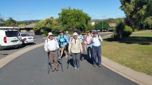
I was surprised to see 3 people already there who had their tents up and the fire going inside the hut. They also took the best tent spots.
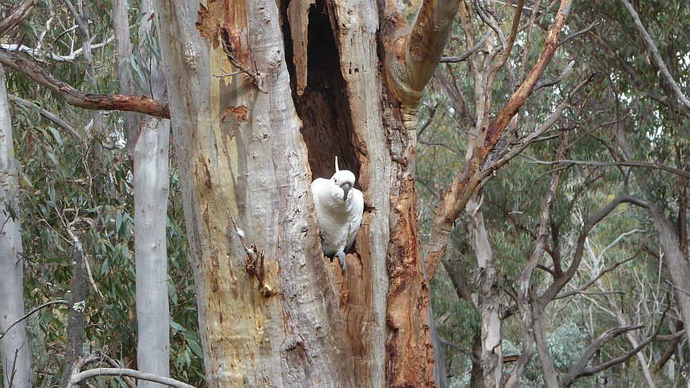
They were all from Canberra: Nathan, Thomas and Hannah. Hannah was the partner of one of them. I forget which one it was. The guys were plumbers and worked for Watertight Canberra. Hannah had got some photos of wildlife. One was of a Copperhead snake, no surprises there although, I had seen none. However, the next one was a shock. It was a Tiger snake with thick dark bands near its head. The one I had seen several years ago was a common eastern Tiger with silvery yellow bands. It was somewhere along Teddys Ck trail. Unless she was having a piece of me!
I then setup my tent and collected some water. They invited me to cook inside and share their fire which I did. However, I was way behind them and finished dinner quite late. They had parked at the Gungarlin Camp Ground as I did but somehow they ended up walking up Collins Ck rather than the old track. They turned right eventually and ended up on the new track. They still beat me to the hut. I must have had too many breaks.
On Day 1, I did 12.4Km to Kidmans, and of course I had driven around 200Km as well.
Kidman’s Hut GPS 631845 5991223, altitude 1515m. It’s a corrugated iron original stockmen’s hut built about 1932 by Ken and Alec Kidman & Bill Napthali. It’s a single room, 3.6 x 3m unlined, fireplace, with a stone floor. The corrugated galvanised iron was fixed to nogged timber frame. It has a wooden board door, with no window. The fireplace with timber frame, galvanised iron cladding and rock lining. The fireplace was rebuilt by NPWS tradesmen in 2007. According to Robert Green the floor was covered in stones after the fireplace was rebuilt by Ian Frakes and hut maintainer Ian Macaulay around 2008. (Data mostly from David Scott)
Day 2 – Sun 23rd Apr
I arose late around 6.30AM to a cold morning. It took a while to pack up and breakfast. The others also arose and left for the Gungarlin just before I left about 9.00AM.
I followed the old historic bridle trail route up from Kidmans, although the first section is a steep climb up a small recut section until I reached the small plain above. I then passed a large cairn on a rock, now labelled K052 Cairn, crossed a small low scrubby section before I could see another small cut section now labelled K053 Rte Up. This spot, marked where I could follow a footpad up to a higher open area next to a Cairn now labelled Cairn 2.
I deviated around 70m to the north from Cairn 2 to see if I could easily head up along the edge of the Burrungubugge Ck trib, but I soon struck quite thick scrub, so I turned back and followed the usual route to the Burrungubugge Gorge.
From there I went south west down to a marker WP K058 M01 (M for Mika) which then allowed me to get easily to another Cairn now K060 Cairn. I then headed across the valley with a creek to cross now WP K062 Ck before heading slightly uphill past point WP K063 then point K064. Along this last section there was a lot of thick woody low-level scrub which had to be walked around before I reached the point now WP K065 Bottom Burrung Gorge. I was now in the real Burrungubugge Gorge which I knew fairly well and would take me up to the McDonald diggings and a large open plain above its top.
I initially went to point WP now K066.
I had previously relabelled all waypoints in the form Knnn starting from the Gungarlin River as K001 and reaching K045 on the creek just before Kidmans and I then restarted points at K050 just above Kidmans. Some waypoints have these designations plus a Cairn number mostly of the form Knnn Cnn if a Cairn was involved.
From here I was able to follow all the points up to the top of Burrungubugge Gorge at WP K088 C26 Top. I then traversed across the tops which is easy but very uneven and slightly scrubby to the north-west side of the river. The stone piles seen on the south side are the McDonald Diggings GPS 630416 5991396.
The river was flowing slightly stronger than usual and was a slightly deeper than usual which was to be expected. However, I was able to cross without getting the insides of my boots better by crossing around point labelled Diggings Rock Pile (Sth Side).
I then went up across a large open field using a feint footpad towards the next ridgeline that had to be climbed. I reached point WP K092 Jn for Alpine where in the past I had turned to traverse the small valley in that direction before it goes over a crest and heads towards the old lost Alpine Hut site.
I then headed up a lightly scrub covered ridge to reach an area that stockmen used to camp and rest their stock before taking the final climb up to the Great Dividing Range.
I then headed south to pick up point WP K097 C32 Tk Bottom on a rock that represents the spot where the old Bridle Trail turned slightly south to then go up a ridge to the next level of the river valley, a large open bowl below the Mailbox and its southern ridge that is the start of the Burrungubugge River.
Near this Cairn there is an old historic Cattleman’s fireplace GPS 629902 5991094 but is largely covered with scrub so I did not check it out.
I then headed up the first section for around 100m south proving easy and finding some tags. There is a steep pitch uphill from K100 through to K101 up to a crest at K102 which is the top before reaching a small open spot which is a good location to rest and check where one is at, its WP K102 Rest Spot. This section up to this spot is probably the steepest on this route. I stopped at this point which is a rock in the middle of a small clearing and had lunch.
I then headed up the route I knew. However, I had to check my old track and waypoints continually. I made it to point K126 near where I had to trim back bits of a fallen branch that had fallen awkwardly across the track. Just above it was the last section of track of around 5 metres or so of real track, which is usually covered in permanent snow until Nov. I cut back a few metres of overhanging scrub making it easier to walk through. I then went uphill a little to point K129 Big cairn. Someone has placed a large rock on top of a low rock creating a cairn like feature. It’s a spot where you get a good view back over the valleys and hills. It’s also the first point where you get mobile coverage since Little Brassy Gap. I rang the wife.
I made WP K130 Tk Top (Big Rock), which is only 50m from the Burrungubugge River branch which is where there is easy access to clean permanent flowing water. Here I rested and filled up with water. It was getting on ie.3.15PM which was a little late. I still had to get onto the great Divide.
I then followed an old route through mostly clear ground from points M01 to M18. It went south from where I rested then swung west and then up mostly open ground with some trees and fallen timber to get around. This took me onto a higher plain like bowl which I went around the edge of before climbing another scrubby hillside to reach the Great Divide. I rested on the top and have no doubt mobile calls could be made here. Near Point M12 I believe is an effective gap in the Great Divide between the Brassy Range and the Plateau leading north to the Mailbox, i.e., the real Brassy Gap!
I then followed across the plateau turning NW then fully West to reach the western side of the plateau where there are a couple of cairns M20 and M22 pointing the way to the west or really SW until I could pass another Cairn M23 which is small Cap Like Rock. From here it was an easy stroll downhill for around 150-200m after which it gets covered with low level scrub. From around M27 to M33 it was covered with various amounts of scrub and some unlevel ground. After that there was some nice open grassy ground with the final leg down to the river then being on open ground with some small scrub in places.
I reached the Valentine River crossing point at 5.40PM as it was getting dark. Yikes! I had done this, two years previously, and vowed never to do such a thing again. This time it was slightly earlier. I then took off my gaiters and boots, put on my crocs and waded across to the other side and sat down on the far bank just around the southern tip of the island. By the time I was putting my footwear back on it was darker and hard to put on my gaiters. My headtorch was way down in my pack. Bugger! I got it done then went up the slope and using my GPS headed 330m for Mawson’s Hut. I was walking in the dark but the GPS kept me on target. I made the hut around 6.27PM. I was cold and tired and hoped someone was there and had made a nice fire.

Wasn’t to be. However, two people were there and had put up two tents. They got a shock when I went to the door. They were nice and let me use their headtorch until I could put up my tent etc. They also let me use their water to save me going down to the creek in the dark. But they hadn’t started the stove in the hut which would have been nice. It was now cold.
All was well I got the tent up and was able to cook on my stove in the hut like the previous night.
Today I did only 8.6km. Gosh! It felt like a lot more!
The two people were from Sydney. They were Mark an older guy and Lucia a younger woman. I learnt that Lucia’s partner was overseas climbing in Alaska. They were going back around towards Valentine Hut to pick up the Valentine Trail and head for Horse Gully Hut that day. They were nice people.
Day 3 – Mon 24th Apr
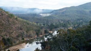
I got up fairly early around 6AM but after breaking camp, packing properly and filling out the log book I didn’t get away until around 9.15AM slightly after the other two. I had an easy trip north. However, after passing where the old stock yards were north of the Hut. I deviated slightly to the north east to walk over easy ground to get to a spot where I could cross the Valentine River and cross without taking off my boots. It was fairly soft going near the river but I did manage to cross without taking off my boots. The east side was slightly harder going with a lot of soft ground cover making for slow going. I passed Big Bend with it being 150m to my left side and then I continued along the east side of the valley. I gradually climbed until I reached the first side valley on right side. I knew this would take me to Bluff Tarn. I crossed the valley and went up its north side heading easterly. As I reached the top I turned left and went down the left-hand side of the new valley around 200m before I realised, I should have turned right to go over a crest some 300m to the east. So, I crossed the small valley and then headed uphill to the east. It was the usual soft underfoot swampy type of ground which is hard work walking over. Any way I made the top OK and was then on an open ground partially broken with little creek flows over a large flat area with the Cup and Saucer on my right and Tarn Bluff way to my left. I headed straight across this area and reached the top of the gap that would take me down to Bluff Tarn, 55 H 626998 5992777. There were some nice views of the Tarn from where I was. However, I headed down its left or northern side OK and then stopped to have lunch on a large rock next to the Tarn.
It’s a great spot for lunch with a fabulous view across to the Mailbox. The Tarn is populated with very small fish maybe up to a max 60-70 mm in length. Could they be Kosciuszko Galaxias, Galaxias supremus Raadik 2014 Max size 10cm. (These only occur in the headwaters of Carruthers Creek and Blue Lake in the upper reaches of Blue Creek system, upper Snowy River on Mount Kosciuszko, Mount Kosciuszko National Park, at an elevation of 1,900 to 1,950 m) There is also this one, The Stocky Galaxias a newly described small fish which grows to a maximum of 103mm long. It is only known to occur in the headwaters of Tantangara Creek, upstream of the Tantangara Reservoir in NSW.
After lunch I walked north east from the Tarn along the eastern side of the valley heading for the ridgeline that went north from below the Mailbox and down to the Geehi River. The creek flowing from the Tarn does head north and eventually join the Geehi River.
I climbed up the side of the ridgeline which was hard going with numerous trees and scrub. I reached the ridgeline north of where I needed to be, so I turned south and headed towards The Mailbox. The area was more densely covered than when I was here 10 years ago. Could not initially see any embankments but when I turned east to drop down into a creek that flows right down to the Geehi Valley I found myself on some dead grass that had grown in a trough or race that looks similar to the long embankment. However, it was slightly off the main part of the ridgeline being off to the east side. I plotted my old embankment line and the main one seemed further east than the new waypoint I took. At the point I was it seemed to be 20m different although its likely my old reading was not as accurate as it could have been. I am no longer confident that it was an embankment but am very unsure of the purpose of whatever it was.
I walked down to the creek line and followed it down all the way to the Geehi Trib Ck. I could not clearly see any likely track that would have cut across the creek and up and over the ridgeline that the embankment was on.
I then turned west and followed the creek valley downstream. The valley was quite wide and it was slow moving over easy ground but some sections of swampy ground. At one point I spotted a possible small cutting coming up from the valley but I am still not convinced about it.
I stopped about 4.20PM and looked for a camp site next to some small rocks. It was hard to choose a site as all the grass was bumpy and flat sites were at a premium.

My campsite had a great view back up a Geehi Trib which went up to the bare area north of the Bulls Peak. Might have been an old track down from there on David’s Maps. I could also see Jagungal way to the north. My view downstream was impeded a little by the end of the Embankment ridgeline extending right down into the valley. I was around 3 km at least away from where I planned to be originally.
Day 4 – Tue 25th Apr
It was a frosty cold morning but another dry sunny day I could see. I had my usual slow breakfast and pack up.
I didn’t get going until 10AM. Pretty slack mate! OK but I was still tired.

I went back along the valley a little then crossed the creek including the creek coming down from Bulls Pk North way, and then climbed up to an outstanding rock formation across the valley. It was not so high especially on its uphill side.
It gave me superb views downstream, to Jagungal and the hills behind where I camped.
Very Large Rock Outcrop (good views Geehi R, Jagungal) 55 H 628366 5994124.
From this vantage point I could see some thin strips of vegetation going across the end of the ridgeline, from the edge of the Mailbox lower vegetation right around and past the area where I camped. I got the impression these lines might be the remnants of an old rough track with the rut holding more moisture and permitting some vegetation to survive on a fairly barren surface. I wasn’t in a position to take time to go back over to the area as I had to get up to Bulls Peak Ridge and find a way down to Dominic’s Camp if at all possible.
I left the Outcrop and headed SE initially recrossing the Geehi Trib Ck. I then reached a nice grassy dry spot with some trees that might provide firewood and with the creek downhill around 40m. Quite a nice camp site overall. I then continued up the SW side of the valley not seeing any signs of old tracks but after a couple of hundred metres I turned left to try and cross the valley to get onto the left side which would bring me onto the Bulls Peak Ridgeline. This I achieved OK but stopped in the middle of the valley to collect water. There was a series of strongly flowing creek water with mini waterfalls so overall a good water spot. I then continued upstream in a SE direction and eventually reaching the edge of the Bulls Peak Ridgeline. In the process I noticed that there had been a large area of vegetation cleared and/or burnt. This created a large open circular area plus strips of cleared vegetation heading south to at least the crest. This was created by a small ridgeline going east west to the south. It doesn’t seem to be shown on topo maps. The old Bulls Peak track came over this crest then near the bottom moved slightly east to line up with the Bulls Peak Ridge. I guess you could derive that the Bulls Peak Ridge started around this crest mentioned above.
I walked onto the ridge and then went to the eastern side to try and take an old track that went down into the small valley to the east of the ridgeline. I thought it would be any easy route down. However, the old piece of track is well and truly overgrown and no more. So, I walked in that direction, which on reflection was a mistake as even way back in 2012 I had taken a route down slightly closer to Bulls Peak South.
I carefully walked along the side of the ridgeline until I could find a nice spot and had lunch. I then went further south and found the old NPWS sign 608, which is still there. Interestingly, from this spot which is also on a crest looking south you can see the swampy valleys that form the source of the Burrungubugge River. There is one small stream downhill from the Cutting on The Mailbox that flows down into this valley thus proving that the Burrungubugge does in fact rise on The Mailbox.
From the NPWS sign I then went back down the eastern side of the valley which started OK but as I went north it deteriorated into large rocky areas and thicker scrub which became dangerous so I dropped down as fast as possible whilst trying to reach Stephen Joske’s waypoint “Crossing Ck SJ’. It was a bit steep and awkward. The only issue I had was did he mean cross like I did or cross the other way. Anyway, it was too late, I then had a scrub bash along the edge of the ck until I could slide down a long hill and recross the ck further along, which I did (It’s not marked on trip maps as it was easy). I then headed SE and then easterly to reach SJ2 point and I made my own point which I labelled GH2. I had noticed that I missed SJ1 which later became obvious that I had gone too far east after the creek crossing. I then headed uphill slightly intending to try and reach SJ3. I then made a mistake by going too far uphill as I found the going easier, meaning I was 60m uphill from SJ3. I kept going my way and then I was on the edge of a large flat field. Nice but my GH4 point was higher and 150m away from SJ4. OK not good but my route was looking nice so I headed along the edge of the open field in a SE direction, same as SJ effectively. Thus, my GH5 point ended up 100m south of SJ4.
I knew I had to synchronise my route with SJ eventually so I now turned more left to try and meet SJ’s route as I could see there was an important turn coming up. However, I missed his “SJ Open Ridge Right” waypoint but after around 250m going down gradually over treed open grassland I stopped for a break at GH6 being now just 20m north of SJ6. It was an open small area with a couple of open lanes heading further downhill. I continued down an obvious open area, more like a wide grassy laneway. My point GH7 for some reason was now 60m SW of SJ7? I kept going as the route I was on was easy going. At my point GH8 (Scrubby from here) Stephen’s point SJ8 (Aim For) was 50m SE of mine. I turned a little left to try and correct the difference but it was now quite scrubby, the first I had struck since the Creek crossing. I kept going, even after falling flat on my face after getting my foot caught in a root, reaching my GH9 which was only 30m from SJ9 away to the SE. I then continued where I could get through the scrub OK and it was then a very steep downhill leg until I reached a thin swampy area at the bottom. I then created “GH10 Nice field” which ended up being 30m from “SJ10 Scrubby’’ to my east side. I can only surmise that Stephen has added Scrubby indicating if you were going uphill from this point, it is scrubby because from these points it was now very nice walking, with minimal scrub.
I headed along a nice track reaching “GH11 end nice field”. Maybe I should have taken a right pointing trail that had appeared slightly before. Anyway, I then stumbled around in a mixture of open field and treed area looking for a way to the “SJ11 Pig Track”. I eventually found it and followed as best as I could. There were several diversions around fallen branches. I eventually followed it across a low area after which I was could see I was on a clearly on a Brumby Trail. I knew I had to pass near SJ’s Saddle Waypoint then find my way down the east side of the valley that was to my right. I missed SJ Saddle waypoint by 50m but it was getting late so I followed a brumby trail east then south for 150m or so to find a nice spot on the edge of the open area with an open lead down in the Burrungubugge valley below. I was able to get water about 150 back from where I had come. There was a nice small stream flowing down a side valley into the main valley below. I had reached my new camp site around 5PM just as it was getting quite cold.
Today I had walked 7.9Km. Felt like a 100Km.
Day 5 – Wed 26th Apr
It was another frosty cold morning but another dry sunny day I could see. I had my usual breakfast but still didn’t get going fully until nearly 10AM. It had been quite frosty and foggy in the creek valley down to Kidmans. It was quite sunny by the time I headed off.

I went south to the next good campsite south which was the spot I thought was Dominics Campsite the last time I had been here on 30th Oct 2012. It still looks like a good spot with a large nice flat grassy area, but no water was close by. It was the spot that several horses spent their night and made some noise to scare me off.
I went south from this spot but ended up in a No-Go area. It was getting quite dense in there with numerous fallen trees.
I went back into the valley proper and followed a vague route down which itself also carried a creek. I had to cross the

creek several times on the way down but it opened up into a nice wide long valley as Stephen Joske had described. There was a nice grassy one tree camping spot in the middle of this valley with water close by. Towards the end I followed an obvious track, probably made by brumbies which then went into a nice forested section with the track continuing also past some fallen timber and coming out into the valley just across from the Burrungubugge Tributary that flows past Kidmans. It was quite close to the Next creek up on the track to Kidmans. That creek appears to come from that hidden valley I had left earlier.
I turned left and walked up the track I had come in on the 1st day not really stopping until I had lunch halfway along Mill Flat. The graded track down from Brassy Gap now made the route faster except for the very muddy section near the top. After that I headed to the Gungarlin Campground wading across all the creeks with the second Teddys Ck crossing being the one with the worst mud. I reached my car around 4.36PM.
I changed my clothes and headed off along the firetrail. It was a slow trip as the Red Neck wallabies were out in force as was a large Wombat who raced across in front of me. On the bitumen on Rocky Plains Road a mob of roos had somehow ended up in the road alignment and tried to outrun me rather than letting me drive past them. One tried to do a U turn on the bitumen in front of me and slipped over.
I made Cooma without incident and got some fuel and food.
Heading home in the dark I was fine and generally wasn’t driving too fast. Somewhere north of Bredbo I hit some small animal, maybe a small wombat. It did some damage to my plastic front area but did more damage to the plastic undercover that according to a car mechanic was mostly a dust cover for under the engine. Getting home I noticed it was broken in several sections with one dragging on the road. I had to take the car to the mechanics to get the pieces removed and order a new section. I was home around 8.30PM. That Cooma Road, south of Canberra is a mecca for kangaroos crossing the road as well as all other sorts of critters. Sometimes it pays to get behind a semi-trailer and let him take all the heat.
Comparisons Between Bulls Peak Ridge and Dominic’s Campsite
I did walk along the Bulls Peak Ridge Trail many times. On 30 Oct 2012 I walked it from near where it really starts near the end of the Brassy Mountains up to Bulls Peak South and then retraced my walk a little and walked down to near Dominic’s Campsite above Kidmans hut and near the saddle between the Burrungubugge Catchment and The Bulls Peak Catchment to the north. I always didn’t like the route as I think I went too close to the edge of a large drop into a deep tributary of Bulls Peak Ck. However the comparison gps files and views of the route show that I was not too far away from Stephen Joske’s route nor the route I took on 26th April 2023. However from Dominic’s camp site (which is really only a concept) but a nice camping area to Kidmans was quite bushy in 2012 and its worse now. Stephen Joske’s discovery of the nice route down to join the main route to Kidmans was very worthwhile and at least provides an alternate route to Kidmans as well as an easier path across to Bulls Peak area huts as well as Cesjacks.
Walking Distances
Distances per day, Km.
| Day | Distances (km) |
| 1. Gungarlin Camp Ground to Kidmans Hut | 12.4 |
| 2. Kidmans to Mawsons Hut | 8.6 |
| 3. Mawsons Hut to Geehi River | 7.3 |
| 4. Geehi River to Dominics Camp area | 7.9 |
| 5. Dominics Camp area to Gungarlin Camp Ground | 13.7 |
| Total | 49.9 |
Car Distances
The distance was around 183Km from home to the Nimmo turnoff along the Eucumbene Rd. Then it was about 17.4Km to Gungarlin River Campground.
GPS Files
I have from my GPS, created two GPS files that shows all GPS tracks, based on one track per day of walking plus various segments of old walks and some suggested improvements to various segments. Note I have only shown some of the waypoints between the Gungarlin Kidmans and Mawsons whereas from Geehi to Bulls Peak Ridge and down to Dominic’s Campsite etc I have shown all available waypoints.
GPS Files are:
- KNP Apr 2023 22-26 April Track Edited.gpx. The new GPS format
- KNP Apr 2023 22-26 April Track Edited.gdb. The old garmin format
- Comparison 2012 Trip Versus Joske & GH 2023.gpx
- Comparison 2012 Trip Versus Joske & GH 2023.gdb
Relevant Topographic Maps
The topographic maps covering the area of this trip are:
1:50,000 older maps: Khancoban & Eucumbene, if you can get them.
1:25,000 newer maps:
- Nimmo Plain for Teddy’s Ck and trail, Davey’s Hut, Snowy Plains, Gungarlin River
- Jagungal for part of the Brassy Peaks & Mountains, Mailbox, Mawsons, Kidmans, Burrungubugge River, Cesjacks Hut, Bulls Peak Ridge, some of Geehi River
I recommend that keen walkers check out the use of Oziexplorer from Des Newman’s OziExplorer plus OzRaster from GPSOz
Use of Oziexplorer with OzRaster maps for NSW enables you to load up a gpx file and see your route (and one’s available off this trip) on a modern topo map base
Diagrams, Pictures and Docs Available
GPS files, Garmin gdb/gpx files covering the trip with waypoints and various tracks are in a Google Drive folder.
Oziexplorer Trip Maps using NSW Topoview Maps & Jagungal 1:25000 Map:-
- “1. Day 1 & 5 Gungarlin Kidmans Dominics NSW Topo Overview.jpg” uses Mosaic NSW topo map
- “2. Days 2 & 3 & 4 Mawsons Geehi Bulls Peak Dominics NSW Topo Overview” also uses Mosaic NSW topo map
- “3. Bluff Tarn, Geehi Valley, Bulls PeakSouth Area NSW Toppo Detailed.jpg” uses Mosaic NSW topo map
- “4. Bulls PeakSouth Area Route to Dominics NSW Toppo Detailed.jpg” uses Mosaic NSW topo map
- “5. Bulls PeakSouth Area Route to Dominics NSW Toppo More Detailed.jpg” uses Mosaic NSW topo map
- “6. Bulls PeakSouth Area Route to Dominics & Kidmans Jagungal 1-25K Map Detailed.jpg” uses Jagungal 1:25000 Topo Map
- “7. Comparison GH2012 Versus 2023 & SJ Pts BullsPk to Dominics Jagungal 1-25K Map”.jpg
- “8. Comparison GH2012 Versus 2023 & SJ Pts Dominics to Kidmans Jagungal 1-25K Map”.jpg
Notes: If you are just walking to Kidmans and/or Mawsons huts then earlier posts have a larger number of waypoints for these sites whereas this post has waypoints reduced between Little Brassy Gap and the Great Divide. However Waypoints between the top of the Track up to Burrungubugge and Mawsons have correct and adequate waypoints.
Notes: Map view extracts came from Oziexplorer using NSW DFSI Spatial Services approval for display of their base map from Topoview 2006. GPS files available on Google Drive. One map view comes using Oziexplorer with Ozraster NSW topo map provided by BKK Enterprises Pty Ltd, http://www.gpsoz.com.au.
My pictures of this trip are available on Google Photos. The original pictures are all ~4000 x 2248, 16:9, 9.0 Megapixels, ~ 4Mbytes. The GPS map extracts are variable but around 800-1000 wide to 660-750 pixels high.
“Mt Jagungal and the Brassy Mountains” is an excellent old sketch map produced by Tim Lamble of Sydney in the late 1970’s. I have the 1st edition which I have heavily updated. There were three more editions and I also have pristine 4th Edition. I understand that Lamble will no longer produce any updates of this map so what you see is all that’s available. Some digitised versions have been made by myself and also by people with better facilities. If you need a copy contact me.
Categories: Kosciuszko NP, Mountains, Mining, Huts, NSW
Tags: Kidmans Hut, Mawsons Hut, Brassy Gap, Little Brassy Gap, Snowy Plains, Gungarlin River, Gungarlin Valley, Burrungubugge River, Burrungubugge Gorge, Collins Ck, Teddys Ck, Nimmo Hill, Mill Flat, Jagungal wilderness, Geehi Valley, Geehi River, Bluff Tarn, Valentine Creek, Dominics Campsite,
Greg Hutchison, 11 May 2023