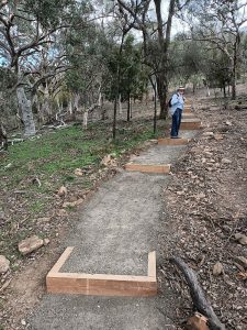
Kosciuszko National Park 27-30 Nov 2019 Tabletop to Brooks Hut – Arsenic Ridge Track
This was a 4 days and 36.3Km medium-hard walk. The objective was for our small team of 3-5 walkers to walk the old Arsenic Ridge walking trail from Brooks Hut to Boltons Hill Trail and an extension along the upper Temperance Ck valley to just east of Tabletop on the Tabletop Trail. We had approval from the NPWS to survey and tape the best route. This will create a nice short cut for walkers on the Australian Alps Walking Trail (AAWT) as well as reinstitute part of an old historic route from Victoria to the NSW Kiandra Gold Fields, called Ligar’s Route.
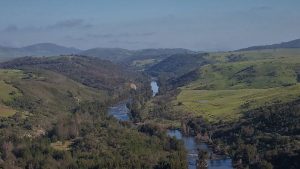
The featured image is a view of Lake Eucumbene from Happy Jacks Road
My pictures of this trip are available on Google Photos
Introduction
This walk was really an adventure. It was a privilege to be part of a small team that was to rediscover and work out the best alignment to reopen the old Arsenic Ridge route from Tabletop to Brooks Hut and thus the Happy Jacks Road. This concept was conceived by Robert Green who had previously authored a book ‘Exploring the Jagungal Wilderness’. I had known him for over 10 years and helped him find the route from Kidman’s Hut to the main range and then on to Mawson’s Hut.
Robert has spent some time conceiving the concept that some of the old tracks in the Jagungal and other areas were worthy of retaining and many had great historic significance having been used by the original aboriginal inhabitants and of course critical for many of the miners and cattleman who had leases for grazing sheep and cattle in the high country.
Robert has made some of his concepts quite public. In Dec 2017 in Bushwalk Australia’s Vol 26 magazine he published “Heritage Tracks” on pages 20-24. Here he outlined his fundamental concepts about preserving historic tracks and listed some that needed saving. Some of the tracks he mentioned I have walked and gps’d and found with careful navigating one can actually walk them, although the scrub can sometimes make it hard work.
Robert has more recently built on those concepts and in early 2019 put a proposal to the NPWS to recut the old Arsenic Ridge route from Brooks Hut to near Tabletop. In this proposal he was supported by David Scott, Graham Scully, Klaus Huenke and Mathew Higgins. They are all members of KHA and well know conservationists, authors and historians in their own right. He was also helped by the recutting of the Hannel’s Spur track and the fact that Arsenic Ridge in not technically in a wilderness zone.
Back in September 2019 Robert contacted various people in Canberra and elsewhere and we got together in a Yarralumla cafe and worked out when we could go to Kosciuszko NP and do the work.
It ended up with Robert, his old long term legal mate Paul Freed from ‘The Shire’, and I, Greg Hutchison agreeing to go there on Wed 27th November and start the survey and Mika Kontiainen & Stefan De Montis would drive down on Fri morning 29th Nov. We also agreed to camp at Happy’s Hut as we believed that it was a better spot to camp and for cars. At one stage we were going to use Brooks as a base site. We were unsure if we could drive across Happy Jack’s Creek where the rough access track to Brooks goes. Back in 2011-12 there was no bridge just a small deepish crossing. However it turned out NPWS had put in a newer culvert style bridge which made things much easier.
Robert contacted NPWS and was sent two keys and some biodegradable tape that we could use to mark the route. We also found out the keys would open the gate near Eucumbene Cove as well as on the Khancoban Road. We didn’t know if it would open the gate at the Happy Jacks crossing to Brooks Hut, but it did thankfully.
The following are my records of what we did and meeting cyclers from the Hunt#1000
Our Trip
Day 1 – Wed 27th Nov 2019
I left Canberra around 6.17AM and drove to Cooma where I had coffee and some breakfast at Maccas. I then went into Cooma proper, refuelled as I didn’t know how much driving I would be doing and sat in the car and waited for Robert and Paul to arrive. I had agreed to meet at the first coffee shop right on the first main roundabout. Luckily they arrived by 9AM and we had some coffee and Robert gave me a welcoming pack which included his overview of the task and some old maps. I had also created my own maps and gpx file which I loaded onto my GPS. Whilst helpful we certainly made significant changes to the route during our trip; although the fundamentals of the route remain as they should have.
The guys bought some things to cook, some ice and we headed off for Eucumbene Dam area. It was simply a drive south of Cooma, turning right onto Rocky Plains Rd, then right in Eucumbene Dam Road and at Eucumbene Cove village taking the right level road onto Happy Jacks Road. Here we came to the first NPWS gate where Robert had some issues with getting it open then closed but it happened with minimal delay.
We drove along the dirt road taking a couple of quick stops to get pictures of Lake Eucumbene and the area which from the top of the range near Mt Hudson and Barney Gap are quite spectacular. The only stop we made was to a Snowy Hydro Microwave Radio Repeater site which was obviously a significant site as it has two very large dishes backed up by diesel generator in a large brick and stone building. I believe this was their main link to Cabramurra Tower which is close to the switching centre there. I think the tower sends signals to another site on Mt Wambrook off the Snowy Mountains Highway which then sends the signal to Cooma Headwaters via a reflector on a hill north west of Cooma.
We then turned left at the Tolbar-Happy Jack’s Rd junction and went down Happy Jack’s Road until we could turn off onto the grass track to Brooks Hut. We managed to open the gate just before the bridge over Happy Jacks. The track in for the last 1.5Km was very bumpy and at one spot my vehicle was on a severe angle. I did stop and break off some dead branches. At Brooks we parked OK and I think we could have set up out tents OK. However we weren’t sure about the water supply. We also came across a middle age guy and his young daughter. They had come across from Happy’s that morning and were going onto Mackey’s. They had been saturated in a storm travelling from Broken Dam to Happy’s the day before. I think we convinced them to stick to the main tracks as they had to get to Guthega Power Station by Sat afternoon. They had forgotten their tooth paste, so I squeezed a hunk of mine into a plastic bag for them and gave then a small plastic toothpick. In the process I left my driving sunglasses in the hut, but I recovered them 2 days later when we came back to Brooks.
Brooks Hut GPS 637192 5991587 (verified on SIX maps).
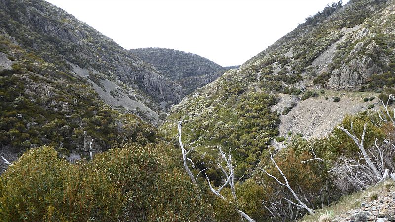
We then drove back out to Happy Jacks Rd to the Tolbar Rd, then went north onto the Tabletop Trail for a short distance then left and out onto the Happy’s Hut access trail. We had lunch at Happy’s around 1PM but didn’t setup our tents as we wanted to get to Boltons Hill Trail and do some surveying up to Tabletop. Then we piled into Rob’s RangeRover and drove up to Boltons Hill Trail and parked near where I had determined was maybe the best spot as it wasn’t far from water and was open. Around 2.28PM we put on our gear which was largely day packs and good boots/shoes and headed off along the eastern side of Temperance Ck valley. We didn’t really tape any points as we were just checking and working out the best route. We actually made great progress and I think we were fairly close to an old track. In a couple of spots you could see the signs of an old track as there was some benching involved and it looked like others had walked the same route at some time.
We crossed Temperance Ck where I had previously been several times and went up the ridge where the track had obviously gone. We moved to the left and went down close to an open gully to the south but made a note that we should try and find a route down the middle of the ridge. We then went across an area we had named the Swamp although from my early memories back around 2011 it had then been less scrubby and many rocks and pools were there in that October. We struggled to find an old rut that had gone across but eventually we came on it.

Instead of going up through obvious scrub I suggested we track north around the contour and maybe look at a 4 foot drop in a race and even visit the main race Takeon for 9Mile below the old airstrip. We tried this but it got scrubbier and thicker as we went along. I even missed the race drop but we went back and saw it. With all the scrub around it was not as impressive. It looked thicker so we decided to go uphill towards the old SMA emergency airstrip (ELG) and then the old Tabletop Hut ruin. So we backtracked a little and went up. It was quiet scrubby for several hundred metres until we closed in on the ELG. Once there it was across it to the old hut site where we took pictures. We then went up to the Tabletop Track some 150m away. We did see some roof tiles upside down laid over the grass and thought it must be some experiment for some rare species. From the main trail we then went east for 200m and found the cairn that signifies where one could turn off for Temperance Ck. We followed my old waypoints down to the swamp area deciding that we needed to come back and find a better way down from the top point T3 down to the Swamp at the white rock, which had been my point T6. The next day we did find a better route.
From the swamp we tried to follow points down the valley to the south east which we did but did not find any evidence of a track. We rejoined the way we had come up along the ridgeline north west of the Temperance Ck crossing. We then followed the way we had come trying to fix some of the route and adding tapes to make it better. At a point 220m from Bolton’s Hill Trail we stopped for water at a small tributary of Temperance Ck. It always seems to have nice cool clear water and would be the last spot for water before heading down Arsenic Ridge.
We reached the car by 6.12PM and were quite late back at Happy’s to set up our tents and have dinner.
On Day 1 we walked 7.8Km.
Happy’s Hut GPS 638725 6013661 (verified in SIX Maps).
Day 2 – Thu 28th Nov 2019
We awoke early to a cool bright sunny morning and with a relatively dry tent. However we discovered someone sleeping on the hut’s verandah with a pushbike standing nearby. Egads an intruder.
Turns out Matt Brough was a rider in the Hunt#1000 mountain bike event from Canberra to Melbourne through the mountains. He had started at Lonsdale St, Braddon, Canberra on the same morning we had set out and he had cycled through Canberra, Namadgi ie the Boboyan Rd to Adaminaby, then Snowy Mtns Highway, Denison, across the Eucumbene River then up the Tolbar Rd, Tabletop Trail and to Happy’s arriving at about 1.30AM. Some of us heard the noise but thought it was a wombat or possum on the verandah.
We engaged Matt to learn what he was up to and were dumb founded somewhat. Matt had a lot of gear and some good comms stuff including INreach communicator as well as good maps on his phone. He planned to cycle right along the Greymare Trail down to Geehi Dam then Geehi Flats for the next night. The Hunt 1000 is a special ride for bikepackers a type of superman race on bike which could be started in Canberra on 26, 28, 30 Nov to finish in Melbourne on 7th Dec. From what I can deduce online Matt did finish at 7.30PM on 6th Dec near Fitzroy North. Well done that was an amazing ride!

We then drove two vehicles up the Tabletop trail. I drove my Subaru Forester which had trouble getting up a stony and slippery short section. However on the 2nd attempt I went slightly right and got up. We left my car on Bolton Hill’s Trail and the three of us went around and up the Tabletop Trail in Robert’s vehicle. Even he in his RangeRover had some issues with rocks and I think he hit two of them. We stopped and parked around 250m from where we left the Tabletop trail the previous afternoon and started walking at 10.02AM and reaching the Cairn we went downhill trying to refine the route and taping it. From my old points T3 we went downhill more northerly and came back up to that point further refining the route to avoid scrub and trees. We more or less achieved this goal then we stopped near my old Point T6 around 11.42AM for an early lunch. We resumed about 12.32PM and headed south across the swamp and found a better route down the middle of the ridge through the upper forested section.
Now we split into two with Robert and Paul going back up to his vehicle refining some of the tape points on the way.
I went back down the ridgeline to the Temperance Ck crossing putting in some more tapes where they were not easy to see or one could see the next or last tape. I also had to take off my footgear and add some bandaids on one foot. Yep I had new boots although this was their 2nd trip. As I approached Bolton’s Hill Trail I stopped for a drink at the creek as I was getting thirsty and I could see these bodies lying in the grass watching me climb back to the car. The sods had walked back up and driven the car around and beaten me to Bolton’s Hill Trail where I had parked.
They then headed back down to camp whilst I went south on my route down Arsenic to around SMA396 point (note we never found these point) and then returned to the car by 3.50PM which was not very late and drove back to Happy’s carefully.

I had walked 7.6Km this day including a diversion down Arsenic Ridge of about 2Km total return
Day 3 – Fri 29th Nov 2019
We took it easy as we were supposed to meet Stefan and Mika at Happy’s between 10AM and 11AM. After thinking things through we decided to place my car near Brooks but at the Happy Jacks Crossing and then drive at to the Tolbar & Happy Jacks Junction to wait for the guys before directing them up to Boltons Hill Trail.
We waited and waited and then had lunch at the junction. No guys. We then decided to go up to Boltons Hill and started surveying the route down. Hopefully they would go to Brooks and walk up and meet us.
When we got to Bolton’s Hill Trail guess what we found. The guys in Mika’s SUV getting ready to walk.
As it turned out they had come down the Boboyan Rd, to Adaminaby then along the Khancoban Rd and came in past Happy Jack’s Dam and they must have snuck past us while we were lunching. The junction of the Tolbar and Happy Jacks Roads is a large triangle and they had turned over the part of the triangle we could not see. They had also come in the gate that we didn’t anticipate.
From 1.02PM we then walked as a group mostly although I deviated off to the ridge route initially and then we walked up an alignment that more closely followed the old SMA map. There were some ruts and across the top of Mulligans Ck. However then the route to Roberts planned Point 6 did go through some horribly thick scrub. Whilst several of us went higher Robert punched straight through and around to the west and then we had trouble finding him for a while. Once we found him we stayed together and moved down the main ridge but on this pass we seemed to be too far east until we went hard west to try and find his Point 5. From around here we then generally went down in a logical fashion until we reached the grassy saddle were we crossed diagonally.
Form here Robert and Stefan led around the hill which represents SMA397 but on this pass we ended up around 100m too far east, and downhill. Passing the hill we rejoined the ridgeline and followed it down. We then went down too far east compared to our final pass. However at one point we ended up west which had a series of flat rocks which offered great views south to Jagungal and west to Far Bald Mountain and over the Happy Jacks Plain to the south. We nicknamed this place ‘The Rock’, but maybe ‘Stef’s View’ might have been better. From here we seemed to swing east again and eventually we went down a horribly steep and scrubby hill and then a short flat trudge to Brooks Hut.
Robert always talked about a well at Brooks but I had never seen it. This time we went downhill east of the hut and maybe a little south and maybe around 40m from the hut.
Brook’s Hut Well GPS 55 H 636952 6011639
Several of us filled up our water bottles including some flotsam that came with the well. The water appears OK to drink but use of a filter would allay fears to keep out bits and pieces. The well seemed to be concreted and you can bend down and fill up containers OK
After a break here we headed back up. However we changed our route and went up the first creek you come to north of Brook’s around 300m. I remember this creek providing water back in 2011/12 but it looked dry on this day. On the way we passed 10 roof tiles laid out on the ground and probably another trial for some species.

We went back up the ridge and initially went too far west until The Rock, after which we went up to SMA397 in an alignment that was close to our final route. However we went around SMA397 too high. We should have also gone up to the top which is easy as it offers views out west and east over Upper Happy Jacks Valley.
From the Grassy Saddle we went west up the ridge in an alignment that was close to our final pass although over the top portion we were too far east, however we reached our cars. We finished our walk at 5.49PM and then drove back to Happy’s in the two cars.
Unfortunately this left my car stranded at Happy Jack’s bridge on the way to Brooks with most of my food in the car. Luckily I still had coffee bags and some muesli bars and nuts. That night I had to eat some of Robert and Paul’s meal and for the following breakfast their cereal and milk as well.
Today we did 8.8km.
Day 4 – Sat 30th Nov 2019
This was our last walking day searching for the best Arsenic Ridge route.
We got up early as we wanted to finalise the Arsenic Ridge section today.
We drove in two cars around to Brooks Hut leaving my car isolated and stranded at the Happy Jack’s bridge again.
The weather looked like it was deteriorating with some rain expected. So most of us put on raincoats and even overpants.
We left Brooks at 8.49AM and went up a different place ie we only went north around 50m, to reach the ridge above. It was steep but negotiable and only a 30-40m climb. After reaching the top it flattened out to a nice wide plateau or ridge. We did walk north after finding our way around some scrub and trees. I had to put on my raincoat as I was getting wet in the light rain.
Robert kept pushing us towards the east to try and pass his old point 2 but by the time we reached that area we were above his point. We continued up past a small overhang which was really too small to be useful as a shelter. We also revisited The Rock as its views west and south were too enticing to ignore it. However we could see dark clouds out to the west. Light rain was annoying me as I was continually wiping my GPS. As per the previously pass we found an easy way up the middle of the ridge as we approached peak SMA397. I went up onto the open top, but lower than last time expecting to then track down to the grassy saddle. However Robert and Stefan worked behind me to cut through at a lower level and in the process pushed through various bits of scrub to make a more direct route through to the grassy saddle. Eventually they made it through and I dropped down a little to join them and recommence GPS’g. I didn’t go back to pick up what I missed as I knew we were coming back again today for another pass at the Ridge.

We all met at the Grassy Saddle again and then continued up on the western side of the upper ridge doing the usual zig zag around any thickets or trees. However this time we straightened the route a bit and taped a lot of trees. Near the top we kept deliberately west and went over the end of the natural ridge as it swung right. We then made it close to Roberts old Point 6 and then pushed through some scrub until we reached a point where we could see across towards the Boltons Hill Trail. We had already taped that route ahead so we stopped for a bit of lunch. It had ceased raining although it still looked threatening. Mika had arrived from a slightly different route and advised us that there was a less scrubby and straight forward way back to near the old Point 6.
So we headed back clearing a little and taping our way back to Point 6 then continuing down the way we had just come up the upper ridge. On the way down we made several improvements to the route so I was continually making new GPS points to cater for the adjustments. We also had to remove numerous old tapes as we continued to adjust the route. Near the bottom we had to make several reroutes to straighten the overall route and that includes removing lots of dead branches that seem to cluster around clumps of trees.
We all wore gaiters, except for Robert so we were mainly not too fussed about low level scrub, however the route if accepted and recut should remove most low level stuff. Not sure how Stefan could wear this short shorts which I conjectured he had borrowed from John Evans (an amazing Canberra walker).
We reached Brooks again at 3.03PM with the weather now improved and sun now shining.
We had done 8.6Km today just on Arsenic Ridge. That’s only my reading. Some of the others may have walked further.
We then debated whether to drive over to the Greymare Trail and look for another hut site that had intrigued Robert for quite some time. We had little information on the site with a parish map being the only guide. We didn’t even know its name. However the area was tied up with the Whittal run in the Clear Hill parish. We decided to drive over there and get it out the way as we had sufficient time and it was easily accessible.

Whittal’s Hut Site south of Mckeahnies Creek
So we left Brooks for the last time, and on the way I picked up my lonely car and we drove to the junction of Happy Jacks and Greymare Trails. We all piled into Roberts car, 5 was a squeeze and we drove along the Greymare through Barney Creek and then McKeahnies Creek and parked by the side of the track 500m south of the last crossing. At 3.35PM we then walked a bit over 1km up the valley to an area on the parish map that showed there might have been a hut there.
On the way up Mika found a small mound with a rectangular small depression on the west side. There were small rocks buried under the grassy mound. I was close by and GPS’d the site and took a picture. We then went up the grassy site to where the others were. We then walked across the scrub above the field looking for any sites. We did find an old fence line which we guessed was the property southern boundary. We went down to the site we had found earlier and discussed if it could be a hut site. It had many of the ingredients of an old hut site, was close to a fenceline just north, was a nice open grassy area, there was a creek 3-50 metres to the west. However leader Robert did not agree as there was no metal or wood lying around nor trench on the high side to run water away.
However given the portion map, we had Portion1, Clear Hill, the overall positioning of the site it is likely it was an old Hut site
Possible Whittal Hut site GPS 55 H 636868 6005787.
We then went back to the car around 5.21PM with Stefan nearly treading on a small Copperhead snake. This was the only one we had seen.
We rejoined our cars and returned to Happy’s Hut about 6PM for our last night.
Today I did 8.6Km on Arsenic Ridge and another 3.5Km around Whittal’s site ie a total of 12.1Km.
Soon after we got back to the Happy’s we saw a bicycle approaching across the plain. It was Stuart Dun a Scotsman and a participant in the Hunt1000. (Stuart did finish the Hunt1000) Soon after Stuart appeared more cyclists arrived in singles and pairs until we had around 10 camped with us. It was a cool night and we had the fire on in the hut. Some of the bikers were lucky enough to score a Furphy beer from Mika’s cache and even a glass of Vino Rossi from the rest of us.
We had finished our diners earlier than most of the bikers so we let them used the table space inside to cook whatever they had.
I think I went to my tent around 9.30PM and read for a while. However I had to get into my sleeping bag quickly as it was freezing. That night water froze in water bottles and I believe a few of the guys were quite cold. I think it had snowed in the alps above 1600m. Lucky we were only at 1500m.
Day 5 – Sun 1st Dec 2019
We awoke around 6AM as usual and had breakfast. All around us the bikers were eating their morning meal and getting ready to push off. I think they were all heading through KNP for Geehi Flats. The last guy who was an older ADF member took a picture of the five of us before he left.
We had all decided to drive up to Happy Jacks and all head down through the gorge to Happy Jacks Dam and out via the Khancoban Road but leaving via Cabramurra , Kiandra and either Cooma or the Boboyan Rd.

On the way we stopped several times to take pictures, we also stopped at the old Happy Jacks Village and several of us had a look around, and at Happy Jacks Dam where we walked the wall and took photos. We also stopped at the quarry site near Dodger Ck and looked straight down into the abyss of the gorge where a landslide from the quarry has block part of the creek. All down the gorge on both sides were rock slides with some very high and steep ones above the road. It looked quite dangerous along that road.
We all said our goodbyes at the gate near the Khancoban Road gate with Robert and I driving north to Kiandra and Mika just going south to Round Mtn carpark to wait for his partner who had spent the weekend near Mt Jagungal.
I stopped at Cooma briefly and was home around 3PM
Is Arsenic Ridge Route Shorter than Tabletop Trail – Tolbar Road – Greymare Trail
The Arsenic Ridge walk will be 6.9Km plus Brooks trail to Happy Jacks Rd junction plus a small part of Happy Jack’s Rd is another 3.1, or a total of 10.0Km
Walking north from Greymare & Happy Jack’s Rd junction then on part of the Tolbar Rd and the Tabletop Trail is 12.7Km. So overall the Arsenic Ridge walk can save 2.7Km of boring road walk.
However many AAWT walkers go to Happy’s Hut and either walk back to the Tabletop Trail or bush bash up the hill to the north to rejoin the AAWT near the Tabletop and Bolton’s Hill Tracks junction.
The trip from Tabletop Track to Happy’s is 2.1Km each way so if a walker went to Happy’s and came back the same way which probably most do, the Arsenic Ridge option could say them this extra 4.2Km thus making a total saving of 6.9Km.
Distances
| — Date — |
— Distances per Day — |
—Km— |
| 27 Nov 2019 | 1. Boltons Hill Tk to Tabletop return | 7.8 |
| 28 Nov 2019 | 2. Tabletop Tk to Boltons Hill Tk & top of Arsenic Ridge | 7.6 |
| 29 Nov 2019 | 3. Boltons Hill Tk to Brooks Hut return | 8.8 |
| 30 Nov 2019 | 4. Brooks Hut to near Boltons Hill return | 8.6 |
| 30 Nov 2019 | 4. Greymare Tk to Whittal Hut site return | 3.5 |
| 1 Dec 2019 | 5. Drive home via Happy Jacks Dam, Kiandra | |
| Total | 36.3 |
Car Distances
The distance was 567Km from Belconnen, Canberra via the Monaro Highway, Cooma to Rocky Plains, then Eucumbene Rd, Happy Jacks Road, Tolbar Rd, Happys Hut Rd, Tabletop Tk, Brooks Tk, via Khancoban Rd, Kiandra, Adaminaby, Cooma, Home.
Relevant Topographic Maps
The topographic maps covering the area of this trip are:
1:50,000 older maps:
- Eucumbene, if you can get it for section Brooks to Bolton Hill Trail
1:25,000 newer maps:-
- Denison for section Bolton Hill Trail to Tabletop Trail
- Old Adaminaby for section Brooks to Bolton Hill Trail
I used Oziexplorer Mapmerge with the following 1:25000 maps Denison, Old Adaminaby, Cabramurra, Toolong Range to create a suitable map to show Arsenic Ridge and its surrounds. However the whole area of this track from Tabletop Trail to Brooks is covered by 1:25000 maps Denison and Old Adaminaby.
I strongly recommend that keen walkers check out the use of Oziexplorer from Des Newman’s OziExplorer plus OzRaster from GPSOz
Use of Oziexplorer with OzRaster maps for NSW enables you to load up a gpx file and see your route (and one’s available off this trip) on a modern topo map base
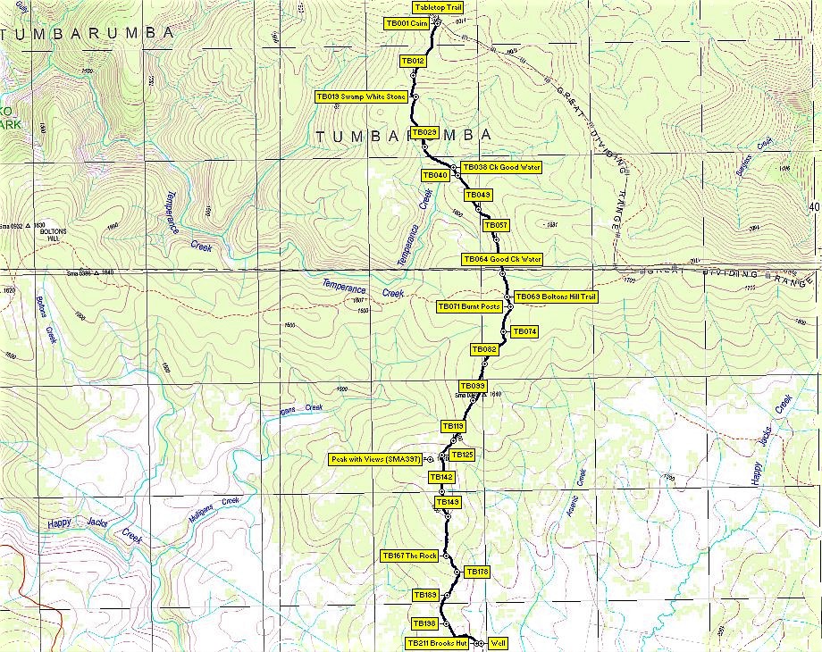
GPS Waypoint Numbering
The original numbering was all over the place with several patterns used. Once the track was finalised I renumbered all relevant waypoints from the top to bottom ie north to south starting at TB001 cairn adjacent to Tabletop Trail and finishing at TB211 at Brook’s Hut. The simplified maps only show some waypoints yet the main gpx file has 211. TBxxx means Tabletop Trail to Brook’s Hut. A public version of map has more Waypoints shown on the map then the original simplified version but the gpx files included all 211 waypoints.
Produced Maps, Pictures and Documents
One Google earth kml file, one gpx file and one Garmin gdb file covering the trip with waypoints and daily tracks are in a Google Drive folder.
On the screen captured Oziexplorer maps:-
Oziezplorer Maps using NSW Ozraster Base Maps:-
A: Shows Edited data with one track and all relevant waypoints renumbered
- Days 1-4 – “KNP Nov 2019 Tabletop to Brooks – Arsenic Ridge Overview NSW Topo Base using Oziexplorer.jpg” – whole route
- Days 1-4 – “KNP Nov 2019 Tabletop to Brooks – Arsenic Ridge 1 NSW Topo Base using Oziexplorer.jpg” – north section
- Days 1-4 – “KNP Nov 2019 Tabletop to Brooks – Arsenic Ridge 2 NSW Topo Base using Oziexplorer.jpg” – south section
- Day 4 – “20191130 Walk Whittal Hut Area Ozraster Maps NSW Base.jpg” – area McKeahnies Ck & Clear Hill Parish
B: Shows Edited data with one track and a reduced number of waypoints renumbered just for viewing purposes
- Days 1-4 – “KNP Nov 2019 Tabletop to Brooks – Arsenic Ridge Overview NSW Topo Base Reduced Waypoints using Oziexplorer.jpg” – whole route
- Days 1-4 – “KNP Nov 2019 Tabletop to Brooks – Arsenic Ridge 1 NSW Topo Base Reduced Waypoints using Oziexplorer.jpg” – north section
- Days 1-4 – “KNP Nov 2019 Tabletop to Brooks – Arsenic Ridge 2 NSW Topo Base Reduced Waypoints using Oziexplorer.jpg” – south section
On the screen captured Mapsource Maps using Oztopo Maps – This shows the immensity of all the raw tracks and waypoint data pre editing:-
- Days 1-4 – “Tabletop-Boltons Raw Data.jpg”
- Days 1-4 – “Boltons-Brooks Raw Data.jpg”
Notes: Map view extracts came from Oziexplorer using Oztopo Ozraster maps for NSW © BKK Enterprises Pty Ltd, http://www.gpsoz.com.au with the source date from Spatial Services, DFSI NSW. GPS files available on Google Drive. Map view extracts also came from using Garmin Mapsource using Oztopo base maps with permission of © BKK Enterprises Pty Ltd, http://www.gpsoz.com.au
The trip maps and sketches showing the trip tracks and various waypoints of important locations are available in a folder in Google Drive and the Final Map(s) are also in the Google Photos album. The Oztopo Trip Maps produced using Mapsource are in a sub folder
Greg Hutchison, 11 Dec 2019