21-24 Nov 2000 – Trip to KNP Gungarlin – Kidmans – Mailbox – Bulls Ck area – Snowy Plains – Daveys Hut
This was a 4 day backpacking trip from Gungarlin River to Kidmans, the Mailbox, Bulls Peak Ridge, Bulls peak Hut, Flanagans Hut, High Hut, Katingal Hut, Snowy Plains. This was my second trip to this area in Kosciuszko National Park in 2000 but was slightly different.
This is posted to document an old walk for historical purposes only.
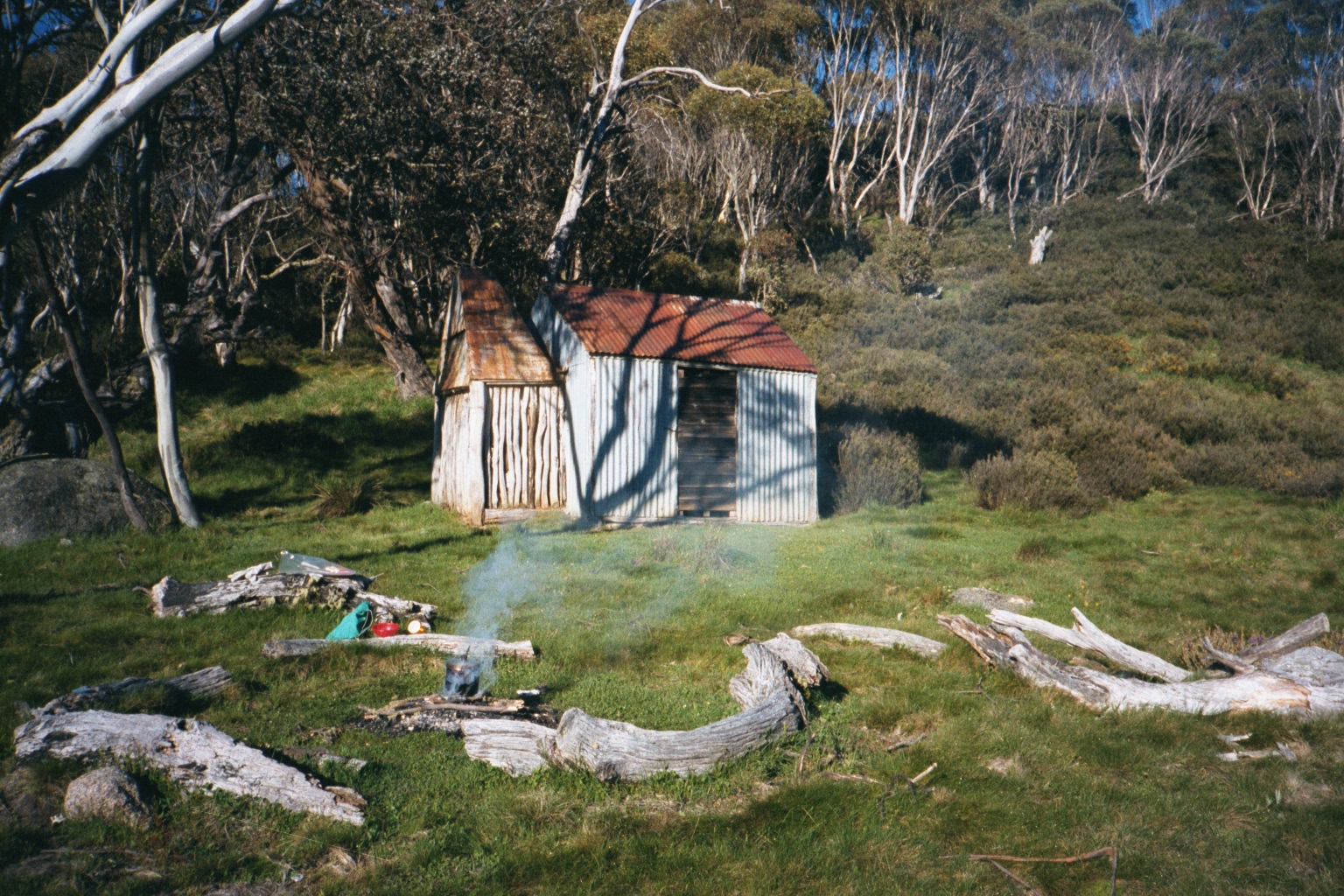
Featured image is Kidmans Hut 2000
Day 1
I parked my car at the Gungarlin River camp area which stretches along the north side of the river for a 100m or more just below the bridge across the river. It the end of a 17.5Km dirt road trip from the Rocky Plains to Eucumbene Dam Road. The road is not the best and its desirable to have at least an SUV with high clearance.
I walked with my pack across the bridge and along a management trail that heads west across the southern edge of the Snowy Plains, past Daveys Hut with the option of a side trip to it if desired and then continues on to the site of the Snowy Plains House (also known as Napthalis) where there are still obvious signs so as you can see the site of the hut, the area in from which had a tennis court and some yards just to its southwest next to a gate on the trail. The yards and gate are now fallen.
Its an easy trip along here and if your lucky you may see a brumby or two. Sometimes you might see none and some cattle might be on the plain near Daveys. They often escape through the fence from the property that is just north of the park. The trail continues and runs parallel to Teddys Creek. The trail crosses Teddys Ck twice before heading up a ridge and heading south-west and parallel to Collins Ck to its east. Just before the last crossing of Teddys Ck there is a side track that is indistinct initially but it runs north away from the creek and eventually up and over a ridge line ending at a gate to neighboring property known as “The Barley Fields”. There is also an offshoot that heads back to the north-east ending at the fence to the Jardine’s property.
I headed up the trail to the south-east which was the main trail from this area up to Kidmans and then onto the main range and Kidmans, Tin Hut, etc.
Its a long slow slog up from Teddys Ck at about 1390m to the gap in the range known as Little Brassy Gap at 1610m after which there is another long trudge this time mostly down to the Burrungubugge River and a short spurt up to Kidmans Hut.
The way down from the gap is intricate and requires crossing around 5 small creeks and carefully looking for cairns or markers indicating the route. It initially starts off as two well worn ruts of an old 4WD and deteriorates into a series of foot pads requiring one to just head in the right direction. In 2000 it was much easier to follow but the post 2003 fire periods has created a spurt in scrub growth making things harder.
I got to Kidmans in late afternoon taking around 4-5 hours from the car.
Day 2
I went up the hill behind Kidmans, then across an open field and then up through some bush until reaching another area of open fields which you have to negotiate before crossing and small oipen valley with a creek in the middle before then finding another field which you then head south down towards the Burrungubbugge River. Close to the river you need to turn right and pass through 50m of bush before crossing another open but swampy area before just passing the edge of the river. The its generally a slow climb up a small gorge over largely rocky ground until besting a final climb open in an open high valley with the Burrungubbugge on the left with the McDonald Diggings on its opposite bank. These are several large piles of rocks as well as a water race that you need to walk over. After around 100m it is possible to cross the river with some rock hoping, although in the Oct – Nov snow melt period it can be a little deeper. Its a good idea to rest here, drink some of the clean water and take in the view. I then headed slightly left and reached more solid ground heading for a clump of trees several hundred meters to the SW. At this point you could turn left and head south to a small saddle you could see on the horizon. The old trails cross a small swampy ares and kept to the left before heading over the saddle and on to the burnt out Alpine Hut site. However I turned right and went uphill to a small meadow and close to the river again, before turning left at a cairn on a rock on the left which indicated the route of the old bridle trail up to the main range.
I then went up the bridle trail I know so well until reaching a high plateau covered in swampy type low scrub and the source of the Burrungubbugge River. There is a cairn on a high rock which indicated where you turn left for the main old trial up to a gap near Brassy Peak or right to cross the Burrungubbugge and then wind your way up to the beginning of the Bulls Peak Ridge of the mailbox area directly. This time I can not remember exactly but I think I went the south route towards the Brassy Mountains and then past a gateway and turned north and took the eastern edge of the plateau north towards the Mailbox. Ome of the pictures shows a cutting below the Mailbox which would have been best reached via this route.

I did camp on the Mailbox this trip, the only time I ever camped there. Its quite campable in its middle towards the western side and you can get good views out west ans south. There was water a couple of hundred metres east where there is circular high valleys that drains east and probably to the Burrungubbugge. So really the mailbox is the source of the Burrungubbugge.
Day 3
The wind came up and nearly blew me off the top, so I got up early and packed up and went along the old Bulls Peak ridge trail, stopping for breakfast when out of the wind, then down an old bridle route to Bulls Peak Lodge, past Flanagans Hut to Katingal Hut. From the latter you can see the new High Hut to its north.
I then went along the 4WD into the Barley Fields and across until I could enter KNP and had to stop several hundred metres into it as I felt sick. I put my tent up and lay down for a while. I think I had heat exhaustion as it had been a hot day. I had worn my beanie rather than my hat and I had a touch of heat stroke. By night fall I felt better but stayed camped here as there was plenty of wood, water and grass.
Day 4
I woke very early to howling wild dogs very close by. I was so scared I packed immediately and walked down south to junction of Collins and Teddys Ck and had a late breakfast there. I then continued down Teddys Ck trail and across the open fields to Daveys Hut and the the Gungarlin River campsite.
I then took it slowly along the Pipeline firetrail (as it is also known) until reaching the bitumen and thence home.


Nice walk Greg. Lots of regrowth atm. Saw that large cairn on Bulls Peak Trail a while ago. Is that where the bridle trail goes down to Flanagans. Can you drive up to Flanagans ?
Hi George. I think its OK to walk up there but I believe the gate near Flanagans might be locked. I think the SnowyVale mob’s property cuts across the trail upstream from Bulls Peak. Its best to either park on Snowy Plains near where the trail to Bulls Peak Lodge & Flanagans etc turns off. You then have to go through the Barley Fields and gates each end before it goes past several tracks off to to lodges including the old Katingal before reaching Bull Peak Ck. Crossing Barley Fields in 2WD drive would be dubious as it has several parallel deep ruts as the access track and it is private property. Unsure of its ROW status. Flanagan is on the property owned by the Bulls Peak owner. It used to be a Canberra solicitor but I heard he was trying to sell it. There is an old access track just before you reach Bulls Peak Lodge and it takes off on the right and goes steeply uphill winding a bit to the south. It peters out but if you go straight uphill you will get to the big cairn on a rock. You can of course drive straight along Snowy Plains Road and up to the park gate around 2-3km before Cesjacks. Its public all the way. Only issue is Bulls Peak Ck crossing which can be dubious after heavy rain or in the snow melt. There is also another nasty deep small creek before Bulls Peak Ck. Stefan de Montis apparently wrecked his Subaru on that creek and had to get it towed away. I have seen you on Facebook conversing with Stefan and you might ask his advice. I think he likes parking next to Bulls Peak Ck on Snowy Plains as there is a footbridge over the creek and you can walk up the road to Cejacks. Of course he walks at 25kph.
Thanks Greg . My BT 50 had no problems with road to park boundary twice recently- once after a good bit of rain. We did a route to Spencers Pk by getting onto the divide early via an unnamed peak ( south of Spencers) with cairn. Spencers was relatively good going- not much bushy stuff , by approaching via the SW ridge. Tibeaudo Ck had lots of long grass- annoying to push through. Following the Diggers aquaduct around till oposite Boobees was quite easy but long grass on Happys again. Things are growing lots. Going back up Doubtful Creek was beautiful but now quite a bit of scrub work