2021 05 13 Rendezvous and Middle Creeks – Namadgi National Park
This was a 16.1Km walk from a car park on Boboyan Road next to Rendezvous Ck in Namadgi National Park (NP) ACT, Australia. We planned to visit Nursery Swamp but due to a washed away bridge we decided to walk along Rendezvous Ck and then across to Middle Ck and return.
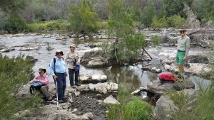
Featured image – Greg at Middle Ck Rock Shelter
I drove to Drew’s place in Belconnen and we set out down the Gungarlin Drive and Tuggeranong Parkway around 7.25AM, then across the Murrumbidgee Bridge at Tharwa and into Namadgi National Park intending to drive into the Orroral valley and then walk up to Nursery Swamp. Little did I know that the bridge across the Gudgenby River, as one would turn down from the Boboyan Road, had been washed away in the savage downpours of March this year. So as we approached the turnoff on the Boboyan Road we were obstructed by blocks across the road.
We then continued down down the Boboyan Rd to Rendezvous Creek where we parked and decided to walk up Rendezvous Ck valley and maybe go south into Middle Ck to explore. I hadn’t carried extra maps nor any GPS data expecting to be walking elsewhere.
Thus from 8.40AM we set out and walked along the little Rendezvous Ck trail before taking a route across open fields and past numerous roos to reach the 4WD track that goes up the valley. Instead of walking right up the valley we then turned south and headed over the hill to Middle Ck. We continued past the Middle Ck rocks and rapids and then had difficulty crossing the ck as it was flowing quite fast. However we did cross on a fallen log and then went south to the old 4WD track and stopped for a morning break. We then headed west along the old track which was quite wet in places until we reached the end of the trail opposite the Middle Ck Rock Shelter. Again it was difficult to cross the creek as the shelter is on the north side.

So we headed upstream, the cross the first side creek on the south and continued upstream on the south bank for another 500m before we could again cross to the north bank. This bank was then quite high above the creek and gave us a good view of it further to the west. It looked quite reasonable and maybe I will come back and head up it to Mt Namadgi.
We stopped for lunch then headed downstream to the Rock Shelter which is interesting but nothing outstanding. We then both got across the creek but each finding our own way, rejoining opposite the Rock Shelter.
We then went down the trail and out onto the open ground and around and cross Middle Ck again on a proper road. We then crossed and took a trail over the ridgeline and into the Rendezvous Valley again. We decided to strike out for the western bridge and took a gps bearing to it. We then reached the car round 3.28PM. We tried to reach the park HQ near Tharwa before they closed, but they must have closed the doors at 4PM sharp, as we arrive at 4.05PM and it was closed.
It was a solid type walk with only minor climbs of 16.1Km, taking 6hrs 50m, 8.40AM to 3.30PM.
I rang the Namadgi visitor centre the next morning and found out about the Orroral Valley. The bridge across the Gudgenby River had been washed away in the March 2021 severe rain downpours. However the Valley was open but access was only available by driving to Honeysuckle Ck to its north and taking the dirt management trail by foot down the steep terrain into the Orroral Valley and walking elsewhere as desired. However that makes a day walk to the Nursery Swamp area a very long return trip adding around 25Km to the normal walk. Yikes!
The possibility of getting the bridge replaced is low as its technically outside the park boundary and relies on ACT Roads rebuilding it. Apparently its a difficult engineering task and there is no budget for it. More yikes!
OK options are to walk into Orroral Valley from Honeysuckle Ck and camp in the valley then walk up to Nursery Swamp and return to the camp, and then walk out.
Map of walk | Pictures in Google Photos | files including gps located in Google Drive
Notes re Map: GPS Map View using OZtopo Map with permission of © BKK Enterprises Pty Ltd, http://www.gpsoz.com.au | The area of the walk is covered by the NSW 1:25,000 topo map RENDEZVOUS CREEK