2020 11 25 Four & Eight & Nine Mile Diggings with David Scott (Kiandra 19)
This was a 5 day driving and walking trip to and around 9Mile Diggings, then back and down to Four Mile Creek Diggings and finally 8 Mile Diggings with David Scott. David stayed on and did drone surveys around 4 and 9Miles and a walk down 15 Mile to the Main Sluice area and below with another friend. Actual walking distance was around 35 Km.
This was all within Kosciuszko National Park just south of Kiandra along the Snowy Mountains Highway. This was a continuation of many similar trips to 4&9 Mile Diggings since 2011 and in particular my last trips Kiandra Trip 17 of 2-5 October and Trip 18 of 1-4 Nov.
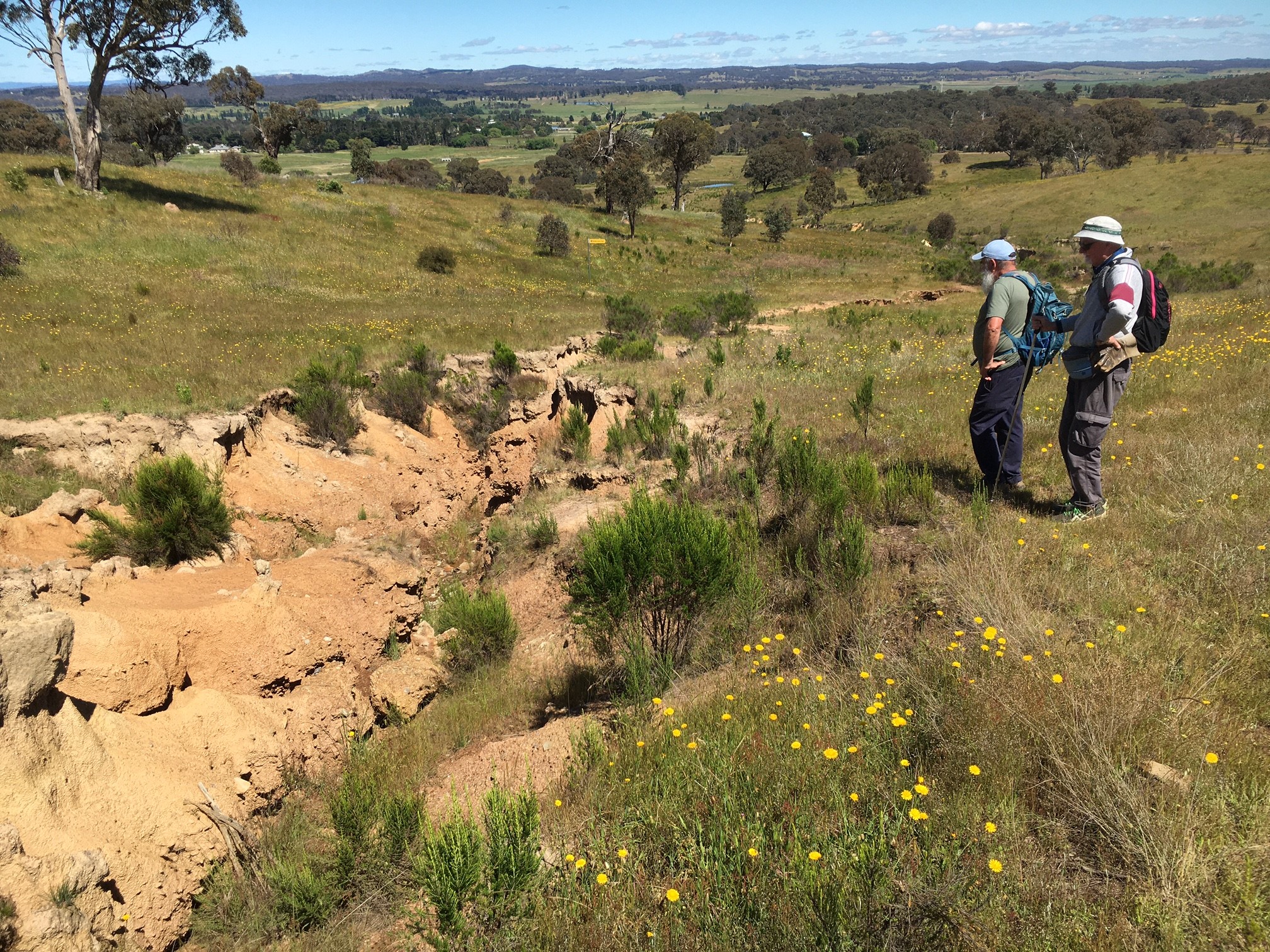
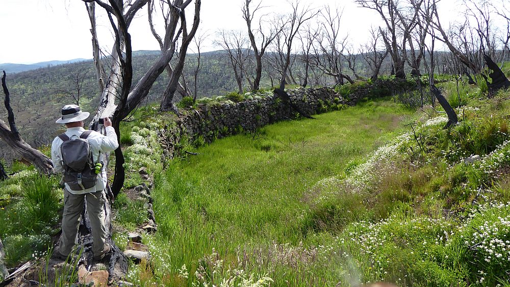
The featured image is a picture of David Scott at the South Bloomfield Main Header Rock Dam several Km’s south of Four Mile Hut site
More pictures on Google Photos
25 – 29 November 2020 – Four & & Eight & Nine Mile Diggings & Nth Bloomfield (Kiandra Trip 19)
Purposes
The purposes of the trip were to check out more areas of 9Mile Diggings I didn’t see on my last visit as well as to find the source of another race that may have fed water to the South Bloomfield Rock Dam. I also planned to spend more time at 4 Mile Diggings as I didn’t give it enough attention last visit and lastly to check out some more sites at North Bloomfield. I also planned to recheck some things at Basalt Diggings, Giandarra and 12 Mile Diggings if I had time.
This trip was one of many over several years checking mining and other historical sites around Kiandra to help historian David Scott and ultimately Kosciuszko Huts Association (KHA) with documenting European historical activities within Kosciuszko National Park (KNP). In the process many hut and mining sites have been found, GPS’d and photographed.
Items of Interest
Some things I noticed on this trip, different to my earlier trip this year was the large amounts of wildflowers now evident all around as well as significant grass growth since early October. Also the flies were now out and march flies were also around.
There is an associated Site List in excel format which was compiled from saving the gpx file as text format and loading into excel. It was heavily edited as I found numerous duplicated waypoint entries, some missing which I was able to fix and I added a few sites from earlier trips and some comment points to give context to the sites.
25th Nov- Day 1
I drove around 220Km from Canberra to Kiandra. I left around 9AM so as I could get to My Selwyn long stay car park around midday. The trip and accesses had been organised by David Scott, historian working on a large database of sites for all the Snowy Mountains. Currently he is concentrating on doing a Thesis for Lincoln University in NZ where he previously worked. He currently lives in Geelong, Victoria and was only able to get out of Victoria a few days before due to the COVID19 border closures. He had organised with NSW NPWS Tumut office to get permission to go to Mt Selwyn as well as drive into Nine Mile Diggings, as well as also drive along part of the Link trail to visit 8Mile Diggings and later visit 15 Mile Diggings using Happy Jacks Road. Luckily the permission in writing had come through the previous day and I printed out the authority as I needed it to get past a checkpoint at Kiandra on the Cabramurra Link Road so as I could meet David at Selwyn. Coming from Geelong he had a long drive up to Tumut to get the keys and then drive back south to Selwyn.
Luckily he turned up around 12.30PM so I didn’t have to wait too long at Selwyn. In the drive in I had to pull over along the Link Rd and allow 20+ large semi-trailer tracks in a convoy pass by me. This is part of the effort by Snowy Hydro for Snowy 2.0. Also driving along the Snowy Mountains Highway I was delayed by long road works just near the park boundary. They were also doing road widening work on the Link Road and I could see that all the marks on the road suggested they were going to do more right through to the Lobs Road junction at least.
David turned up around 12.30PM and we decided to take my Forester into 9Mile Diggings initially, leaving Davids vehicle at Selwyn. We thus headed along the access road, got through the gate OK and out onto the Tabletop Trail with no problems. We decided to try and drive right through to 9Mile Ck valley and park somewhere down alongside the creek just after passing the culvert over the creek. We had good progress driving quite slowly. It was scary driving over the main range top with a wet valley at the top as the grass had grown up and was as high as the front bonnet meaning I could not see the road that well. Any how we made the top just before we needed to go down to Milkman’s Ck which had been flowing quite strongly in early November. So we parked the car and wandered down to check it out. Of course now there was no flow and the creek was dry. It’s a bit of a short bumpy crossing but we drove down and then continued on to the crest where we would start to drop down to 9Mile Ck.
Wild Flowers.
On the way to 9Mile we noted a lot of wild flowers all around. They were a mixture of yellow and rust red grass sections. They were quite stunning but obviously detracted from looking for mining sites.
Milkman’s Creek

We drove along the Tabletop Trail until we stopped at the crest before dropping down to 9Mile Ck. I parked on the side here. We could see a race on the east side that came down from the most northerly and largest Milkman’s Creek tributary as well as from Broken Dam Ck or Bloomfield Ck as David has recorded. This race then cross the trail and went south west along a ridge and eventually dropped down to Dams near Gold Hut site. However I took David slightly west then down over some holes and a groove to the edge of Milkman’s Ck where he could see the start of a race that went around to the 9Mile area. It wasn’t clear how water got to the start of the race although one could imagine there might have been a large dam there or flume at some stage. We looked down below the race start and could see a small rock dam that David recorded. I had not brought my GPS or camera from the car.
We returned to the car and drove part way down the trail until stopping to look around a new site that I had found Site 45. I didn’t record it again as its on my Trip 17 & 18 data. But I took more pictures. David seemed more interested in a possible site slightly down hill around 35m. There were some broken glass and porcelain pieces that could be seen on the ground.
We then went down and across 9Mile Ck and I took the Subaru off road and across grassy and bumpy ground to camp roughly 100m downstream and close to 9M Ck. We put up our tents and then around 3.40PM I led David on an afternoon visit to sites west of our position and on the north side of 9M Ck.
Around Northern Sluice Gullies and Further West
We crossed the Ck and climbed up a likely looking old route that placed us just north of a Sluice Gully that David now calls North Sluice Gully C (NSG C). Here David found a new site that clearly looked like a hut site. I called it 9M Site 55. David has relabelled it NSG Hut/Camp 2. We took photos and then moved west around 50-70m and we could see the site we knew as Gold Hut site. There were numerous pieces of rusty metal sheets, broken glass galore and a few pieces of porcelain.
From here I went north west a little to show him Dams 2 and 3 and a newly discovered race coming around from Milkmans Ck to the top west corner of Dam 2.
We then went down to the SW a little to visit Sites 46 & 47. 9M Site 46. It’s a possible tent/hut site. It’s a dug out area with small dugout trench on its upper and sides. Some stones were at its top end and 9M Site 47. It’s a pile of rocks with a tree growing out of one side and also it’s close to a spring. It’s not very flat but could be a hut site.
From here we went further SW and came to Hut site 9M Site 24. (Davids NSG Hut/Camp5) This site has a dug out area for the hut, stones at one end for a fireplace and an old shovel head. Just downhill from there was a small dam next to a large Sluice Gully, 9M Dam 36.
From here we went largely west initially passing a well known dam, 9M Dam 7.(DS 9M Wet Dam 11). Yes it still holds some water much of which is run off from the very wet slope above it that covers the whole area up to the crest of the ridgeline to its north. We went west again until we reached 9M Site 25. (DS 9M Hut/camp 6). I had found this site on the day I went down to Lorna Doone on 2nd Oct in Trip 17. It quite surprised me as it has two distinct fireplace piles of stone one on the west end and one on the east end. It also had a distinctive flat grassy area to the south of the overall area. I camped there for 2 nights on Trip K18. I found quite a few pieces of metal lying around and lots of broken glass. It’s still hard to know if it’s one hut or maybe two huts.
From here we traversed SW then NW for around 500m to check out another site 9M Site 26. (DS Hut/camp 1). This one appears to be the most westerly site in the main 9M area. Near this site was the start of a race that took water around to Dam 7. I never exactly GPS’d the start point but David picked up a likely point DS 9M Intake Weir – 9M Dam 11.
From here we dropped down south to visit a cluster of possible hut sites 9M Site 27, 9M Site 28, 9M Site 29, and 9M Site 30. (DS Poss Hut/camp 2, 3, 4, 5). These sites were all very close together in a partially wet area. They all had a small pile of stones and one had an old shovel head.
From here we went down and west to visit what I had named as The Slot along 9M Ck. This is where 9M Ck is seen in a rocky channel and it drops down through a small valley to further creek workings downstream. David has used the term 9M Ck Discharge Channel. From here we wandered back along parts of the northern side of the 9M wide ck valleys before heading back through diggings of the Northern Sluice Gullies. As we descended in 9M Ck valley just east of Gold Hut site we came across 3 guys setting up tents and collecting water on an open bit of spoil next to 9M Ck. They had come in from the Brindabella Rd and through Northern Kosciuszko and picked up one more at Kiandra. They were walking the AAWT.
Good luck to them as the flies were atrocious and it had also been a warmish afternoon.
26th Nov- Day 2 The Main Areas on Nine Mile Diggings
We were up early and headed up to the Tabletop Trail and initially did some quick looking around some of the area east of the trail.
We checked 9M Site 56 which was some pieces of Ceramics, 9M Site 53 Bed Frame & pot and 9M Site 57 Skip Bin Lid. We then continued on the track until we could head into what we used to believe was the 9M Village area. We could not see much new but checked out the 9M Site 54 Gold panning dish I had found last trip.
We then went through to the top of the ridge that separates 9M Ck Valley from the Scott’s Gully Valley. Here we looked at numerous sites from my previous trips and especially 9M Sites 39 &40. I then thought there may be hut or fireplace at Site 40. We also found 9m Site 58 with some ceramics & 9M Site 60 with an iron strap and a pipe. We also looked at some other sites I had found down towards 9M Dam19 ie 9M Sites 33 and 34.
We then went across and checked out site in the valley below the saddle in Scott’s Gully Valley on its western side. He we GPS’d or reconfirmed various 9 Mile sites:
- 9M Site 61 (its close to a previous known site Site 22)
- 9M Site 62
- 9M Site 63 (just north of previous Site 10)
- 9M Site 64 (just west of Site 63)
- 9M Site 65 (just east of Site 63)
- 9M Site 11 which I re GPS’d
We went down to an area that I believed was Pearson’s area he had stated was laid out for 8 tents sites or so. The area was still wet and heavily covered by grass so was not easy to confirm things.
We then went down to the Bells area visiting Bertie Bells Manager Site right next to the wet valley. Going further south we found another site 9M Site 66 (DS Bells Hut 6) and then we looked at spots just across Bells area on the west side Upper and Lower Terrace areas. We then crossed Scott’s Gully ck and looked at carious mullock heaps, and area fully a huge amount of old rusty food tins, some spots where a hut might have been as well as looking at the more obvious tunnel entry area which was layered with various old rail lines. We notes various tunnel spoil locations.
After here we went north a little and tried to determine if we could see any likely locations for Lette’s Tunnel which pre-dated the Bells work by many years. I found it quite difficult as there were no obvious sign of where the tunnel(s) used to be and there were only a couple of small amount of soil around. However given where the tunnels went and where the spoil ended up they had to be around the area we were.
We then tracked around to the pass the main sluice tailrace on its south side and walked into the main Empress Sluice on its southern side. We could see that there had been a slide of material down from the north-east side of the Sluice Gully. We then returned along the north side and visited a couple of sites: 9M Empress Sluice Fireplace (DS Empress Hut/camp2) and 9M Site 69 Poss Forge (DS Empress Hut/camp 3). It very hard to know what they did there but its very likely someone camped there.
We then left the Sluice Gully and went north to pass by several sites – a stone wall and a couple of possible hut or camp sites. We then returned over the saddle and went on the old village track back to the Tabletop Trail and returned to the Camp Site. I took a longer route going over the old Wood Stove near 9M Ck and also went higher and re found the two tins then went back to the camp. We then lay down in our tent for several hours as it was quite warm and the flies were totally ferocious.

We got up later and around 4.40PM did another walk but this time going up the Tabletop Trail to the top of 9Mile diggings. When we got to the top I showed David the two little dams next to the trail and the race that comes down from 9M Ck that services both and then also sends water straight into the Upper Scott’s Gully Diggings nearly adjacent to the trail. I also took him to the Main Header dam and showed one race going straight across the trail that then went north and into the Diggings whereas a race coming from Sluice hole (as part of the edge had collapsed) took water down along both sides of the trail. The higher side also went north to the Upper Gullies whilst the lower side went around and back into the Main Sluice but other taps went to Dam 15 and 16 which are both just below the Trail. I also showed David a possible hut site 9M Site 42 which is just next to a race as it enters the Upper Scott’s Gully area.
We then went into the Gullies and walked down to where there is an obvious perfect Mullock Heap. I pointed one possible tunnel entrance about 50m uphill. David thought it might have come down from somewhere up north as there was a good trail heading north through the gullies. However the site of the tunnel for the Mullock heap remains a mystery.
However we did look around and found 6 sites of varying quality. Firstly we found a small dam 9M Dam 38 (DS USG Header Dam 3), then 9M Site 70 (DS USG Hut/Camp 3) with some glass and metal lying around. Then we came upon Site 71 Bank/Possible Dam (DS USG Dam or Embankment). Next we found a site I had seen in my Trip No 17, 9M Site 43 stone wall shelter (DS USG Stone Hut 7). Then we came upon 9M Site 72 large hut (DS USG Hut/camp 5). Then we found 9M Site 73 ceramics glass shovel head (DS USG Hut/camp 4 ceramics). We also found 9M Site 74 Poss (DS 9M Poss Hut/camp 6?).
Then we had had enough and wandered down through multiple valleys of stones but one was 9M Site 44 Nice Field (DS 9M Field enclosed by piles of stones). We reached the trail through the old 9M Village area and then reached the lower Tabletop Trail and then back to the camp.
We noted at night we could ring our families by walking back up to the Tabletop Trail and could dial OK on Telstra 3G compatible phones probably getting reception from Selwyn Tower.
27th Nov- Day 3 Four Mile Diggings
We awoke early the next day and packed up our tents and headed for 4M Diggings. On the way we came across two young guys who were also walking part of the AAWT.
When we got to 4Mile Diggings we drove down a short distance i.e. around 175m and carefully parked on the side. It was awkward turning around as I could not see much as the grass was quite thick and tall. Later we had to walk down through thick grass until we crossed the back creek after which the plateau above 4M hut was easy and nearly bare of vegetation. We carried our packs and as much extra as we could and camped around the old 4M Hut site.
The area was heavily grassed over although there were a couple of spots near the old outdoor fireplace area that had been quashed down by I guess, other visitors. We took these and set our tents up. While we were doing this a guy from Bowan in QLD turned up. He had parked his car at Currango and walked from there. He was in shorts and quite sun tanned. He talked and talked and talked and delayed us quite a bit. However he was interesting. We managed to get organised and we were able to head off around 12.30PM.
We went across 4M Ck and then diagonally across the valley passing Dam 7 and Glennie’s Hut site only stopping to check out the two Sluice Miners Hut sites. We looked for David’s supposed Hut C but could not find it where he had the GPS reference. We continued to the top of the 4M Sluice A and I took him slightly further south and picked up a race that ran across the back of Sluice B and that we could use like a trail and a guide and we were easily able to get to the SW end of the Sluice Gully. From here I was able to point out this very deep rut coming down and into the back of the Sluice from way south and high up where a race ran from a higher 4Mile Tributary swamp near the Tabletop Trail and around to the Bloomfield Rock Dam. The miners had tapped into that higher race and run it down a steep hill into Sluice B. There was also another tap of this race that went around to the west of the Sluice B and down into and subsidiary gully lower down.
We walked down into these areas and around the edge of the Gullies and Dam 5 and then across to a 4M Site 16 Fireplace and /or possible Hut site as well as a previous site nearby 4M Site 2 Fireplace Poss Hut from K18. We went further to the west to look for another site I had found 4M Poss Site 6. However we could not definitively identify the site as it was heavily grassed over. I said I remembered seeing a lot of broken glass and then had to find it which I eventually did. 4M Site 17 Glass. It was hidden behind a large gum tree on the south side of a race around 30m away. I think that meant there was an occupation site close by. Probably the one we could not find.
After this David decided he wanted to go back and look at some sites on the way such as Paddy Kerrigan site near the 4M Village area. I also wanted to go around all the edges of the 4M Sluice B and gps as much of it as possible. So we went our ways. I went right around and ended up being able to create a rough outline of the main features of this large Sluice Gully. It’s not like Sluice A which is a nice long straight deep gully with a slight kink in the middle. Sluice B is more like a spider web with multiple legs hanging off a main body and two main exit pieces i.e. Tail races. It also has some subsidiary bits that it backs onto including a gully attached to Dam 5.
After going right around all this I came out past the end of TailraceB and headed straight ahead into the middle of the valley. I then came across a Dam I hadn’t seen before 4M Dam 15. I followed a race leaving the dam and it ended up in what I can only describe as a creek that comes out of the 4M Sluice Gully A. I followed this creek down until it joined the main 4Mile Ck. At this junction was a huge heap of mint growing over everything near the Creek. I back tracked up the main creek a few metres to then cross it and get to solid ground on the west bank of 4M Ck. I was back at the campsite just before 5PM.
Going down to the creek for water that night I realised that it was totally infested with mint here as well. I don’t remember the mint from previous visits.
28th Nov- Day 4 Four Mile Diggings
We got up early and headed off around 7.30 AM to try and beat the heat and flies. Once again we headed across 4 Mile Ck to near Glennie’s Hut site again. We stopped near the hut and had a look around for any sign of rubbish. We found some articles including the ubiquitous broken glass under a log to the west of the site.

We continued up to the top of Sluice A then across the small isthmus and followed an old race down to the Bloomfield Ck tributary down south into the creek’s valley. We were able to cross OK and then find the actual track and follow it most of the way to the next tributary creek but we had to punch up a bit to follow the track properly. Continuing around we seemed to lose the old track and I had to keep pushing downhill to find the right crossing over the creek that comes out of the South Bloomfield Sluice gully. We did this then stopped to GPS two spoil heaps below the gully. Then it struck me why are there spoil heaps below the tail race out of the Gully. Well there is no answer but maybe there was some tunneling before they decided to work on the sluicing. Could be. We started to climb but then I realised the third Sluice Hut site was very much where we were, so I showed David. SthBloomfield Sluice Hut3. Then we climbed up over a grassy surface around 50m to find the two other Sluice Hut sites are were more definitive. SthBloomfield Sluice Hut1 and SthBloomfield Sluice Hut2 where you could see some broken glass.
We then climbed up, its quite steep to the edge of the Sluice Gully where there are good views of the Gully and then continued further up across some races coming down from a Header dam until we reached the Header Dam 2 itself. We then punched on upwards through some very deep grassy sections until we reached the southern end of the Main Header Dam i.e. The Rock Dam. See the featured image. We then walked along the edge of the rock wall until we reached the northern end. We were able to take good pictures from that position.
I then thought the best thing to do was to head back along the alignment of the races that come to the Rock Dam. So David took the higher race and I took the lower one. I think I got the raw prawn award, ie more swampy and scrubby was mine. We both ended up near crossings of a Bloomfield Ck tributary that lower down feeds the race around to the 4M Header Dam for the main Sluice as well as sending water also around to Sluice B. As well the Trib feeds a new race that starts there that also feed water down to the 4M Header dam and Sluice B as well. The upper race that David took starts at this Trib as well. It may also collect water from a higher race that carries water from much higher up the Bloomfield main ck and it ends up in this first Bloomfield Trib either sending water back to the Rock Dam or going further down to the lower race around to 4M. Its all a bit messy. And of course the lower race I was on originally was bringing water from the 4M tributary that rose in the swamp next to the Tabletop Trail. I have created a sketch map showing how these races cross and interact at this particular Bloomfield tributary spot.
After we crossed the trib we both followed the lower race until we came to a spot where another race crossed our race. David waited whilst I went back along the higher race. It went straight back to the trib we had just left. However it started in the same side Tributary of the race from The Rock Dam finished which explains why David could not follow the race fully. I returned to David and we then followed the lower race which I knew was going down to 4M Header dam and also 4M SluiceB.
We continued down until we reached a site 4M Site 5 Likely Fireplace next to race Xg Ck (from Trip K18). The race we followed crossed another Bloomfield Tributary high up near its start. I had previously placed a Take-on weir there and have subsequently deleted it, 4M Dam 13. From this point I followed the race and David contoured around picking up signs of the Commissioners Gully Track (CGT). As it turned out we rejoined each other as the race crossed the route of the CGT and then we came across 4M Site 18 Paddys Hut 4 which was between the route of the race as it continued and the CGT pretty much where we expected it. I had looked unsuccessfully for this hut several times in the past.
From here we followed the race I was on around for a bit until it did a strong right turn to drop downhill and then we followed until we needed to turn left or west to pick up the race that then went around the south of 4M Sluice B again. We executed this OK and were soon passing Dam 5 and out onto open country. I pointed out Dam 15 and then tried to find Dam 11 that I could not remember seeing. However it looked like I had made mistake as there was no obvious Dam 11. So I deleted it from my list and reused that number later.
After not finding Dam 11 we went further west and immediately David came upon 4M Site 19 Panning Dish. We did all the usual things, recorded it, photographed it and GPS’d it, and then returned to our campsite for lunch.
That afternoon, David decided to do a short walk around 4M by himself as did I. So I headed north along the valley and then crossed over the Back Ck and headed north along the banks of 4Mile Ck not initially finding anything of note. I was now quite high up above the creek and opposite the rapids and I could see way down 4Mile to the north. However I came upon a large dug out race that continued north and dropped down into the Ck below. So I followed it back and uphill SW for around 200m until it stopped at a deep pool. The water wherever it came from came over a drop into the pool then ran down to 4Mile Ck well below. Above the pool there was no obvious race just multiple possible trickles that seemed to come down from North Bloomfield which was somewhere uphill to the west.
The weather was deteriorating with dark clouds appearing from the west and some thunder sounding, so I decided to head back to the camp. I headed back along the ridge in a SSW direction and around halfway back to 4M Ck I came across Doran’s Hut site which I photographed again but I kept going as I didn’t like the feel of the weather. I kept going and came down along the 4M Back Ck which I crossed and walked back along its eastern side until I could pick up the main trail which I took back to the campsite. It did rain on me a little but not enough to put on my rain gear.
David told me he had walked in the same direction as me and found another dam near the junction of 4Mile Ck and its back Ck. I then decided to go to the car to get a few things, so I went back north along the valley and found the dam he mentioned which I labelled Dam 11 replacing the one we deleted. 4M Dam 11 new. I then crossed Back Ck and walked again upstream along its northern side, passing 4M Hut 15 site again and looking for more sites.
It wasn’t until I was near the car that I stumbled upon some broken bottles and also nearby an unbroken more modern beer bottle. There were at least two broken bottles near a small ck on flat ground so maybe there was site nearby. I gps’d the broken bottles 4M Site 20 Bengal Chutney Coy and they seemed an unusual bottle for the area but quite unique. I think the Bengal Chutney Coy was from Brisbane. Soon I was at the car and then took the main access route back to campsite.
That night we were able to cook OK on our stoves but had to retire reasonably early as the weather got worse and we experienced a series of rain, thunder and lightning. I remember waking up around 3AM with a huge lightning flash above me.
29th Nov- Day 5 – Four Mile Diggings
This day the only walking we did at 4Mile was to carry our packs and miscellaneous gear back to the car 700m which we did by 9AM. Then I took David across to look at the Chutney broken glass site as well as to another site 150m south of the car that I had previously visited. He agreed it might be a site and possibly Neil Taylors Hut site. 4M Site 13 (from Kiandra Trip 18). We did see signs of some metal pieces and broken glass near the site.
We then went to the car and drove across to Selwyn long stay car park where David’s car was located.
29th Nov- Day 5 – Eight Mile Diggings
Using David’s car we drove south on Kings Cross Road (a dirt road mostly) to Cabramurra, then north on Goats Ridge Rd and finally back along the Link Rd to park at a spot that I knew was the best access point to visit 8Mile Diggings.
We then walked down an old SMA track until we could head across open burnt country to reach the first 8Mile Sluiced Gully No D. We entered the bottom part of the gully and followed it until ended up on another SMA track. We then followed a large race looking more like a track down around the northern edge of Sluice Gully A before we turned south for a bit to check out a bare ridgeline and finding some possible sites 8M Site 1 fireplace. We then went back up to the north and then went west along more races to get a good view out over the main wet Sluice Gully B.
A little further west we saw what possibly was an old Tank Lid lying on the ground. 8M Site 2 Tank Lid Snake. GPS 55 H 625635 6027897 altitude 1328m. I made the mistake of tapping it with a stick I was carrying and low and behold this snake moved slowly out from under it and thankfully went around the outside edge for a metre or two and then went back under the large lid. I recognised it a Tiger Snake. It was short and fat with a large head. I think it was dark green color with brown to black bands. We didn’t have a chance to get a photo as I was too busy moving back slowly and ensuring David did the same. I think we were shocked a little. It was probably an Eastern Tiger but again here it was at 1300m alt and typically they are not supposed to be above 1,000m. It’s around the 8th sighting of Tigers in the alpine area that I have heard of in recent years. Now I have seen two of them.
We then went around the edge of the gully a little before heading out across open country for around 150m to then walk down into Gully C taking a narrow isthmus between two sub gullies into the middle. We noticed a lot of white rock around which was also noticeable at the two earlier gullies.
We then went SW a little along a tail race gully, before turning SE for around 200m to come across another low level surface sluice gully area 8M Sluice Gully E. This Gully was not far away at its eastern end from 8M Sluice Gully B. We then followed the western edge of 8M Sluice Gully B up north towards the SMA track that ran across the top of all the gullies. On the way we deviated to see if I could find the fireplace that I had previously seen. We did but found two fireplaces side by side. 8M Site 3 Fireplace1 and 8M Site 4 Fireplace2 door lock. Yes the second site had a door lock lying on it.

We then went north and passed the tank Lid and up the SMA trail until we could take the other SMA trail around above all the Gullies to see the Header Dam. I then took him back along the road a little and we tried to climb up to a higher race but got slightly lost but ended up crossing a higher race and getting back to the car OK. The fire that raged in early 2020 had altered my understanding of some of the races and link coming down to the Header dam.
We had a bite to eat then drove down the road about 600m to park close and underneath a power line. We then wandered further down the road 250m before heading west and down slowly into a very steep and rocky gully area that I had taken as 8M Morris Area B. The area is scattered with lots of the white rock, quite a few old large rusty metal pipes around 14” in diameter. There was also a Pipe Valve at point 8M Morris B Pipe Valve. I made David go north but first we had to drop down to well-formed flowing creek, then climb straight up north out of the creek which we did and in a very short distance we came to 8M Morris Area C. This is mostly a small sluiced Gully with a metal pipeline, which is broken in places. The pipeline runs across the NW top of the gully then further up towards the road for around 100m in total. At the top end a race comes down from 8Mile Ck way up to the NE. The Link Road has obviously cut across the race so it’s not easy to follow. David went down into the Gully and photographed a sluicing nozzle he said. I took pictures of him in the Gully. I had been down there in previous years.
That ended our time together, although we had to return to the car and drive back to Selwyn long stay car park. After changing clothes and washing a bit I left David. He was joined by his friend Phil Cleaver and his son later that day. They spent time flying a drone to get video footage around 4Mile and 9Mile diggings and later they went down to 15 Mile Diggings on day walk from Happy Jacks Road.
I returned to Canberra and was home around 6PM.
Diagrams, Pictures and Docs Available
Pictures are grouped into bundles for each area:- i.e., 4Mile Area, 9Mile Area, 8Mile Area, and a couple of miscellaneous pictures.
All document, gps and sketch files are on Google Drive
Documents
GPX Files – There is one main gpx file:
- Kiandra 19 Nov20.gpx which covers all my trip.
There are two auxiliary gpx files that combined data from Oct 2013 and K17-19 data to assist me with creating race tracks and tracks for the edges around $M Sluice B area:
- Kiandra19 Nov20 Points 4MSluiceB & SB Races Creating SlB inc data from K17-19+Oct13 No WPs.gpx
- Kiandra19 Nov20 Points 4MSluiceB & SB Races Creating SlB inc data from K17-19+Oct13.gpx
Excel Files -There is one xlsx file:
- Kiandra 19 Nov2020 Sites.xlsx
Sketches: I created 2 sketch maps and rough pencil updates of existing maps.
There is an updated sketch map 4M Sluice B and its relations with 4Mile & Bloomfield Ck and tribs. There is also a new sketch map of races starting and passing a Bloomfield Ck tributary west of the Rock Dam. It has one race starting and going to 4M Header Dam and 4M Sluice B and this race crossing a long race from Upper 4Mile Tributary swamp to the Rock Dam. Another race starts and goes to the Rock Dam. Another race comes from near the source of Bloomfield creek along the edge of the escarpment and joins a race back to the Rock Dam
Each has a jpg and pdf version
- 2020-12-6 4Mile Diggings Adjustment to Rough Adjustments Sluice B & Dams 4&5.pdf
- Kiandra19 Nov20 Detailed View of 4MSluiceB Dams4&5 and races to them.jpg & pdf
- Kiandra19 Nov20 Detailed View of Races from Trib Ck west of SthBlm Dam using old and new data.jpg & pdf
Trip Maps
I did not create any topo day or feature gps maps using the gps data.
WordPress Post Categories and Tags:
- Post Categories: Kosciuszko NP, Kiandra Walks, Mining, Mountains, NSW, Huts, AAWT
- Post Tags: Tabletop Trail, Gold Hut site, South Bloomfield, 4 Mile Diggings, 9 Mile Diggings, South Bloomfield Rock Dam, Scott’s Gully, Upper Scott’s Gully, 4 Mile Creek. 9 Mile Creek, Empress Sluice, 4Mile Sluice, 4M Sluice B, Bloomfield Ck, North Bloomfield, 8 Mile Diggings, Link Road, Lette’s 8 Mile Diggings, Morris’s 8 Mile Diggings, Tiger Snake, South Bloomfield Sluice Huts, 4 Mile Sluice Huts.
Greg Hutchison, 6 Dec 2020 Updated 24 Jan 2021