2020 08 06 Wamboin Greenways No3 with MelbaShed
This was a 12.7Km walk from a spot on Weeroona Rd, Wamboin just north of the ACT’s northern border, in an extended area between Queanbeyan, Sutton and Bungendore, all in NSW. This was Melba Shed walk No 235 on 6th Aug 2020.
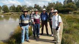
Featured image – Guys on Greenways Track 3 in front of a pond
I led this walk with 5 walking. 4 met at the Shed by 8.30am & drove to Weeroona Dr, Wamboin where we met 1 more. It was -5C that morning with a lot of frost around and it only got up to 9C in the middle of the day. Most of the walk was at an altitude of about 800m with some variations up to 870m as we walked around in a circuit. The weather was fine with light winds and was mostly sunny.
From about 9.20AM we walked clockwise along Track 3, then we took the trail to Majors Close, Track 5, along Weeroona Dr, then along Track 6 to Norton Drive where we stopped for a break. The early sections were the best part of this walk. The remainder was on country roads both bitumen and dirt.
We then headed south along Norton Rd, until we could turn left onto Ryans Rd which we took us through to Wirreanda Rd. The latter turned out to be a very long dirt road with a couple of small hills to go over & with some grand open views on its western side. It was nice walking as we met no traffic at all on this section. We passed a winery along this road which was on the Norton Road side but backed onto Wirreanda Rd. I believe this was The Contentious Character Winery at 810 Norton Rd. We reached our cars around 12.48PM. As it was late for a couple of the guys we drove straight home to the Belconnen area of Canberra and were home around 1.45PM.
Overall a Medium walk of 12.7km, taking around 3hrs 28m including breaks.
Walkers: Bob Salmond, David Leach, Drew McDonald, Neville Viney, Greg Hutchison
Drivers: Drew McDonald, Neville Viney
Map of walk | More pictures in Google Photos | files including gps located in Google Drive
Notes re Map: GPS Map Views provided using Garmin Mapsource on an Oztopo Map Base with permission of © BKK Enterprises Pty Ltd, http://www.gpsoz.com.au | The area of the walk is covered by the NSW 1:25,000 topo maps SUTTON and BUNGENDORE. As it straddles the bottom of the first mentioned and the top of the second mentioned it slightly awkward. Using Oziexplorer and an add on called MapMerge, makes it possible to merge the two maps together for at least a viewing as a digital version. You can run Oziexplorer on a tablet using the merged maps.
Information about the Greenways and walks around Bywong and Wamboin are available on the Bywong Community Site. Also I have special writeup on the Kowen Trail Runs on my site called Kowen Trail Runs. These trail runs are shown on the Bywong-Wamboin website at page. They are a series of community created paths in an area of Crown Forest just south of Bingley Drive, Wamboin and adjacent to Kowen Forest, ACT on its southern side. These trail runs can be walked as per the Greenways. The communities and the local council intentions (i.e. Queanbeyan Palerang Regional Council – QPRC) are to include the Trail Runs within the concepts of the Greenways and they have nominally called the Trail Runs Greenways No15 in their plans.