2020 07 23 Mt Majura via Majura Stone Wall & Little Majura with MelbaShed
This was a 7.9Km walk from a Car Park on the edge of Hackett, Canberra on Antill St to Mt Majura taking a route past the Majura Stone Wall and a hill called Little Majura . This was Melba Shed walk No 234 on 23rd July 2020. This is the easiest and nicest way to ascend Mt Majura which overlooks North Canberra to the west and Canberra Airport to the east.
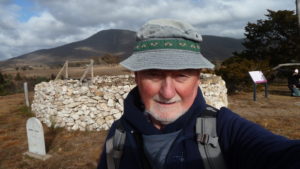
Featured image – Greg on Mt Majura Trig Point
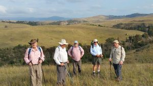
7 walked. 5 met at the Shed and drove to Antill St car park where we met 2 more. When we met at Melba it was clear but when we got to Hackett it was slightly foggy. It was -3C that morning.
From just after 9AM we headed straight up along a trail to eventually reach the Majura Horse Trail (Jn263). We then headed north along this trail in dark & dismal weather which turned out to be heavy fog over the whole mountain. Eventually we came to another junction (Jn283) where we turned east & climbed slightly on the Mawson Majura Trail for around 350m to where we could leave the trail (Jn288).
We then took an unofficial footpad up under a small powerline for around 150m before turning right & climbing along a vague footpad for around 60m where we came across the northern end of the Majura stone wall built into a fence line using an old post & rail construction with natural stones used as it base and support. We followed this up over 240m in a southerly direction before it stopped & we could rest.

We then went uphill over open woodland in a SE & south direction to reach the top of Little Majura which is well covered with Kurrajong trees & Black Cypress pines (Callitris endlicheri). We didn’t pause here but continued along its top & an east route down to the bitumen road that climbs up to the east of the mountain for maintenance vehicles. After doing 30m or so on the road we headed right & walked up an open ridge also well populated with cypress & kurrajongs. Then we made the top & could vaguely see the radar station working through the cold mist. We stopped on the top for a second break but had little to see.
We headed down the main ascent trail & stopped again at the Sheep Camp Station which is the junction of the main trail & trails to the east & west. We continued then down passing several groups of young workers trying hard to smash rocks & improve the condition of the track. We headed straight down & went across several lower tracks to reach the Hackett fenceline. We then took a vague footpad along the fencline until we connected with the trail up we started on at a junction near Gate 16 on the map. We reached the cars at 12Noon.
Overall a Medium-Hard walk of 7.9km, taking around 2hrs 58m including breaks.
Walkers: Bob Salmond, Drew McDonald, Neville Viney, John Marsh, Steve Mawer, Tony Weir, Greg Hutchison
Drivers: Drew McDonald, Neville Viney, John Marsh, Greg Hutchison
Map of walk | More pictures in Google Photos | files including gps located in Google Drive
Notes re Map: GPS map views on map base using open source Open Street Maps (OSM) NSW Garmin map using Garmin Basecamp | The area of the walk is covered by the NSW 1:25,000 topo map CANBERRA. Most of the walking tracks and footpads around the Majura-Ainslie areas are not well shown on the topographic maps. One is better served looking at Open Street Maps (OSM), Click on Browse Map of Canberra, then zoom in to Majura and Ainslie area, and using the selectors on the right choose the Cycles Layer. I think you get a better view of tracks than the Standard Layer. For more information on Ainslie and Majura Mountain tracks see my blog post