
2020 06 11 Umbagong Ginninderra Ck Dunlop Grasslands Goodwin Hill with MelbaShed
This was a 14.6Km walk from a Car Park on the edge of Umbagong District Park in West Belconnen, Canberra to the nearby Stepping Stones across Ginninderra Ck, then out to Dunlop to view ponds and old settler sites in Dunlop Grasslands Nature Reserve. This was Melba Shed walk No 231 on 11th June 2020.
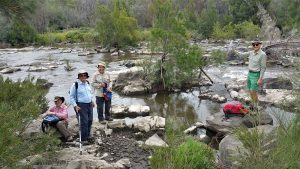
Featured image – Greg in Dunlop Grasslands Nature Reserve
I led this walk with 5 walking. 4 met at Melba Shed by 8.30AM & drove in one car to Florey Drive, Latham where we met 1 more.
Then from 8.50AM in very heavy cold fog we headed down along nice trails to the Stepping Stones over Ginninderra Ck.
Then we headed back and up to a kids playground then along easy dirt tracks to join the main path along the Creek under the bridge on Florey Drive as it crossed the Creek. Then we walked along the north bank of the Creek admiring some wooden craft at a playground & some ducks in trees, passing Jaramlee Pond & then turning north near Fassifern Pond & continuing along a fenceline to the Fassifern property until we reached the West Belconnen Pond in West Dunlop.
We then headed west around the pond & followed a path north along the west edge of Dunlop in Dunlop Grasslands Nature Reserve. Here we had to climb a couple of gates that were locked which made little sense.

We continued right up to the northern boundary & then turned east along the boundary until we reached an Osage Orange Tree. From here we turned back a little & headed south to reach the site of the Charnwood Homestead. There is not much to see although we could see some olive trees. The site is degraded due to local kids using it as a mini mountain bike area.
We went over & read the Canberra Tracks information sign & then headed west to soon reach the Crowajingalong Site sign. We tried to find any easy way to get over the fence but failed so we didn’t visit the site. Then we headed south west to then climb over another locked gate and then went west & south west to then have to climb another gate before we could walk down a long easy path.
We followed it all of 2km under the powerlines until we crossed under Ginninderra Drive, & then in another 400m we turned left along Archdall St, before winding up a little to reach Goodwin Hill Reserve.
We then traversed along the ridge until we reached Beeston St & continued down Hancock Cr to reach Florey Drive & then the cars at 1.03PM.
As we drove home the weather cleared as the sun came out for a short time. Due to the heavy fog & wet ground from some light rain the night before some of us ended with wet feet & wet lower parts of our trousers. Later the fog returned for a cold bleak evening.
Medium walk, of 14.6km, taking around 4hrs 12mins.
Walkers: Bob Salmond, Drew McDonald, Harry Angel, Neville Viney, Greg Hutchison
Drivers: Bob Salmond, Harry Angel
Map of walk | More pictures in Google Photos | files including gps located in Google Drive
Notes re Map: GPS map views on map base using open source Open Street Maps (OSM) NSW Garmin map using Garmin Basecamp | The area of the walk is covered by the NSW 1:25,000 topo map HALL


Excellent pieces. Keep posting such kind of
info on your blog. Im гeally imрressed by yоur ƅlog.
Hey there, You havе done an incredible job.
I will certainly digɡ it and individually recommend to my friends.
I’m sure they’ll Ƅe benefited from this site.