2020 02 27 Kowen Forest Trails with MelbaShed
This was a 9.7 Km walk around part of Kowen Forest trails adjoining the NSW border and taking around 3.5 hrs. We also walked through some local trails within a crown forest reserve in south Wamboin that borders the ACT but within NSW. This was Melba Shed walk No 226 on 27th Feb 2020.
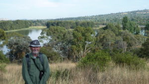
Featured image – Greg with wrecked car in Kowen near Poppet Hill
I led this walk with 4 walking. 3 of us met at the Shed by 8.00AM & drove to the car park on Bingley Way, Wamboin. Here we met one more. We drove via Gungahlin, Horse Park Drive, Mulligans Flat Rd, East Tallagandra Lane, Sutton Rd and past Sutton Village to the Sutton turnoff, taking Sutton Road south towards Qbn, then after 8.8Km taking Norton road east for 4.2Km, turning then right or south on Bingley Way, then driving 2.4Km to the parking location which is opposite 241 Bingley Way, Wamboin.


Then from 09.00AM we walked up the dirt Crown Rd, taking the Border Track through to the border and walked a circular route around part of Kowen Forest similar to what we did on walk 186 of 19 Jul 2018. In one spot we climb steeply up a rough track created by trails bikes. Near Poppet Hill we found a wrecked Ford Fairlane abandoned near the border trail. The highest point we got to was Poppet Hill at 921m, with the lowest at the Pond around 785m & 850m where we parked the cars.
From Poppet Hill we could see out over Queanbeyan to Hume and south west over south Canberra and as far west as Black Mountain.
We then returned to the cars at 12.30PM. The weather was warm & fine & mostly cloudy.
It was an Medium walk of 9.7 Km taking 3hrs 30m incl breaks.
Walkers: Drew McDonald, Harry Angel, Neville Viney, Greg Hutchison
Drivers: Harry Angel, Drew McDonald
Map of walk | More pictures in Google Photos | files including gps located in Google Drive
Notes re Map: GPS map views provided using Garmin Basecamp with map base from OSM an open source service | The area of the walk is covered by the NSW 1:25,000 topo map BUNGENDORE