2019 06 24 Majura Dams & Mt Ainslie Recce Walk
8.7Km walk taking 2hrs 50 mins checking out feasibility of an interesting walk between the Majura Dams and the ridgeline between Mt Majura and Mt Ainslie mixed with a mountain bike track between Hackett Car park and the Majura Dams, in Canberra, Australia
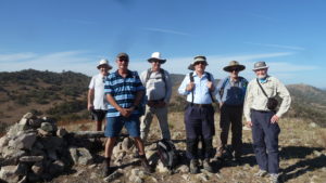
Featured image is of Greg on the Rideway along the Old TSR Track overlooking Canberra Airport
This was a reconnaissance (i.e. a recce) walk around parts of both Mt Majura and Mt Ainslie Nature Reserves in the northern suburbs of Canberra. I did this to validate my route and thoughts on a planned walk for Melba Shed. As it turned out I think the walk is slightly harder than I remembered from past walks, although not really technically difficult.
The day was cool with a slight breeze blowing. It was now winter with zero or below mornings. So I wore winter clothes with a polar fleece top covering and a woollen beanie.
I parked at a usual car parking spot in Kellaway St, Hackett. I then headed up a management trail called Hancocks Road or Trail. Its a main link route up to the top of a saddle that sits between Majura and Ainslie peaks. Initially I only went up it some 400m to point J2 (ie Junction 2) whence I turned north along a well used Mountain Bike Trail for about 1.1km. This was a nice walk along a well hidden path through a semi open eucalyptus woodland crossing many side tracks to point J217.
The totality of Majura-Ainslie is criss-crossed by numerous trails and pads and hence an awful lot of junctions and thus gps’d points.
From J217 I walked east up the Blue Metal Road for about 200m to another junction where there is a display with information about the area with a map. I took the left side trail and was soon at the Lower Majura Dam which has a sign explaining its purpose and future. I then went around the dam to the north and took a central foot trail east for another 200m to the Upper Majura Dam. This time I stayed on its north side and continued east along a well used foot trail for 300m until J246 where I turned South-east over a vague foot pad to reach the Blue Metal Trail again. I then continued on it to the fence and gate between the reserve and the Majura Pines Mountain Bike area.
I then turned south and took a foot pad south to south-west past some large water tanks and along the fence line between the reserve and farmland to the east in the Majura Valley.
I then continued along this well formed management trail for 1.7Km, the Old TSR Track stopping to view the Majura Valley and also the Canberra Airport that can be seen to the South East, before finishing with a short detour on a short footpad to reach the saddle on the Hancocks Road mentioned earlier at point J6. I could have then taken one of several routes but decided to cross the road and join another path that runs down parallel to the Hancocks Rd but south of the powerline.
In this area I entered a drooping she-oak or drooping sheoak forest (allocasuarina verticillata) which is fairly common around the tops of Mt Ainslie & Majura. Then at J12 I turned south on another path up through the forest to reach the Old Tip to Summit road before reaching the Five Ways which is point just north of Mt Ainslie where 5 paths meet. I took a path that is part of the CCT that runs up along the western edge of Mt Ainslie just below the main bitumen summit road. Then at J20 I took a rough foot pad down to meet another path around the mountain at J19. The initial drop was very steep and I had to hold onto sheoak stems to avoid slipping or falling. Turning right at the bottom its was a nice easy beautiful path through the sheoak forest until I met the path down from the 5 Ways at J18. I then went down that path to meet the Western Powerline Road (West 132KVA Track) at J16. I then travelled north on the road for 200m until I was at the junction, J13 with the Old Tip Summit Rd. Here I turned left for a few metres before heading out to the right a little to follow an old partially indistinct footpad across to the car park where I had started. This last leg is a good shortcut through fairly open and a slightly degraded woodland
It was an interesting, relatively easy walk of 8.7Km taking around 2hrs 50mins
The route was mostly on rough bushland dirt paths with some climbing on trails and foot pads, some open woodland country, some rocky country and roads suitable for most, except children and the aged or those with disabilities. It could be used by the youngsters an oldies by taking out the hilly bits. There were no facilities nor any water available.
Map of the walk | More pictures in Google Photos | files including gps located in Google Drive
Notes: GPS map view using Mapsource on a map base using OSM NSW Garmin Cycling Map | The area of the walk is covered by the NSW 1:25,000 topo map CANBERRA. However there has been so much development in the area not all the area is shown as developed on the current version of the map. Thus for practical purposes Open Street maps are better for planning walks in this area as they show the foot tracks much better. For my notes on Mt Majura and Ainslie