2019 01 15 Black Mountain Walk
Short walk up and around Black Mountain in Canberra Australia to help David get fit for a future large walk as well as to check out names of some of the trails.
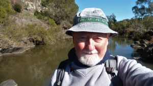
Featured image is the author, Greg on Black Mountain
Black Mountain stands out in Canberra as one of the large hills that surrounds the centre of the City as well has including a Telstra communication tower that services central Canberra with radio and TV transmitters as well as lots of microwave dishes for various short and long range communication links. The tower sits in a reserve which provides numerous opportunities for walking and even cycling as well as picnicking. It has numerous tracks that climb from its base to its top, thus making it suitable for runners and walkers to try and get fit as well as enjoy some great views.
On this occasion David R from Melba Shed wished to see how he went at climbing up one of its trails in preparation for walking the Laparinta Trail near Alice Springs. As the forecast for the day was a max of 39degC we decided to meet early at 7AM and drive to a spot along Belconnen Drive from which we could quickly start our walk.
So at just after 7.15AM we started walking heading along footpads and then formal management trails until we started to climb up a popular ascent trail which we will shall call the Link Trail. It eventually joined the Summit Trail that takes walkers from near a rear gate to the Botanic Gardens up to the Forest Trail around the top and ultimately up a concrete path and then around and to the top.

This we followed until we reached the top. Unfortunately David’s fitness was still not 100% percent and he felt the climb so we decided to continue around the top and return to the car. So we headed down a trail from near the tower that took us straight down to rejoin the Forest Trail as it cuts across the road up to the tower. This part of the Forest Trail is quite nice and afforded us views over the lake down to Woden, the aboretum, west to the Brindabellas and over Belconnen Town Centre. As we returned to where we had climbed up we went back down but took a side track that led us to the junction of the Little Black Mountain, Kids Lookout Trail and the Black Mountain Trail. We went down the Little Black Mountain trail a short distance before taking a footpad to the west that then conveyed us over the Summit & Callitris trails and through the bush until we reached the Old Weetangera Road where the natural continuation north of the Road had been closed by a project that closed unofficial MTB trails. So we walked through the bush that was quite easy and fairly open until we reached the Link Trail again and close by we could follow a footpad back to the car.
We started at 7.18AM and finished at 9.08AM, having thus walked 5.4Km in 1 hr 50 mins have climbed from 640m at the car up to 812m at the top of the mountain.
Map of walk | Pictures in Google Photos | Google Earth GPS file
Notes: The GPS map view was provided on a map base using maps created using Open Street Map open source product | gps, gpx, GE & jpg map files are all located in Google Drive