
2018 09 13 One Tree Hill with MelbaShed
This was a walk I led from Hall village on the edge of Canberra up along the Canberra Centennial Trail (CCT) to One Tree Hill. The weather was a superb spring day along a nice track with only a few others and with fantastic views over north Canberra and parts of NSW out west towards Murrumbateman. This was a Melba Shed walk
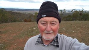
Featured image is of Greg on One Tree Hill Lookout
I led this walk with 6 of us walking.
6 of us met at the Shed by 8AM and then drove to Hoskins St, Hall next to the Primary school site. Then we walked up the road and along the CCT to One Tree Hill. We stopped along the way for a breather & to take in the views across Gungahlin & especially the new suburb of Taylor being setup.
We then took the track to the top where we had an extended stay & took in views across to parts of NSW to the west & over North Canberra, Gungahlin & Belconnen to the east & south. Note there are around 179 wooden framed steps that are dug into the hill near the summit. Also there are no toilet facilities at One Tree Hill nor any water. There is a nice seat there where you can sit and observe the scenery over Gungahlin and parts of Canberra.

We then returned the same way to the cars. On the trip there were a lot of pink plum tree flowers showing in Hall & lots of yellow wattle along the track.
We started at 8.25AM and finished at 11.23PM, ie about 3hrs overall. The trip was 8.7Km, Medium quality walk all on trails, however there was a short steep climb from CCT up to the hill top. Overall we started at Hall at altitude 650m and reached a peak of 876m on One Tree Hill, ie overall climb of 226m.
NSW Hills: From One Tree Hill, 876m we could easily see Mt Spring, 889m on bearing 340mag, Anchow Hill, 775m ~330mag, Doonan Hills, 722m ~320mag & Bedulluck Hill, 700m ~310mag.
At the finish we had coffee & milkshake at the Daughters of Hall Cafe in Hall just around the corner from our parking spot. Its a nice friendly spot with a varierty of drinks and food.
Walkers: Bob Salmond, Colin Fitz, John Edge, Paul Taylor, Neville Viney, Greg Hutchison Drivers: Bob Salmond, Fitz
Map of walk | More pictures in Google Photos | Google Earth GPS file
Notes: GPS map view created using Garmin’s Basecamp using Oztopo Map with permission of © BKK Enterprises Pty Ltd, http://www.gpsoz.com.au | gps, gpx and GE files are located in Google Drive


I did the walk today, 26 June 2019, and counted 179 wooden framed steps that were dug into the hill near the summit. I think the walk would be better when blossoms and wild flowers are out. I started out at 3.00 pm which was a little late as it was nearly dark when I returned. It pays to know that there are no toilets in the near vicinity.
Hi. Nice to see you made it. Yes heading out at 3PM is quite late in winter. Actually thinking about it there are few peaks with toilets. Most of them around to have to go au natural. eg Mt Majura, Ainslie, Taylor. Black Ntn has a toilet inside the tower you can use