
2017 10 19 Red Hill Mt Mugga with MelbaShed
I led this walk, with 7 of us walking to Red Hill NR and along some of the Canberra Centennial Trail to Mt Mugga Mugga & back to Red Hill via the Stone Circle & Davidson trig
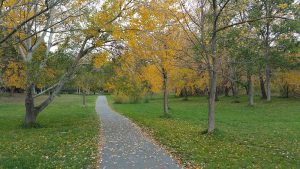
Featured image shows Stone Circle of southern end of Red Hill NR

7 walked. 5 of us met at the Shed by 8.00AM & then drove to the parking spot at Red Hill lookout near the Restaurant, where we met 2 more. Then from 8.50AM we walked south along CCT to a saddle then followed CCT down towards Mugga Way, turning right just after a fence & followed footpads along trench pad all way & parallel to Mugga Way until we were close to Hindmarsh Drive, then we dropped down to the fenceline, crossing Tamar St, then followed a track parallel to Hindmarsh drive until we met Dalrymple St, turning right & crossing Hindmarsh Drive at the lights. Then we followed CCT along new alignment right around Mt Mugga to close to O’Malley. On the way we passed the new Dhulwa Mental Health Facility which has an amazingly unclimbable high wire fence for such a facility. Just as the track descended to a gate next to Hindmarsh drive 3 of the group decided to return early & crossed Hindmarsh Drive & took the track down to Garran & followed a boundary trail north until they could turn east at a saddle & then climb back to Red Hill. The four remaining walkers continued past Mt Mugga quarry to near O’Malley & then took a short cut back to Hindmarsh drive & carefully crossed it before then following a track west until next to the Garran houses then followed a footpad up to the Stone Circle, thence on to Davidson Trig Trail & along the ridge back to Red Hill where we met the others at the cafe at 12.05PM. We had coffee & some cake at the Little Brother Cafe to celebrate the walk & Greg’s belated 70th birthday from Sept.
Views. These were some good views over Central & North Canberra and down to the airport as well as over Woden and out to the Brindabellas.
The walk was Medium-Hard, distance was 11.4Km, mostly on dirt management trails & some grass tracks, with a couple of small hills to climb. We took around 31/4 hrs. 3 of the team only did about 9.2Km

Walkers: Bob Salmond, Brian Taylor, Drew McDonald, Colin Fitzpatrick, Tony Danaro, Wally Kulesza, Greg Hutchison
Drivers: Colin Fitzpatrick, Tony Danaro, Greg Hutchison, Drew McDonald
Map of walk | More pictures in Google Photos | Google Earth GPS file
Notes: GPS map view on map base using OSM | gps, gpx and GE files are located in Google Drive


Hi Greg fascinated by your walk just found your blog can you tell me exactly where the stone circle is and how did you get across Hindmarsh Drive?
Best wishes to you Lucinda
Hi Lucinda. Have a look at the Map link which shows you where we crossed Hindmarsh Drive. Best spots are way wast at corner of Mugga Way and Hindmarsh, or way west down the hill near edge of the reserve. We crossed closer to the top of the rise on Hindmarsh and carefully raced across Hindmarsh. There is a dividing space in the middle of the road so you only have to watch one way crossing each section. As to location of the circle, assuming its still there, also see the map which clearly has a point marked as Stone Circle. Its about 150m SSE from Astley Place, Garran. It down hill to the west from the main north south path along the ridge about 120m. You can also see a small dark oblong circle if you look on Google Maps and switch to satellite view. GPS from Google is about
35°20’30.4″S 149°06’58.2″E OR -35.341775, 149.116158
Hope that helps