2017 04 13 Black Mtn ANBG Bushland Nature Walk
This was a reconnaissance walk around part of Black Mountain linking up with the Australian National Botanic Gardens’ (ANBG) new Bushland Nature Walk to create a circular walk. My journey was some 8.7km which entailed checking several track options to ensure a viable and sensible future walk that offered great views, sensible climbing and a little excitement tinged with a walk back through the ANBG and sampling the fare at their cafe.
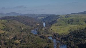
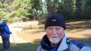
Featured image is ANBG Bushland Trail Viewing Platform with Lake Burley Griffin in the background.
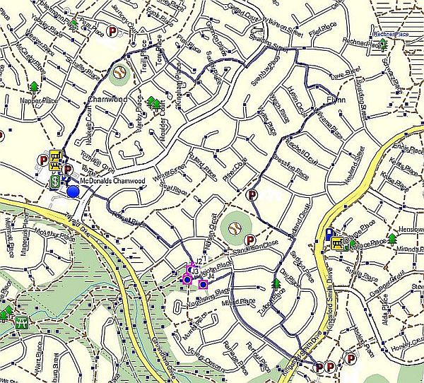
I started out at 9.47AM from a small car park behind the ACTEWAGL major sub-station on Frith Road, Black Mountain. From there it was a small trudge along a dirt firetrail past the entry to the ANBG which links to the summit trail up to the top of Black Mountain. However I went past this and along the “Bot Gardens Trail” which runs parallel to the western fenceline of the ANBG.
On reaching its junction with the Black Mountain main public access road, I crossed the road and adjacent to the location of an ICON Water main water tank went through another gate and down an old trail which I had never used before. It was initially quite steep but flattened out before it nearly joined the new ANBG Bushland Nature Walk. The new trail had interfered with the old path junction but the path I was on can be used to either turn right to join the new path quickly or left (ie east) to join the new path in 100m or so. I found the new path quite easy to walk on being a nice gradient and with several bridges over gullies. Along its route were explanation signs about the area and particular shrubs and trees. The official path finished in a viewing platform with great views out over Lake Burley Griffin to Parliament House, the National Library, High Court and Questacon as well as Russell and parts of Civic. The only spoiling factor was the constant noise of traffic below on Parkes Way.

Just past the Platform the trail continues but eventually narrows and becomes more rugged. However I did not take that path as yet but turned uphill under a power line on a faint but obvious and very rocky footpad that took me up to the main Black Mountain Road. This footpad initially was very steep but flattened out a bit as I approached the road.
On reaching the road I had to walk up along it which is tricky as there was little of any edge. However in around 150m I came upon a special sort of a siding where one could park the car as well as a gate that led down to the Lake View Trail that goes right down to valley below. However I crossed the road instead and followed a well defined path up until I came across a bitumen path quite close to a built lookout with a seat. Point “Seat&Lkt4” on the map and gps file. I continued past this point and followed a narrow dirt pad past similar lookout spots until I reached the first such spot Point “Seat&Lkt”. Near here there is a track that goes down to the path I had come from initially, the Bot Gardens Trail. My thoughts were that it would make sense to come up this latter trail and take the route I had walked back down to the Lake View Trail. This I did. However on the way I took a picture from “Seat&Lkt2” which I think offered the best views over the lake and Canberra city from this area.
I continued back down to the Lake View Trail past the gate near the main road. Then I deviated off on some side trails to the east. I think that is not productive as most of these lead nowhere.

After rejoining the Lake View Trail, I then walked down for around 225m, then turned hard left and took a small path along the steep side of the southern face of Black Mountain. To me this was the most exciting part of the walk as one is walking through some dense pieces of bush mixed with some quite scary pieces where you can look down and see cars below you on Parkes Way. There are no barriers and the trail is slightly slippery and steep in places. However there are enough trees below to break a fall so there is no need to panic. The views make up for any unease with grand scenes over Western Park and the Black Mountain Pensinsular below. Eventually the trail rejoins the ANBG Bushland Nature Walk and I then continued on to the bottom, across the main road and into the ANBG proper for a Mango Smoothie at the cafe. It was fairly busy being school holidays and the day before Good Friday.
Note that the gate is only unlocked between 9AM and 5PM and the gate at the top for the Black Mountain Summit walk only opened between 9.30AM and 4.30PM according to the signs on the gates.
I finished back at the car at 12.38PM.
It was interesting that I meet no one on the walk except for some local lunchtime walkers behind the ANBG. For the new walk along the edge of the lake I had meet no persons which indicated that the ANBG was not advertising the new bushland walk very well
Pictures on Google Photos | GPS and Google Earth files on Google Drive