Kosciuszko National Park – Gungarlin Kidmans Hut Great Divide – Jagungal Area 15-18 Oct 2022
This was a 4 days 37Km medium-hard walk from the Snowy Plains at the Gungarlin River North Bridge to Kidmans Hut, then up to the Great Dividing Range and return. The trip was to get to Mawsons Hut and recheck some of my previous gps route data as well as to get out of civilisation and detox.
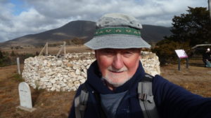
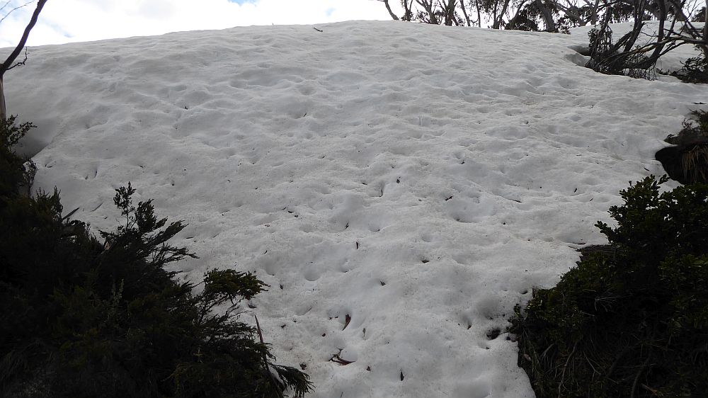
The featured image is a view of a steep snow bank at the top of the trail just below the plateau below the Brassey Range
Introduction
This was a 4 days and 36.7 Km medium-hard walk from the Snowy Plains at the Gungarlin River Crossing near Nimmo Hill to Kidmans Hut, then up through the Burrungubugge River gorge to near the Great Dividing Range return.
On the morning of the 15th Oct 2022, I set off from Canberra and headed to the Gungarlin River to walk across a small section of Jardine’s property, and then down upper Teddys Ck area of Snowy Plains to Kidman’s Hut, thence up an old bridle trail route to the Great Divide just north of Big Brassy, and back to Kidmans. Originally this was planned as a 5 days trip maybe going to Mawsons Hut, etc.
My pictures of this trip are available on Google Photos.
Note: Waypoint/Points mentioned in this document refer to waypoints in the GPX file as well as shown on the trip maps. The waypoint naming and numbering was relabelled a year ago to make it consistent and include many cairns along the way. I have to include some more new points after using an old route from North Gungarlin.
Warning & Dangers
The area mentioned in this post is largely rugged and partly untamed. Yes it was grazed in the Stockmans’ Days and many walkers have negotiated the area since. There is substantial bush to be negotiated and some large trees to be wary off. The area was heavily burnt in the 2003 fires and has recovered with a vengeance i.e. the scrub in 2022 is sometimes more dense than what was there in 2002. The climb from the Gungahlin Valley at the junction of Teddy’s Ck and Collins Ck is not difficult but the track negotiates an area bordered with extremely large and tall gum trees, probably alpine ash, all of which were heavily burnt in 2003 and many large trees have fallen, some across the track, although now mostly cleared. There is no formal track past the Little Brassy Gap (also shown as Brassy gap on some maps) which is the location where you would pass through the Little Brassy Range and then head down to Kidmans Hut. This gap is often covered in snow in winter up to October. Mobile phone coverage is limited with Brassy Gap and parts of the Great Divide (Including up behind Tin hut & maybe the Mailbox) being the only spots where coverage is guaranteed. The altitudes are also high for Australian walks with the Gungarlin Valley, around 1,300-1,400m (and can be snow covered in winter), 1,620m at Little Brassy Gap, 1,515m Kidmans Hut, 1,855m crossing through the gap north of the Brassy Mountains, 1,810m at Mawson’s Hut, 1,860m at Tin Hut, Gungartan Pass 2,000m, Mt Jagungal 2061m.
Day 1 – Sat 15th Oct
I left Canberra around 6.35AM and drove to Cooma where I had coffee and some breakfast at Maccas. I then drove via Rocky Plains down to the Nimmo Bridge crossing of the Eucumbene River, then up to Nimmo Hill and then down to the Gungarlin River northern bridge crossing. The section from Eucumbene Road to Nimmo Hill was quite rough in places with many large ruts across the road caused by recent heavy rain.
The last section down from Nimmo Hill to the river was quite bad with several very muddy sections and spots where a car could be easily damaged by grounding. Sections each side of a small bridge were very rough. I parked my car on grass just above the main track at GPS 55 H 640278 5993130, which was overlooking the bridge and crossing. The Bridge and the next paddock to the west are a Travelling Stock Reserve (TSR). I believe you should not camp there but it’s probably OK to park there as long as you do not block access. You should be aware that a lot of cattle are brought into the valley and out of it every year on trucks. Check out https://www.lls.nsw.gov.au/help-and-advice/growing,-grazing-and-land/travelling-stock-reserves/using-tsrs.
I then started the walk quite late around 10.37AM, walking initially along the dirt road known as the Snowy Plains Fire Trail that goes west right up to the KNP Boundary. The last section after Bulls Peak Ck is not advisable unless you have a 4WD or good SUV. I have crossed the creek in a Subaru Forester but I wouldn’t have done it on this trip as all the streams were much higher than normal, and it was also the time for the snow melt to occur. I continued walking on the trail through a gate where there is a sign Private Property No Through Road or similar. This is nominally true but I believe you can walk along the road right up to KNP near Cesjacks. Through the gate the owner Tim Jardine has for some reason taken down fences on both sides, however there will still be a public ROW covering the road section and several metres each side of it.
However, I soon turned left or notionally west and headed up a valley stopping only to visit a Weather Station that has been there for many years. It’s at 55 H 639165 5993537. I then continued westerly, crossed a wide creek and had to climb up a hill before I could reach the boundary fence with KNP. The best place to cross the fence is 100m further south than I did, as the fence passes a large rock and I could have easily squeezed through a gap. Near here in KNP there is a nice flat partly shaded area that would make a nice camping spot. Water can be found further along to the west but may not be easily obtained if it’s a dry season.
I then travelled generally SW along the route of a recut fire trail (FT) probably from the 2019/20 fires. Towards its west end it was very wet and covered by water in spots. This FT also goes north to the adjacent property (The Barley Fields) as well as splitting and going south to join Teddys Creek FT near the junction of Teddys and Collins Cks. (It’s also known by the locals as The Broken Dray Trail)
Instead of following the trail north towards the Barley Fields I went across a creek and open country to pick up the FT again which took me down to Teddys Ck and Collins Ck Junction joining Teddys Ck FT which one would use if coming from the Gungarlin River Camp Ground. The FT down crossed quite a few very muddy stretches trail.
At the Ck junction I declined to jump/step across and took my boots off and waded across using thongs. It was cold and muddy and sandy. I then walked SW uphill until I reached the edge of Mill Flat. Finding a nice large log by the side of the trail I stopped for lunch.
I then went up through Mill Flat then on the old track towards Kidmans Hut. I did detour to the east to checkout an area near a swamp which might be a nice camping area with water nearby.
I reached Little Brassy Gap OK but had to trundle over several muddy and wet stretches. I have never seen it so wet.
Little Brassy Gap was the highest point on Day 1 being around 1,635m. Mobile Phone calls (Telstra & Optus at least) can be made from here. From this spot one usually gets a splendid view of the Brassy Mountains to the south-west as well as the ridge to its north to The Mailbox. The whole upper Burrungubugge River valley was also in view, although I could not see Kidman’s hut from this spot.
I then continued down the obvious track that heads down roughly south west initially over an open wet plain until it forces the walker to exit the plain through an old cutting to then cross an awkward bushy creek before continuing down the valley on its northern side. A range of cairns and the odd tag guided me most of the way. I then had to cross a very muddy creek and climbed up onto dry land before heading down through a vague track until a more definitive track could be followed down to then carefully cross another creek before the final leg to Kidmans.
This final section is mostly open although badly disturbed by wild pigs. They have created a fair track down towards a tributary of the Burrungubugge River which I crossed carefully. I then tracked a bit to the south to avoid scrub and then turned north to reach Kidmans by 4.12PM.
I then setup my tent and prepared to collect some firewood and water. I went down to the adjacent creek but couldn’t easily get close to the water due to the creek being partially in flood. I then went south a bit and then east and down and around some scrub and was able to get water off the same creek. It was much easier and safer than the normal spot closer to the Shed.
Then I saw two women heading up from the creek towards where I was camped. This was a shock being later in the day but I guess it was just a Sat. It turned out that I knew one of them.
I had previously met her several years ago at Cesjacks. She and her partner turned up late on that time also. She was Taya Fabijanic accompanied by her friend Jay Sims. It was lucky they turned up, as later on having diner I realised I had left my spoon and knife behind. Jay had a spare splayd device which worked for me as a spoon and knife.
Taya’s partner is Mika Kontiainen who is currently doing a 3 years stint in the Solomons for Australia’ s DFAT. I had walked with him in the last couple of years as we worked on reverifying the old Arsenic Ridge route between Happys Jacks/Brooks Hut and Tabletop.
On Day 1, I did about 11.7Km to Kidmans and further, and of course I had driven around 200Km as well.
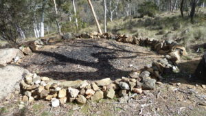
Just to make it interesting I took the girls down along the ridgeline that runs downhill from Kidmans Hut after they had set up their tents to try and find remnants of an old SMA Stream Gauging site. I had been made aware of it by Jason Baldwin, a guy I know from Canberra who had enquired of me on the best way to get to Kidmans. He is really a skier and had had issues trying to get to Kidmans from the Main Range in the snow. Getting to Kidmans from the Gungarlin River he had accidently found the plinth and a metal tin down from Kidmans.
His GPS reference was close and we found the plinth and tin hole quite easily. According to information from David Scott it was a “Gauging Station 1955-60, GPS 632190 5990830”. My readings are roughly 300m south west of the site on David’s map. The site is roughly 500m south of Kidmans Hut. My readings, were:-
- Concrete Plinth Stream Gauge GPS/UTM 631897 5990732
- Concrete cover 631894 5990728
- Tin Can with Circular Cover with ladder 631895 5990724. This is the most interesting. It’s a hole in the ground, quite deep with water in the bottom lined with a circular metal container, bit like an extruded 44gallon drum. There is an old 5 rung metal ladder stuck in the top inside the container. Seems like it was placed there, upside down to stop anyone climbing into it!
The concrete plinth I assume was placed on the very large rock as it would be easy to spot and probably had a metal sign on it with a SMA ID and label. I assume the label had been taken away or wore off. I have seen several old SMA trig ID plates around and I remember we found two trig markers when we recc’d the Arsenic Ridge Trail. I am unsure, but directly below the tin can it looked like a smooth rock was across the river. Was it an old concrete barrier. Too hard to tell as the river was running very high but it sure looked like something had been across it. It was now very smooth and looked just like a rock. It certainly was not a small concrete barrier like can be seen on Back Flat Creek between Valentine Falls and Grey Mare Hut.
During diner Taya told me that her husband, Mika had been to Kidmans a week or so ago with one of his sons and had found it too dangerous trying to cross Valentine Ck as the water level was over waist deep and there was a large snow bank on its west side further making a crossing dangerous. They had not crossed and instead camped a night at The Mailbox.
Kidman’s Hut GPS 631845 5991223, altitude 1515m. It’s a corrugated iron original stockmen’s hut built about 1932 by Ken and Alec Kidman & Bill Napthali. It’s a single room, 3.6 x 3m unlined, fireplace, with a stone floor. The corrugated galvanised iron was fixed to nogged timber frame. It has a wooden board door, with no window. The fireplace with timber frame, galvanised iron cladding and rock lining. The fireplace was rebuilt by NPWS tradesmen in 2007. According to Robert Green the floor was covered in stones after the fireplace was rebuilt by Ian Frakes and hut maintainer Ian Macaulay around 2008. (Data mostly from David Scott)
Day 2 – Sun 16th Oct
I arose late around 7.30AM to a cold morning.
I then decided to walk up the route to the top of the range and check out the current status of the route. The girls took their time as they were simply returning to their car and Canberra.
I was very late and left Kidmans about 10.37AM.
I followed the old historic bridle trail route up from Kidmans, although the first section is a steep climb up a small recut section until I reached the small plain above. I then passed a large cairn on a rock, now labelled K052 Cairn, crossed a small low scrubby section before I could see another small cut section from also now labelled K053 Rte Up. This spot marked where I could follow a footpad up to a higher open area next to a Cairn now labelled Cairn 2. From there I went south west down to marker WP K058 M01 (M for Mika) which then allowed me to get easily to another Cairn now K060 Cairn. I then headed across the valley with a creek to cross now WP K062 Ck before heading slightly uphill past point WP K063 then point K064. Along this last section there was a lot of thick woody low-level scrub which had to be walked around before I reached the point now WP K065 Bottom Burrung Gorge. I was now in the real Burrungubugge Gorge which I knew fairly well and would take up to the McDonald diggings and a large open plain above its top.
I initially went to WP now K066.
I had previously relabelled all waypoints in the form Knnn starting from the Gungarlin River as K001 and reaching K045 on the creek just before Kidmans and I then restarted points at K050 just above Kidmans. Some waypoints have these designations plus a Cairn number mostly of the form Knnn Cnn if a Cairn was involved.
From here I was able to follow all the points up to the top of Burrungubugge Gorge at WP K088 C26 Top. To get there I had to cross some snow just below the top. I then traversed across the tops which was easy but very uneven and slightly scrubby to the north-west side of the River. The stone piles seen on the south side are the McDonald Diggings GPS 630416 5991396.
The river was flowing strongly and was a lot deeper than usual which was to be expected. I had previously found a spot where I could step across the river and I continued upstream across grass lumps and quite wet spots but found and crossed the river at WP Crossed River in Flood OK.
I then went up across a large open field using a feint footpad towards the next ridgeline that had to be climbed. I reached point WP K092 Jn for Alpine where in the past I had turned to traverse the small valley in that direction before it goes over a crest and heads towards the old lost Alpine Hut site. I stopped for lunch here.
I then headed up a lightly scrub covered ridge to reach an area that stockmen used to camp and rest their stock before taking the final climb up to the Great Dividing Range.
I then headed south to pick up point WP K097 C32 Tk Bottom on a rock that represents the spot where the old Bridle Trail turned slightly south to then go up a ridge to the next level of the river valley, a large open bowl below the Mailbox and its southern ridge that is the start of the Burrungubugge River.
Near this Cairn there is an old historic Cattleman’s fireplace GPS 629902 5991094 but is largely covered with scrub so I did not check it out.
I then headed up the first section for around 100m south proving easy and finding tags K99 and K100 tag correctly. There is a steep pitch uphill from K100 through to K101 up to a crest at K102 which is the top before reaching a small open spot which is a good spot to rest and check where one is at, its WP K102 Rest Spot. This section up to this spot is probably the steepest on this route.
I then headed up the route I knew but took some wrong turns and ended up being a little too far to the north side of the ridge although I made it to the top. However, I did have to go over a very steep snow drift near the top for the last 50-100m.
I made WP K130 Tk Top (Big Rock) (used to be WP151 Tk Top), which is only 50m from WP 152 Burrung R Water which is where one top branch of Burrungubugge provides easy access to clean permanent flowing water.
I had been planning to walk to The Mailbox and camp there. However, I was looking back down over a nice grassy area and decided to camp around here. I was lucky as there was a nasty breeze blowing that night and it rained later.
Today I did only 3.9km. Gosh! It felt like ten times that. I must be getting old!
Day 3 – Mon 17th Oct
I arose quite early around 7.00AM but I still didn’t get away until around 10.50AM after a wet night. I found it hard to dry everything out and slow packing the new Macpac.
I did spend some time walking around, getting a picture of Brassey Peak to the south and walking along the edge of Burrungubugge River near where it is flanked by some large snow drifts.
After starting my walk back to Kidmans I went too far i.e., about 100m east down the snow drift rather than more north easterly to pick up the trail.
I stopped fairly high up and had lunch as well as walking up and down several times to eke out the correct alignment and route of the old track. I added a few new WPs of just numerals i.e. like 214, intending to later realign previous WPs of the form K121, K125, etc. After this I continued down the way I came up from Kidmans with no issues.
I reached Kidmans around 5.20PM and set up my tent and had an uneventful evening.
Today I did 4.8km plus I did another 500m-1Km plus walking around the tops and collecting water at Kidmans.
Day 4 – Tues 18th Oct
I got up fairly early but after breaking camp, packing properly and filling out the log book I didn’t get away until around 10AM. I had an easy trip back to Little Brassey Gap and stopped at the north end of Mill Flat at the same spot I did on Day 1 around 12.35PM for lunch.
I then went down to Teddy’s Ck crossing where I intended to try an alternative crossing method. I planned to heave my pack across a nice grassy narrow 2m section and then jump across my self separately. Easy! Why hadn’t I thought of this before? I heaved the pack across just OK, then I lost balance on the recoil and my left leg and boot slid into the creek. Luckily, I scrambled out before falling in totally. Phew! Well at least one boot was dry! I then went back across to Collins Ck to get some nice water. Walking past the track crossing Teddys Ck I heard some splashing on its edge. Crikey it was a fish thrashing around in the shallow muddy edge. I got a good look at it. It was around 10-12 inch, nearly 30cm with a bundle of spots along its body. A trout no less. I had never seen a trout that big and that far up Teddys Creek from the Gungarlin River. Must be all the rain we have had. I pushed him back into deeper water with my walking pole I still had. Then I went upstream a few meters and jumped across OK.
I then headed back up Teddys Ck FT to the north and continued on this time and joined the trail coming across from Jardine’s Property. I then continued north and uphill a little until I got to the property to the north “The Barley Fields”. I then walked north east across the open fields for a bit over 2Km across some swampy ground until picking up some farm trail until I reach the Snowy Plains FT around 3.25PM. I was surprised there was no gate on the property as it joined with the FT. I then walked back along the main FT passed where I had left the FT last Sat and reached my car at 4.38PM.
Changing my clothes and packing things away I didn’t get underway until around 5PM.
Walking across or near these farm lands I did see 7 brumbies on the Barley Fields and a group of a dozen on Jardines property as well as a handful of roos.
I do not recommend walking back the way I did through the Barley Fields. It adds too many extra km to such a walk.
It was then a slow careful drive across the bridge and up the Nimmo Road. I got stuck in a couple of places but reversing slowing and continuing slowly forward worked fine. However, cleaning the car the next day, there was an awful amount of mud underneath and also stuck in the tow bar.
I reached Cooma OK and filled up with petrol and had a small snack at Maccas. I didn’t reach home until around 8.30PM.
Comments
Whilst some of the trail up to Lt Brassy Gap has been cleared, there is still substantial scrub to get through albeit the route is quite walkable. This route and old bridle trails are overall quite overgrown but that is similar all over Kosi NP and has been exacerbated by the large amounts of rain over the last couple of years.
Distances
Section / Distances per Day (km)
1. Snowy Plains FT TSR to Kidmans Hut / 11.7
1. Kidmans to Stream Gauge return / 9.2
2. Kidmans Hut to near Great Divide / 3.9
3. Great Divide to Kidmans Hut / 4.8
4. Kidmans Hut to Snowy Plains FT TSR / 15.1
Total 36.7 Km
Car Distances
The distance was around 195Km one way from Belconnen, Canberra via the Monaro Highway, Cooma to Rocky Plains, then Nimmo Rd and Snowy Plains FT. It was 183Km from home to the Nimmo turnoff along the Eucumbene Rd. Then it was about 12.0Km to The North Gungarlin River Bridge and the TSR on the other side.
GPS Files
I have from my GPS, created two GPS files that shows all GPS tracks, based on one track per day of walking plus a short track for the exploring around the Gauging Station. There is still another about 2Km of walking to get to the Great Divide proper which is not included in these files.
GPS Files are:
These show my actual walk with only those WPs created plus some older ones to show main features & sites walk
- KNP Oct 2022 Gungarlin Kidmans Range Edited.gdb. The old garmin format
- KNP Oct 2022 Gungarlin Kidmans Range Edited.gpx. The new GPS format
Relevant Topographic Maps
The topographic maps covering the area of this trip are:
1:50,000 older maps: Khancoban & Eucumbene, if you can get them.
1:25,000 newer maps:
–Nimmo Plain for Teddy’s Ck and trail, Davey’s Hut, Snowy Plains, Gungarlin River
–Jagungal for part of the Brassy Peaks & Mountains, Mailbox, Mawsons, Kidmans, Burrungubuggee River, Cesjacks Hut
I recommend that keen walkers check out the use of Oziexplorer from Des Newman’s OziExplorer plus OzRaster from GPSOz
Use of Oziexplorer with OzRaster maps for NSW enables you to load up a gpx file and see your route (and one’s available off this trip) on a modern topo map base
Diagrams, Pictures and Docs Available
GPS files, Garmin gdb/gpx files covering the trip with waypoints and various tracks are in a Google Drive folder.
Oziexplorer Maps using NSW Topoview Maps & Jagungal 1:25000 Map:-
- “1. Nth Gungarlin Bridge to Kidmans 2022.jpg” uses Mosaic NSW topo map
- “2. Kidmans to Great Divide 2022.jpg” also uses Mosaic NSW topo map
- “3. Area near Kidmans showing Stream Gauging Station Location 2022.jpg” uses NSW topo version blown up
Notes: Map view extracts came from Oziexplorer using NSW DFSI Spatial Services approval for display of their base map from Topoview 2006. GPS files available on Google Drive. One map view comes using Oziexplorer with Ozraster NSW topo map provided by BKK Enterprises Pty Ltd, http://www.gpsoz.com.au.
My pictures of this trip are available on Google Photos. The original pictures are all ~4000 x 2248, 16:9, 9.0 Megapixels, ~ 4Mbytes. The GPS map extracts are variable but around 800-1000 wide to 660-750 pixels high.
“Mt Jagungal and the Brassy Mountains” is an excellent old sketch map produced by Tim Lamble of Sydney in the late 1970’s. I have the 1st edition which I have heavily updated. There were three more editions and I also have pristine 4th Edition. I understand that Lamble will no longer produce any updates of this map so what you see is all that’s available. Some digitised versions have been made by myself and also by people with better facilities. If you need a copy contact me.
Categories: Kosciuszko NP, Mountains, Mining, Huts, NSW
Tags: Kidmans Hut, Brassy Gap, Little Brassy Gap, Snowy Plains, Gungarlin River, Gungarlin Valley, Burrungubugge River, Burrungubugge Gorge, Collins Ck, Teddys Ck, Nimmo Hill, Mill Flat, Jagungal wilderness, Snowy Plains Fire Trail,
Greg Hutchison, 5 Nov 2022