2022 06 29 Molonglo River Reserve Walk
This was a 12.8Km recce walk on a new walking route along the Molonglo River Reserve which stretches past several new suburbs in the District of Molonglo, Canberra Australia.
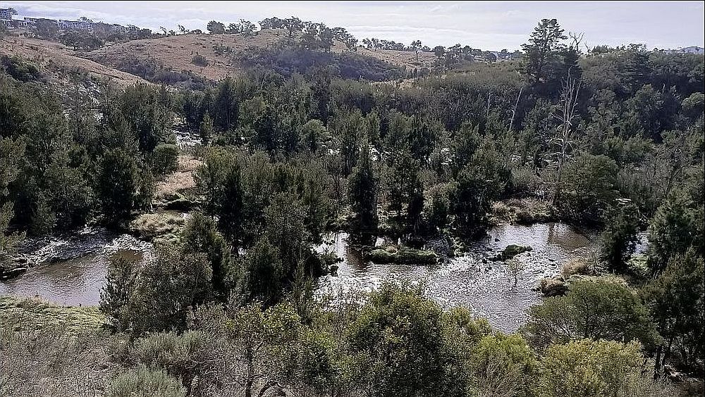
Featured image – View of Molonglo River at Misery Point
It was relatively easy going although it has some poorly thought out sections with lots of mud and soggy sections.
Access to the walk is slightly complex but does have a large parking site. I drove from Belconnen across the old Coppins Crossing then along the new John Gorton Drive, joining the Cotter Rd, then through Molonglo until I could turn left at a major junction with lights to Dargie St which then joins Kilpatrick St, the one on the left or west side. This junction and the direction is made simpler by there being an Ampol Petrol station right at the junction with a McDonalds next to it on the west side. I continued down Kilpatrick St passing the local RSPCA location on the right continuing until I was forced over a bump and had to turn left (or south) to park on a large lengthy section of old Kilpatrick St which has made a beaut full bitumen parking area. There is a major walking/cycling route that goes past the edge of this parking area providing access from Weston Creek area past this location along the Molonglo River corridor to Yarralumla and on to Canberra City. Anyone can get to the start site easily off the Tuggeranong Parkway by taking the Cotter Road exit to the west.
I walked north along the cycle path until I could turn left, or west, and cross the Western Ck small bridge, then walked back south a little through a gate and then followed the south bank of the Molonglo using a range of paths including grassy footpads, dirt management tracks, concrete walking and cycling paths and some official dirt walking tracks as well as some formal dirt sections that were the National Heritage Trail (NHT) for horses.
They have setup a couple of formal tracks, initially a Grasslands Track followed by the Woodland. I followed both of these but in the gap between I went down some grassy areas to the banks of the Molonglo opposite Misery Point on the north bank. The river was flowing strongly.
I also walked past an old settlers hut site which they have retained and rebuilt the fireplace and a couple of other items. It was the Riverview Hut site (55 H 684922 6090724) which has a nice view down along the Molonglo. Back in 2010 Melba Shed member Peter Davis walked in this area and recorded the site as Mrs Blundell, 55 H 684929 6090726. Peter wrote 4th Mar 2009 ” Mrs Blundells House [E685042, N6090912] marked by a prominent clump of trees. Only a brick fireplace and bread oven left.” Reads as though its the same site as Riverview Hut. Unfortunately Peter passed away the following year. Peter also called Barrer Hill north across the Molonglo, Misery Hill.
Interestingly, in the Canberra Times of February 25 2014 and later, Ian Warden ran commentary on why Misery Hill and Misery Point were named such. I guess at the time she was unaware of the naming of Barrer Hill. He also wrote about it thus …”the mysterious disappearance of an old man named Develin, who was looking after Arthur Webb’s property near Misery Point. Webb took up a selection near Misery Point about 1866 but after the disappearance of Develin, he sold out to Augustus Gibbes, of Yarralumla…. A couple of years later, Thomas Southwell, the ancestor of many of the vast Southwell clan, found Develin’s remains, with a pair of boots sticking out of a hollow log. The log was two miles from Webb’s house, a long way from where Develin was meant to be. The mystery of his death was never solved.”
Lynne Davis’ notes on the Ghost of Misery Point
After that site it was fairly easy on the Woodland Trail over some grass, artificial matting and some real muddy bits to reach a nice spot where there are some signs about the types of trees. Then the next valley provides a final lookout station before the track ends, although one can walk further although its then in open grassy country with plenty of scrub to get through. From there I returned but went higher up towards the suburb to speed up my travel and spent more time on bike and horse trails.
Lastly I went south around the western edge of Western Creek and then visited the site of the old Stromlo Hut now refurbished as a community asset at the southern end, and just east of Noffs Cres, Coombs. Using this route I went circular are the North Western Ponds and thus returned to my car from the south side. Its probably faster coming back from the north side.
This was an Easy Medium exploratory walk of 12.8Km, taking about 3.5hrs.
Map of my walk | Pictures in Google Photos | files including gps located in Google Drive
Notes re Map: GPS Map View provided using Garmin Basecamp on an OSM base and an Oztopo Map Base | The area of the walk is covered by the NSW 1:25,000 topo map CANBERRA