2020 10 02 Four & Nine Mile Diggings & Sth & Nth Bloomfield, Elaine Mine, Lorna Doone (Kiandra 17)
This was a 4 day walking trip and a total of 57.8Km from Pollocks Gully, Kiandra to 9Mile Diggings, then Lorna Doone, then across to South Bloomfield and Elaine Mine, to Four Mile Creek, then North Bloomfield and finally walking down Race 13 in Kiandra from a report by Gant-Thompson of 2009 about the Mining Landscapes of Kiandra. This was all within Kosciuszko National Park just south of Kiandra along the Snowy Mountains Highway. This was a continuation of many similar trips to 4&9 Mile Diggings since 2011
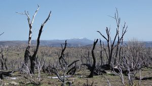
The featured image is a picture of the remains of Four Mile Hut burnt down during fires of Jan 2020
More pictures on Google Photos
Lorna Doone and Duffers Gully Photos
2 – 5 October 2020 – Four & Nine Mile Diggings, Sth & Nth Bloomfield, Lorna Doone (Kiandra Trip 17)
Purposes
The purposes of the trip were to check out the Lorna Doone Mining site and Duffer Gully Diggings which are down a ridgeline to the west of 9Mile Diggings. With any spare time I planned to check out around 9Mile for any hut sites that has become discernible after the Christmas 2020 fires, then to visit South Bloomfield and the Elaine Mine for the same purpose, then repeating this at 4Mile if time prevailed. I also planned to visit Basalt Claim and Giandarra and 12Mile Diggings if possible. However the weather had already truncated the walk to a maximum of 4 Days so none of the latter was possible.
Context and Conditions
I drove around 220Km from Canberra to Kiandra and was only able to park at Pollocks Gully just off the Snowy Mountains Highway. So I started from here late on the morning of Fri 2nd Oct in cool conditions. Initially I could see that both Wolgal Hut near where I had parked and higher Pattinson’s House had both been burned down and were surrounded by a wire protection fence. It was interesting that the fireplace was still standing in Pattinsons
I laboured up the Tabletop Trail. It gave me good views back over the valley below and I could see still a lot of small snows drifts.
Summary of Items of Interest
- I found and GPS’d a race No 13 from G-T’s previous study from its start in Upper Pollocks Gully to her Dam 6 then down to near Township tunnel
- I found some water flowing down to the start of a race on Milkman’s Ck which then goes around into 9Mile valley
- I found numerous hut/tent sites north and west of 9Mile Ck as well as many in Upper Scotts gully and the saddle area between 9Mile valley and Scotts Gully’s valley
- I found another race coming around from somewhere in Milkman’s Ck valley to Dam2 near Gold Hut
- I sorted out the various races going from the main Empress Sluice header dam across to the Upper area of Scott’s Gully
- In South Bloomfield I found three possible hut sites down near the old Elaine access track.
- In 4Mile Ck area I found a hut site near the main sluice header dam
- I also sorted out races coming from Clear Ck area to the main 4Mile Holding dam as well as to the North Bloomfield Sluice header Dam
This trip was one of many over several years checking mining and other historical sites around Kiandra to help historian David Scott and ultimately Kosciuszko Huts Association (KHA) with documenting European historical activities within Kosciuszko National Park (KNP). In the process many hut and mining sites have been found, GPS’d and photographed.
This was a continuation of many previous trips to both 4Mile and 9M Diggings including Tabletop, Broken Dam, Elaine Mine and North & South Bloomfield Areas going back to around 2011.
There is an associated Site List in excel format which was compiled from saving the gpx file as text format and loading into excel. It was heavily edited as I found numerous duplicated entries, some missing which I was able to fix and I added a few more sites from earlier trips and some comment points to give context to the sites.
2nd Oct- Day 1
Day 1 Race 13 to Kiandra. I left my pack near the trail after climbing close to the top of the trail as it flattened out. I then went west for 300m or so to see if I could pick up Race 13 from a report by Gant-Thompson of 2009 about the Mining Landscapes of Kiandra. Amazingly at my first attempt I found the race start point. There was no issue that it was the right point. I followed this for around 850m. Parts of the race were covered with light snow and parts were silted with soft sticky mud. I did around 2.5Km out along the race and back to my pack. I intended to come back later and follow the race down to Kiandra, which I did on Day 4.
Day1 – Race 4Mile Swamp to South Bloomfield Rock Dam. I then continued along the Tabletop Trail and stopped next to 4Mile Ck. After lunch I climbed up the Tabletop Trail to the 2nd 4Mile Crossing. I thought I would try and see if I could find the likely spot for the start of the race that goes around to South Bloomfield’s Rock Dam (I had gps’d the race years ago). I walked to the top of the track and then down over the swamp and found nothing of note. So I cut east across the track and went north and then east until I found the race. It was now easy to follow with the rut mostly filled in with silt washed down from the ridge above. Thus it was like walking along a dirt track except for the odd fallen branch or tree. I ended up back on the Tabletop Trail and followed the alignment across it and to the edge of swamp. It looked like the Tabletop trail and an earlier version of the trail on the west side had disturbed the race start which seems as though it was just west of the trails on the swamp edge.
Day1 – Race Milkman’s Ck to 9M Dam4. I walked onto the last top before one drops down to the 9Mile Ck. I then went west and then down NW to Milkman’s Ck trying to see if I could further work out how water was sent to the start of a race that went from that Creek around to Dam 4 in the 9 Mile area. I found that water was flowing from natural flows down the route to the creek and there were several water filled holes that held water slowing it down, as it flowed down the steep descent. It is still a mystery although it is possible the Milkman’s Ck south tributary was dammed enough for any water in the tributary and coming down the hill would then be able to flow along the race to 9Mile. It’s also possible that part of the edge of the creek had been washed away thus stranding the start of the race. The race is most certainly there. It’s just unclear as to how water got into the start from Milkman’s Ck South and if any water from the Broken Dam Ck race actually was directed down to this race. I thought that maybe David Scott had some alternative solution. David need to see this as it’s quite strange and perplexing. (He did in Trip 19 in late Nov)
I got to 9Mile early but cut across the top to near Dams 2&3 and went onto camp near Gold Hut site for nights 1 & 2. It was not the best place as it was very bare, muddy and there was lots of charcoal ie burnt wood around. However there was lots of running water from Dam 3. I did a quick trip down and across to the saddle area between Nine Mile and Scott’s Gully valleys seeing a couple of likely sites.
3rd Oct- Day 2 Lorna Doone
Day2. I did a return day trip to Lorna Doone. I checked out several sites at the west side of 9Mile on the outward and inbound trip. There were two sites found on the outbound trip to Lorna Doone. These were sites 25 and 26. Site 25 is a large hut site (maybe it was two huts) with dual chimneys and smooth area to south. Site 26 was a pile of rocks close to the obvious route to Lorna Doone. On my return I accidentally came upon a cluster of 4 piles of rocks all close together which all looked like rocks you would expect in a small hut. These are listed as sites 27-30. The area was still grassed somewhat but the rocks were obvious. There was a shovel head on one site. On my return I found another obvious hut site between Dam 7 and the Gold Hut site. Its site 24 and I still wonder why I never saw it before. Its looked dug out a little on its western side thus a sure hut site. It was right next to a race that I tracked on the next trip as coming down from Dam4.
Lorna Doone. On Sat 2nd Oct I had a day trip return from near Gold Hut at 9Mile Diggings down ridgelines to Lorna Doone mining area as well as the Lower Duffers Gully mining along the creek nominally named Duffers Gully.
The route down should have been reasonably easy however I turned south west too early and ended up in the higher sections of Duffers Gully. It was actually easy walking although tempered with some large fallen burnt trees and peppered with lots of tall burnt timber that has to fall at some stage. The creeks and side creeks were all flowing well. I turned more sharply south west and sidled around the ridge until I was in more open country and could pick up a rut coming down the ridgeline from the area I had been earlier. This rut I guess was the earlier old track down. As I headed down this rough route I realised that the rut was finishing and the country was becoming more open. So I tendered to walk more west and headed nominally for the Blacksmith point I had on my GPS. Before getting to where the Blacksmiths site was I came across quite a few dug out areas which all seemed to be wombats, so I turned more southerly and came across several shafts. The first was quite deep at about 4m deep and roughly circular. I continued south and found a shallow shaft and then a 1.5m deep one and then I found an ore skip sitting in an area that was obviously not the main mining area and still some distance above that area. No idea why it was there.
I then went back a little and headed downhill towards the creek, ie in a north-west direction. Going down I came across several small shafts one 2m deep and 2m long. Most were circular although some were rectangular and more like a trench. I continued further downhill. I came across a couple of more shafts roughly 2m and 2.5m in diameter and no more than 1m deep. But below these was a long dug out small gully that went down to the main Creek. From this site I was able to track back up the creek around 70m to find the Blacksmith Hut site GPS 629984 6018703. The location had been levelled and was quite long. The pile of stones being the fireplace was at the north-eastern end of the site.
I then went back to the small gully and continued down the main creek. I tendered to stay at the level I was and thus came across another shaft 3m in diameter and 1m deep with another gully running down to the creek just south of the shaft. I went further south and came across another shaft 3m in diameter again and not very deep. This shaft might be in the spot that is supposed to be a 105ft deep shaft. It was covered by silt or soil which looked wrong for such a shaft. I could also see downhill and the possible tunnel entry area. This shaft was more or less directly above the likely tunnel alignment. I couldn’t see any more likely shafts close by so I went down towards the creek and came to the tunnel entry area.
The tunnel entry area is quite obvious but it’s not clear where the entry is as some of the tunnel inside the entry may have collapsed. David’s photos seem to show a hut on the left side of the actual entry. I could not see this in the entry area. However at the beginning of the entry there is a small area on the left that could have contained a small hut or similar structure.
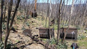
I wandered around and could see the skip in the creek, some rails and the spoil just downstream from the tunnel. The spoil is spread over the ground and not that large leading to the conclusion that maybe the tunnel didn’t go that far into the hill which I assume is backed up by little work having been done and no gold returns documented.
The associated equipment is located downstream from the tunnel around 45m. The equipment is located over an area of length 15-20m with the cluster of Battery Boxes, Camshaft, Iron Battery Stanchions, Trampers located at the north end and the Tangye Engine at the south or bottom end. It’s a level area of width around 5-6m wide. The Stamper Drive Reduction Wheel is located between these two sets of items. The boiler with its large funnel is located to the east or right of the engine and slightly uphill. In this area I did not take GPS reading of each item although I took pictures of most. This was an oversight. However I did walk around all the items and this created a gps track. This has enabled me with all the pictures in creating gps readings for most items. It’s hardly useful to have gps items for some stuff as they are clustered together and also side by side.
For the engine Tangyes is the company name I think. Richard Tangye and his brother owned the company in Birmingham UK.
I also went across the creek but higher up than opposite the machinery, looking for the site of the Managers Hut which for some reason I thought was higher. There are some flattish areas across the creek but much higher and opposite the Blacksmiths area. Lower down the opposite side of the creek is quite steep and fairly green with grass. There didn’t seem to be any flat areas. However I found a very small area on the mine side of the creek just north of the Tunnel and a couple of dug out flat spots just down and above of the boiler and another south and just above the level of the engine. The lower level site might have been the mess hut area and the higher one might have been the managers hut site or any other hut. Looking at David’s pictures on the Lorna Doone InfoShts the Managers Hut seems to be on a hillside that is relatively bare, with some trees. The area opposite the mine is quite green, relatively bare but with few trees lower down. Certainly the Mess room and store would fit onto the site just south of the engine quite readily.
I went south of the machinery area looking for signs of races but ended up walking around the contour and finding a small open cut area with some railway lines slightly downhill of the site. It looked like the line went back to near the engine area. A picture of David’s showing the stamper battery also shows a rail line to its left which lines up with the location this rail would have gone to.
I went further down and looked at the rapids/falls that were roaring in the creek below Lorna Doone as well as to look at the Lower Duffers Gully Diggings which I did. I gps’d these diggings going some 140m along the creek side with some large piles of neatly stacked stones. In between some stone piles there were a couple of flat neat areas that could have accommodated tents or huts. I went below the diggings slightly and could see some minor diggings below. On the way back I went up a ridge slightly to the east and looking back I could clearly see parts of Tumut Ponds.
With respect to races mentioned in David’s document I found no evidence of any races and looking at the country as I did there was no evidence of any creeks close by to the east. Why would they need a race when they had a creek right next to all the main mining activities?
As to Upper Duffers Gully diggings, I didn’t see anything like the stone piles etc of the Lower Area. Looking at the pictures I can see some rock strewn along and in the creek below. However I remember this was fairly minor and somewhere near the junction of side creek joining Duffers Gully.
On the way back I went back through the main mine area and took some higher level pictures which give a better view of the machinery area. I went back up the ridge close to the Blacksmith site and took the route back the way I came down but went mostly straight up the ridge line in a SE direction and then swung around to the north along the ridge, before swinging north and then around to the SE. The area of the top of the first ridge climbing out of Lorna Doone is still populated with very tall burnt timber and I felt it best not hang around this area. Most of the route does not have that many tall trees and is quite negotiable.
I also created a possible gps track to show the best route from 9Mile area (near Gold Hut) to Lorna Doone. It’s very similar to Phil Kendell’s route.
4th Oct – Day 3 at 9 Mile, Bloomfield and Elaine Mine
Initially I re looked at Dams 2 & 3 around 100m north of me. I looked at their linkages and both did get water from that race coming from Milkman’s creek and beyond. Water was flowing down the race into the lower Dam 3 and thence out of the dam and down some races and into the long sluice gully that starts near Gold Hut and goes west for several hundred metres before exiting down to the 9 Mile Ck below it. I also noticed and checked out a spring up the hill at a similar level to Dam2/3 as the spring fed a couple of races that flowed down into the same long sluice just east of the Site 24. I need to review previous sketches of this area, but have only done a rough pencil one thus far.
I spent the rest of the morning looking around 9Mile mostly around the saddle between the two valleys, a little around Dam 19 and upper western part of Scott’s Gully valley, as well as Upper Scott’s Gully area to Tabletop track and Header dam. I also went up the hill to the south west of the saddle and checked to see if there was anything there, which there is not.
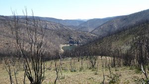
I found a couple of sites near Dam 19 and quite a few along the saddle between the valleys. Many may not be hut sites and just might be fireplaces or locations where miners gathered outside to drink or socialise. There is one strange site on the saddle that has rocks lined up to create an open grassy area. It’s close to the track between the valleys that comes up from the Village area.
In these areas I found sites 33 and 34. The latter is down off the ridgeline and protected from the wind and may only be a fireplace. Nice view of the Empress Sluice from over here.
Around the saddle and edge of the village I gps’d sites 31 and 32 as side by side sites, 35 with some broken glass, 39 and 40, with 39 being an area with heaps of glass and 40 being a pile of hut stones? Close by is Site 36 right on the saddle with more heaps of broken glass. Just down from Site 40 is 41 which is not a hut site as such but a large grassy field with stone edging of various types around most of it. The mind boggles as to its purpose.
Up in the Upper Scott’s Gully I found a shovel head (I didn’t gps it), Site 43 which looks maybe like a shelter site with stone walls around most of it, Site 44 another nice field of grass hidden by piles and wall of stone around it. I looked for a collapsed tunnel for that obvious mullock heap but only found a weak candidate some 60-70m uphill on the side of gully that runs up there.
Up the top sections I found the end of two races near Tabletop Trail that came from Header Dam across the trail and another that comes from edge of the main sluice the along parallel but below the trail to the same location. There is a possible Hut site along there close to the sluiced area Site 42, but is only a large pile of stone next to the race. I need to review my latest sketches of this top area which I think are generically correct but some of the detail might need improving.
I had lunch after this thinking it was all over. Apparently Stefan (de Montis) has found another site near that wooden stove. I then went up the main trail planning to go over the top from the peak on the trail just north of Milkman’s Ck but blow me down I saw another pile of rocks off to the west side around 100m or so up the trail from the 9mile Ck crossing. Site 45. Look s like a hut site to me.
Broken Dam Ck to Milkman’s ck etc race. I walked along the Tabletop Trail to the peak just north of Milkman’s Ck (Note this is an excellent point to climb up onto the range if one wanted to go directly to Broken Dam hut) and climbed up towards the main range on the east. Shortly I struck the race that comes down to Milkman’s Ck from over the top. I followed it up for a while and re GPS’d parts. It reconfirmed my belief that this race that starts at the top of Broken Dam Ck did supply water to 9M; right to Dams 2/3 and possibly Dam 4. On the top, the race becomes faint for around 40-50m. I have marked this on the gps points with ‘Flume starts’ and ‘Flume finishes’. I don’t know if they used a flume or degradation over the years and possibly human travel may have flattened out the race groove. It’s of little consequence as you can pick up the race again on the east side and I have previously followed the race from Broken Dam Ck’s source to this spot. The source is an embankment just under the escarpment from which the creek starts and a race also came out the end of the embankment and around the escarpment.
Bloomfield, Elaine. After leaving the race above, I took a bead on Cairn 4 and then went down towards the Rock Dam. I then struck another race which I crossed before reaching the race that comes from Broken Dam to the South Bloomfield Rock Dam. I don’t know where this race starts or finishes but its parallel on the contours and has to supply 4M or Sth Bloomfield. Where would it start? Maybe Broken Dam Creek also? Note another document I found “AUSTRALIAN ALPS MINING HERITAGE mining-appendixes”. In Appendix 2, there is a SAMPLE HERITAGE ACTION PLAN – SOUTH BLOOMFIELD & ELAINE MINE, page 57 and it has a sketch that shows this extra race above the Rock Dam and its race from Broken Dam. I have extracted it and included it in pictures as jpg image. Note the report also has similar work on 9Mile, 4Mile and NCH, etc. I dont believe the sketch is perfect or to scale. The Bloomfield Header Dam 2 looks misaligned with the Sluice and it’s more a wider and less circular dam. But it does show this extra race. (Note I found the race source and its end point in Kiandra Trip 18).
I continued east below the race and then came to the Broken Dam to Rock Dam race. I then visited and noted the shaft near the race and Rock Dam is nearly full of water. I then went down to the Header Dam 2 (D Scott’s naming, previously my 4M Dam 10) and looked around the area just below its wall. There were quite a lot of rocks strewn around and some small groups. I thought maybe a fireplace or two more likely than a hut site. However I took a couple of waypoints. I went further down and thought there was a fireplace close to the sluice edge around halfway down. I continued down to near the bottom of the sluice and found several sites that looked like possible hut sites. I took pictures of three with a couple of pictures of one site. These were close to David’s Sluice Huts Point on his original maps for the area. There was some broken glass located at one of the sites. The area here is quite spacious and fairly flat for the sites in question. They are close to the track that went around to 4Mile. I then went down to Elaine taking some time to work out the old track versus the Bloomfield Race. At Elaine the tunnel is still open and it’s quite full of water. There was a strong flow coming out from under the soil in front of the entrance area. I had a good look at the mullock heap and can say it is fairly straight with minimal spreading at the far end. The creek was flowing strongly and deviated out and around the heap.
I then went on the old trail across to 4Mile Main Sluice top. However it was not as easy as I thought it would be as the trail is not as obvious as it could be but the main impediment was the quantity and size of fallen burnt trees. Both creek gullies that the old trail negotiated were damaged by huge fallen trees and I had to walk carefully around them. It popped into my mind that the route would make a great walking route and even better if it was continued up to Broken Dam Hut. A nice walk from Selwyn or Kiandra to 4Mile Hut area, across to the Main Sluice, then across that track to Elaine, South Bloomfield to Broken Dam Hut and then back along the Tabletop Track to 9Mile and the start point. Not sure NPWS has the enthusiasm to agree with such a scheme.
4Mile Area. After leaving 9M area and walking over the range checking out some of the Broken Dam Ck to Milkman’s ck etc race I walked around on the old trail to the 4Mile main sluice and Header dam. Here I immediately found the 4Mile Hut Site1 just above the top of the Sluice. David has it as 4Mile Hut #4. It was getting late so I went down towards Glennie’s Hut area which looks in good condition as does the nearby Dam 7. I also visited again Hut sites Sluice Hut A and B and looked for David’s Sluice Hut C. Even with the GPS I couldn’t find it although I walked to Dam6 and all around. I don’t know what that means. I also went to the old 4Mile Hut site and camped there for the night. It was a cold windy night and the old site had some metal pieces that banged a little all night. The area is not so bad with lots of grass although the area to the west is heavily burnt out and it’s hard to see the track up to the Tabletop track.
Note: On a later walk at the end of Nov David and I looked for Sluice Hut C and couldn’t find it at the coordinates I had had. I think it’s been scratched.
5th Oct – Day 4 Re-examination Clear Ck to North Bloomfield and 4Mile Main Dam Races, Nth Bloomfield & Race 13 Again
I wanted to show David Scott the complexity and strangeness of water coming out of the ground. So walking up from 4Mile Hut to the Tabletop Trail I was able finally to see where one race crossed the access trail to 4Mile Hut area and gps’d it. I then went across to near where Yan’s Slip rails had been and dropped my pack near there. Those slip rails are no longer with only a couple of nearly burnt out posts remaining. One race had actually come very close to the rails before turning and heading across the main trail. You can still see the turn but the race disappears as it heads across the main trail.
So I headed off pack less; a great feeling! I followed the line off the race as it headed off north-west to what I believed was the start point around 640m away. I trudged along part of the race and next to it and further away when having to walk around fallen burnt dead trees. I noted a few small streams coming down from the hill to the north joining and crossing and even leaving the race as they wound their way down to Clear creek to the south-west. Close to the target point, I knew the other race coming down from Clear Ck tributary just below the Selwyn track, passed close ie 1m away from the race I was following. Now that all the low scrub had been burnt away it was easier to see. Then I saw the race I was following turn right and cross another race. This was not the way I had seen it or gps’d it previously. These two races had always been a pain in the arse as they were covered with heavy and strange scrub and both did weird things. Both crossed the Tabletop Race and both took water from Clear Ck tributaries (ie Murray Basin) across to North Bloomfield and Four Mile Dams (both in the Snowy Catchment).
Now it looked like the race from the Ck near Mt Selwyn track went across the other and took water to the Main 4Mile Dam, whilst the smaller little creek just west of here took water to North Bloomfield Header Dam. Crikey I had given David bum steer. It took me by surprise as well. I turned left and followed that race 100m+ to where it started, right where a small creek was coming down from a bare saddle above. I re gps’d the start point and wandered up the creek. Actually the creek broke into two as it came down and I am unsure if the race picked up water from both as they are close. 75m up the short hill the creek came out of rocks or boulders. That’s always strange to see. I continued up to near the top where it opens out into a wide open valley. In about 70m I was at another strange spot where there was a flow of water coming down the valley and then entering into small group of boulders and going underground. That’s was enough. So it went underground and further down it came out again as small creek. I turned and went across and picked up the other race that came out from the same valley above but slightly higher up to the east. I followed this down until I came to that spot where it now looks like the races crossed over. The race I was now on actually did come downhill and thus the water must have run faster and I think it would have been impossible to do a 90 degree turn rather than cross the other race and do a gentler turn and flow down to the Four Mile Main Dam.
So I think the reality is now: The Clear Ck tributary flows over that large open valley and comes down and past Yan’s Slip Rails and onto the 4Mile Main Dam and is about 2.7km long. The other race comes from a Clear Ck tributary also but from a strange takeon setup around to North Bloomfield Header Dam is only now 775m long. Looking at my photos I noted a small pile of rocks just north-east of the race start. Might have been a hut site there. I have created a new list of waypoints and a gpx files that shows the two races updated from this walks details, i.e.: 4Mile Races to Main Dam and NthBLM Header Dam Updated 2020.xlsx; and 4Mile Races to Main Dam NthBLM Header Dam Updated Oct20.gpx.
Day 4. – North Bloomfield. I went up Tabletop Trail to North Bloomfield and dropped my pack again and wandered along the main header race noting some features David has documented. I still believe the race does go all the way to Commissioners Gully area. However there is a big hole in the race now, a wash away from a small stone creek that comes down from the large granite boulders area up the hill. It’s quite a big hole really and it was not there is the past. I could see where the header race had one or more outlets to a subsidiary race that runs parallel to the header race for some distance and is probably the main conduit for water to get to the main sluice gully below. I also went down the north side of the gully and visited a couple of definite hut sites, as well as revisiting the tunnel some 100m away. It’s clear to me now that the tunnel skips could have gone on a rail line and along the mullock heap. I also saw the Mine Hut that David found near here. However I could not find the Blacksmith’s Hut, or Mine Hut that is supposed to be inside the main gully. I also could not see any evidence of a tunnel on the north wall of the sluice gully although the spoil heap in the middle suggests it was there. I am not sure David’s engine GPS is correct.
Race 13 to Kiandra. On Day1, I had walked out along the Tabletop Trail. I had left my pack near the trail after climbing close to the top of the trail as it flattened out. I then went west for 300m or so to see if I could pick up Race 13 from a report by Gant-Thompson of 2009 about the Mining Landscapes of Kiandra. Amazingly at my first attempt I found the race start point. There was no issue that was the right point. I followed this for around for around 850m. Parts of the race were covered with light snow and parts were silted with soft sticky mud.
Now on Day 4 I returned but this time carrying my pack, and to walk from where I had left the race and follow it down to Township Hill Tunnel. So I keep walking and taking sample GPS points as I went, trying to take them on bends or corners. I came to Dam 6 and GPS’d the entry and exit points. The exit is on the NW corner where it has a partial stone wall. However a lot of it is earthen wall. It quite large overall. I continued down and came to a spot where there is an obvious hut site around 250m along the race just on the NW side of the race. There were great views over NCH from this spot. Unfortunately the weather was deteriorating and my pics look slightly strange through late sunshine and some dust in the air.
Further on I came to two more obvious sites although I think they were more stone shelters. The race had turned more easterly and near these two sites it started to drop dramatically. I marked a race point as being Vertical which it was not; but it was damn steep. Carrying a backpack I had to take it very carefully. After dropping down I started to lose the race as a creek developed and new races started I thought. I didn’t have time to check it out. I did find the grill that covers the Township Hill Tunnel air shaft. Soon I was back at Pollocks Gully and it started to spit rain.
Distances
I did about 58Km including the Lorna Doone trip.
Diagrams, Pictures and Docs Available
Pictures are in two albums in original full quality in Google photos. These have captions available see the ‘i’ button. The album is shared but only for those with the link.
Documents.
Note that all documents ie word docx, excel xlsx, gpx, txt, gdb (Garmin old files) are available on Google Drive and several sub folders
GPS GPX Files – There are three gpx files:
- Kiandra 17 Oct 2020.gpx which covers all my trip as well as Lorna Doone
- Best Route to Lorna Doone from 9Mile 17Oct 2020.gpx
- 4Mile Races to Main Dam & NthBLM Header Dam Updated Oct20.gpx, which only covers those two races from Clear Ck etc to Nth Bloomfield Header dam and the Main Four Mile Dam.
Sketches
LD only Sketch from Mining Remains NthKNP_Pearson1979.jpg This is extracted from an external report showing Pearson’s layout of key Lorna Doone items
2020-10-17 Races West of TabletopTk to 4Mile LargeDam & NBlm HdrDam Sketch in both jpg and pdf format
AUSTRALIAN ALPS MINING HERITAGE mining-appendixes Elaine Sth Blfld Map jpg. One page extracted to show South Bloomfield Elaine items and extra race I stumbled on.
Excel Files -There are several xlsx files:
- Kiandra 17 Oct 2020 Sites without Lorna Doone.xlsx – This covers nearly all areas, 9mile, 4Mile, North and South Bloomfield, Race 13 to Kiandra, and races from Clear Ck to NBLM and 4M Main Dam
- Kiandra 17 Oct 2020 Sites Lorna Doone only.xlsx – This covers all Lorna Doone sites
- 4Mile Races to Main Dam and NthBLM Header Dam Updated 2020.xlsx – This just covers points on these two races
Post Categories: Kosciuszko NP, Kiandra Walks, Mining, Mountains, NSW, Huts, AAWT
Post Tags: Tabletop Trail, Pollocks Gully, Wolgal Hut, Pattinson’s Hut, Four Mile Hut, Gold Hut site, North Bloomfield, South Bloomfield, 4 Mile Diggings, 9 Mile Diggings, Lorna Doone Mine, Duffers Gully Diggings, Elaine Mine, South Bloomfield Rock Dam, Scott’s Gully, Upper Scott’s Gully, 4 Mile Creek. 9Mile Creek, Empress Sluice, 4Mile Sluice, 4M Sluice B
Relevant Topographic Maps
The NSW topographic maps covering the area of this trip are:
1:25,0000 newer maps:- Cabramurra for 4Mile, 9Mile, Kiandra Pollocks Gully
I strongly recommend that keen walkers check out the use of Oziexplorer from Des Newman’s OziExplorer plus OzRaster from GPSOz
Use of Oziexplorer with OzRaster maps for NSW enables you to load up a gpx file and see your route (and one’s available off this trip) on a modern topo map base. You can run Oziexplorer on Tablets and even Android devices
Happy exploring. 4 & 9Mile Diggings are some of the most interesting sites outside New Chum Hill at Kiandra
Greg Hutchison, 16 Oct 2020 Updated Jan 2021


