2019 06 20 Square Rock Namadgi with Melba Shed
This was Melba Shed’s 2nd visit to Square Rock. This was a nice walk on a standard bush trail providing views out over the Brindabella Ranges and also some views along the length of the Orroral Valley. This was a Melba Shed walk No 207.
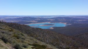
Featured image is view of the Brindabella Ranges from Square Rock
8 of us met at the Shed by 8AM, then drove in 2 cars to Corin Forest. Access was through Tuggeranong ie Woodcock Drive, then to Point Hut Road then right on Tidbinbilla Road, turning left at Corin Road towards Corin Forest.
We then parked at the Corin Forest Hub Car Park on the left just past Corin Forest. We then walked up to Square Rock leaving at 9.32AM. This was about a 220m overall climb. The trip was on a nicely made track with reasonable gradient. There are some metal ladders to climb at the Rock but its only 3 metres or so and safe. We then returned & went out to the Orroral Valley Lookout and stopped there for some lunch. We returned to the cars by 1.14PM, thus taking 3Hrs 42m including breaks.
The car park was at about 1210m & Square Rock is about 1375m although on the way there & back we passed through 1425m.
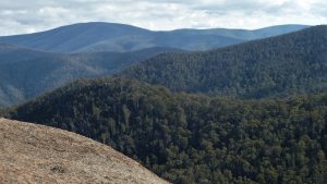
Scenery from Square Rock is superb with views from Mt Gingera to Mt Franklin being possible although each peak is hard to discern.
Medium Walk. Total 10.5Km, including visit to Orroral Valley Lookout. The car distance was about 60Km each way, total 120km trip. It took close to 1.5 hrs to drive there.
On the way back we stopped in Tuggeranong at a nice small cafe, the BrewBar on the cnr of Athlon Dr & Reed St Nth.
The weather was crisp and very sunny. But the day started around-4C at Melba and climbed up to around 8C at Corin Forest. Some frost was around early on.
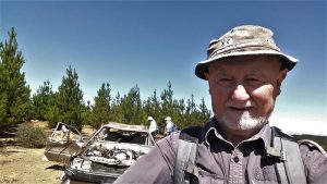
Walkers: Bob Salmond, Colin Fitzpatrick, Geoff Grimmett, John Edge, Paul Taylor, Drew McDonald, Tony Weir, Greg Hutchison.
Drivers: Fitz & Greg H
Map of the walk | More pictures in Google Photos | gps, gpx and GE files are located in Google Drive
Notes: GPS map view using Mapsource on a map base using OSM NSW Garmin Cycling Map and using Oziexplorer on a map base using OzRaster NSW topo Map with permission of © BKK Enterprises Pty Ltd. | The area of the walk is covered by the NSW 1:25,000 topo map CORIN DAM.
Previous Visits: 2012 08 20 – Visit to Square Rock in the Snow – pictures | 2013 04 25 Visit to Square Rock with Melba Shed – 1st Visit – pictures