2018 08 09 Kowen Trail Runs – Greenways – Goorooyaroo
Three walks total 15.1Km. The first I walked most of the Kowen Trail Runs, then walked a section of the Greenways near Bywong Community Centre, finally found access point to Goorooyaroo NR in NSW and did a small sample
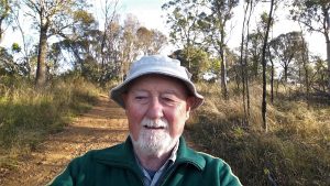
Featured image is Greg climbing Poppet Hill on the Fenceline Trail, Kowen Forest Runs
On this date I did three walks:
- Kowen Trail Runs – 8.6km
- Greenways (section) – 4.0km
- Goorooyaroo NR (NSW) – 2.5km
What was the point of these walks. Well they were all in a similar area, that is just North East of the ACT, east of the Federal Highway and west of escarpment overlooking Lake George and Bungendore. It contains an area of generally 800m altitude, a large variety of small farms and several nature or forest reserves.
This started one weekend a month or so ago when I saw a post on facebook about Kowen Trail Run. This is an event they run twice a year and over any of 12km, half marathon or a full marathon distance. The events starts in Wamboin at the Community Centre along Bingley Way. They then have to run along the road for 1Km or so then up a dirt crown road into a NSW Crown Forest Reserve along a formed trail and into the ACT and around various parts of the north west section of Kowen Forest. Its an active pine plantation forest in the north east section of the ACT.
This time I wished to walk the Kowen Trail Runs in one go.
I drove 40km on a cold and foggy autumn from Belconnen, Canberra out to Bingley Way and parked at the spot where it said 242-244. Then I walked up the Crown Road, turned left and found the turnoff labelled Boundary Trail. I took this trail all the way out to the Fenceline Trail which is next to the ACT border and a boundary road that runs within Kowen Forest over the border. On the way I saw an old feint track turning off the trail and followed across until it reached another current trail. This latter Trail was the CSIRO trail. I returned and finished the Boundary Trail. On the Fenceline trail I came across a Calavetti (ie horse bars that form a gate for most stock but which horse can cross). It was opposite where the CSIRO Trail leaves the Fenceline Trail and very close to where the Saddle Trail also finishes. The Fenceline Trail continued running close to the fenceline and soon it passed another junction, where another short trail runs along ridgeline to join the Saddle Track. I continued along the Fenceline trail until it climbed up to Poppet Hill, the last part being more of a feint footpad. At the top I enjoyed some more good views south and west across the the ACT. I then continued along the fenceline, passing the junction where the Gold Rush Trail finished. I ended up in another 100m reaching a gate on the border that serviced a 4WD trail that came up the direction of Norton Rd.

So I turned around and went back to the Gold Rush Trail and took it back to the Saddle Trail. Near where I had joined the Gold Rush Trail I went down hill a little and found a large dam just below the ridgeline. I followed the Gold Rush Trail back to the Saddle Trail and then followed it back to the Fenceline Trail until I could join the CSIRO Trail following it right through its numerous twists and turns back to the Saddle Trail. The CSIRO trail turned out to have some history to it, as apparently the CSIRO had run some experiments in the area in 1975. There is a sign to that and also quite a few metal signs on starpickets notating various sites. I noted sign numbers 12, 13, 15, 16, 30, 46. There was a metal barrier across the small creek near where there was an old small slab. Back on the Saddle Trail I easily returned to the Crown Road and the car. So I had done all the Trail Runs Trails except for a small portion of the Saddle Trail and a little extra on the Boundary Trail and Fenceline Trail.
Overall I did 8.6Km. It will be slightly less for the whole leaving off my side trips. I started walking at 8.42AM and finished at 11.16AM.
Greenway
I then drove up to Norton Rd, then Weeroona Drive until I got to the junction with Denley Drive. I then parked around the corner on Denley Drive and proceeded to try and find the points where the Greenways join and leave from this area. The Greenway that goes south, Track 3 was easy to find and the one east to Woolshed Lane also easy but I struggled to find the one for Track1 which went up to the Community Centre and also out to the west. After some rechecking I found it just across the road and close to a pine plantation. I went up along this and came to a junction with the link to the Community Centre going right and the link West went straight ahead and up and over a little saddle, then down until it did a short dog leg near where it linked to Harriot Road. I could see some tape markers on the south side which I deduced where the markers for a future Greenways route south to Birchman’s Grove and further. I was a little tired and as I had achieved what I wanted to went back to the car.
Goorooyaroo NR
I then drove back down Weeroona Drive, to Nortons Road, then along it to the Yass Road and took it for another 1.3Km before turning left onto Goorooyaroo Lane. I then went through a muddy puddle across Amungula Ck and continued along the Lane until it reached a dead end which continued into a farm. As I turned around the man who lived there returned and I had a quick chat to him learning that it was possible to park along the road and walk up to the border. Apparently he had lived there more than 60 years and regularly walked in Goorooyaroo Nature Reserve. He indicated that the authorities had a vague idea that the air force had dropped bombs in there more than 60 years ago thus they had put up signs telling people not to walk there. So I parked the car and walked around in there for 2.5Km. I would have gone further except my right leg high on my thigh was hurting quite a lot and I was finding it hard to walk. I had no idea what I had done. I got back to the car and didn’t get home tell around 3PM.
The track I had followed went along the boundary fence in a northerly direction and I left it only part way as it climbed. I suspect it continued to climb and probably went more west to the border.
Afterwork & Thoughts
I have examined all the data collected and also gone into Google Earth and the Sutton NSW topo map using the Ozraster digital version to better define some access points and Greenways along some obvious crown reserves. Also the Bywong and Wamboin Community website offers some more hints. A walk they did on 26th Jan 2016 shows a Greenway route that is not on their published brochure. So are I have only walked a small section of the Greenways but we have GPS the ends of most of the trail section. Its work in progress to better define and check some section with a gps
The Kowen Trails Runs have all been walked and gps’d. It just needs a little cleanup to finalise the individual Trails
Goorooyaroo NR in NSW needs more research and checking on the viability of having walks there.
Map extracts and gps files
Map of Kowen Trail Runs | More pictures in Google Photos | Google Earth GPS file
Notes: GPS map view on map base using OSM cycle map &/or Ozraster Map with permission of © BKK Enterprises Pty Ltd, http://www.gpsoz.com.au | gps, gpx and GE files are located in Google Drive