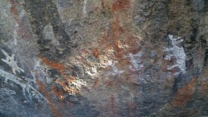
2018 07 05 Yankee Hat Rock Art & Middle Ck with MelbaShed
A traditional walk to the Aboriginal paintings at the Yankee hat Rock Art site in Namadgi National Park, ACT. The walk is a relatively easy one of 3km out to the paintings. However we continued on tracking north west around the open woodland on the lower slopes of Mt Yankee Hat until we dropped in the Middle Creek valley picking up an old 4WD trail that took us most of the way to the first major junction where middle creek splits into two higher tributaries. This was a Melba Shed walk
Featured image is of Greg on the bridge that crosses the small Bogong Creek
5 of us met at the Shed by 8AM & drove to Yankee Hat Car Park off Boboyan Rd, along the old dirt Boboyan Road. This was by way Tharwa and down the main Boboyan Road. From around 9.40AM we walked out to the Rock Art site along a well maintained walking track. Of course along the way we saw numerous roos. Millions really. The whole valley is covered with mobs of roos, many very young. Then after viewing the paintings we continued through mostly open forest down to Middle Ck. Then we continued up a 4WD trail to where Middle Ck splits into two Cks. Here we got bogged in some horrible thick scrub near the junction before returning alongside the creek but on the other side. Here we found the Middle Creek aboriginal Rock overhang site. We then wandered down both sides of Middle Ck until we returned to the 4WD track taking it east until we could view the cascades & some aboriginal grinding grooves. After a short lunch break we visited Ruskin’s Hut site ruin & then we returned back along tracks to the car park by 2.18PM & we were home by 3.50PM. On the walk we had views up Middle Creek of mountains behind to the west and the NSW border.

Overall we took 3hr 38mins on the walk including breaks. We walked at an easy pace. Medium Walk. 12.1km.
Altitudes: The Car Park Alt was 1020m, Yankee Hat Rock Art was 1070m, Gudgenby River crossing 895m, Middle Cks Jn 1030m.
Car distance: It was 155km return from Melba.
Walkers: Drew McDonald, John Edge, John Marsh, Neville Viney, Greg Hutchison Drivers: Neville Viney, Greg Hutchison
Information
Jack Rustins Hut: Records state the site is marked by chimney stones & other materials. An unmarked grave is known to exist close to the site. Some of the materials from the hut may have been used in the extension of the Gudgenby Homestead kitchen late in the 1920s.
The Mountains North West Up Middle Ck: On the track from the car park to the bridge over Bogong Creek we could see 3-4 well defined high peaks well off to the north west along Middle Ck. These were a lot further than we thought. These were Mt Kelly, a knoll on the Burbidge spur, Mt Burbidge & Mt Namadgi. The three peaks to the left in the foreground are Mt Gudgenby, Yankee Hat South, Yankee Hat North. Mt Kelly is on the border with the NSW. Mt Kelly is the 4th highest peak in the ACT at 1,829m
Map of walk | More pictures in Google Photos | Google Earth GPS file
Notes: GPS map view on map base using Ozraster Map with permission of © BKK Enterprises Pty Ltd, http://www.gpsoz.com.au | gps, gpx and GE files are located in Google Drive


