2018 06 26 Wamboin Greenways Recce
A short walk of 1.6Km along a Crown Road to the Forest Reserve south of Wamboin and adjacent to Kowen Forest as well as a drive around Bywong Wamboin checking out access points on the Greenways tracks around this area. This was done with Drew to check out suitable walks for Melba Shed into the future. I think 3-4 possible walks will come out of this
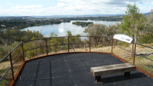
Featured image is of Track 3 Access at 65 Weeroona Dr, Wamboin
This started one weekend a month or so ago when I saw a post on facebook about Kowen Trail Run. This is an event they run twice a year and over any of 12km, half marathon or a full marathon distance. The events starts in Wamboin at the Community Centre along Bingley Way. They then have to run along the road for 1Km or so then up a dirt crown road into a NSW Crown Forest Reserve along a formed trail and into the ACT and around various parts of the north west section of Kowen Forest. Its an active pine plantation forest in the north east section of the ACT.
Once I looked at their website I eventually clicked on the menu item Greenways which led me to the Bywong-Wamboin Community website and their relevant information on their Greenways project. There they have a pdf map showing all the existing Greenway tracks with information on access points with some pictures of the accesses. I was also intrigued about the Crown Forest which abuts Kowen Forest on its north side. It seems it was developed by the trail runners with a range of unique running tracks.
Initially I got hold of the gpx tracks that showed the three Trail Run courses that accessed through the Crown Forest Reserve from Bingley Way. I then did a desktop design of a suitable 10-12km walk starting on Bingley Way and going through the forest and around some of the 12Km Trail Run in Kowen.
After further looking through the Greenways documentation I realised that we could probably devise a walk or two in the Greenways section that would be suitable for old guys in Melba Shed and which would be easier and less hilly than Kowen Forest.
Thus on 26th June I went with Drew, our Assistant Walks Co-ordindator, out to Wamboin to get a feel for what was possible and the check out the accesses and parking options. We started on Bingley Way where we found the Crown Road (Red Track) at the junction on 242-244 Bingley Way and we went up to the first junction where we then followed the saddle Track (White Track) up onto a ridge line until we came to its junction with the CSIRO Track (Green Track). The CSIRO Track looks interesting as it goes down into a well defined gully and obviously comes out again after twisting around the gully. The Saddle Track seems to be the main track for direct access into Kowen.
We didn’t go any further as we had to get back and look at the Greenways tracks. On the way back we deviated on to an old 4WD that took us straight down and on the eastern side of the Crown Road. There was also a small side footpad to the west of the Crown Road that runs down parallel to the road from its junction with the Saddle track. I am unsure if this is on private land. On the way up and down we met two different ladies and they told us a little about the area and some options as well as the Sutton Bakery being the most sensible local place for coffee and snacks. After visiting it after we finished, I have to concur.
This part of the recce took from 10.37AM to 11.16AM.
We then drove up to Norton Rd, then Weeroona Rd stopping and taking pictures and gps entries for any of the accesses to the Greenways we came across. We then went north onto Macs Reef Road and along Birriwa Drive to the Bywong Community Hall and recreation grounds. Drew went looking for the start of Track 1 and found it at a gate behind the horse jumps and small dam. We didn’t gps it but I was able to pick it out on Google Earth latter. We missed a few accesses, especially the start of tracks 2 and 3 but could again pick them up on Google Earth.

We then went to the Sutton Bakery which is a new brick cafe and bakery as well as serving coffee and a variety of exotic pies, quiches, pastries & small cakes.
Observations
We talked about what we had seen and could see that the Greenways could provide couple of circular type walks using some of the local roads as links. Most of the roads had very wide grassy verges. We could also see that the Crown Forest preserve and adjacent Kowen Forest offers several walk possibilities from Bingley Way or even off the Sutton Road where there are a couple of entrances
Afterwork
I have examined all the data collected and also gone into Google Earth and the Sutton NSW topo map using the Ozraster digital version to better define some access points and Greenways along some obvious crown reserves. Also the Bywong and Wamboin Community website offers some more hints. A walk they did on 26th Jan 2016 shows a Greenway route that is not on their published brochure
Greenways options map extracts and gps files
Map of Greenway walk options | More pictures in Google Photos | Google Earth GPS file of Greenway track options
Notes: GPS map view on map base using OSM cycle map &/or Ozraster Map with permission of © BKK Enterprises Pty Ltd, http://www.gpsoz.com.au | gps, gpx and GE files are located in Google Drive