2018 06 21 Tuggeranong Pines & Railway Siding with MelbaShed
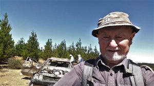
I led this walk, with 7 of us walking. We drove to a parking spot along the Monaro Highway. Then we walked along Forest trails and Mountain bike trails to the Tuggeranong Railway Siding just off the Old Tuggeranong Road with views out over properties such as Melrose Valley Homestead. This was a MelbaShed walk
Featured image shows Greg & Drew in a Railway Cutting near the Tuggeranong Siding
A walk from the Paintball Centre on the Old Tuggeranong Road through some of the Tuggeranong Pines to the Tuggeranong Railway Siding then along the railway north to a large embankment over a gully and creek opposite Gilmore
7 walked. 7 of us met at the Shed by 8.30AM and drove in 2 cars to a car park on the left hand side of the Monaro Highway, exactly 3.2Km from the Isabella Drive turnoff. It was labelled Old Tuggeranong Road. We parked adjacent to the Paintball centre.
From 9.22AM we then walked alongside the Paintball Centre & Old Tuggeranong Rd for 80m, then turn left & took an east-west forest road up a steepish hill, then right through the Pines until we reached a spot close to the railway taking a short footpad to the railway, then south along road adjacent to the line until reaching the siding with platform, points etc. We were intrigued by some of the dates on the railway lines and metal sleepers. Some of the old lines dated from 1886 whereas some newer metal sleepers seemed from 2004 & 2005 guessing just before they stopped any trips to Royalla or Michelago due to unsafe wooden bridges. In some of the cuttings trees have encroached on the railway line prohibiting any trains.
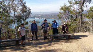
We then headed north along the railway line through a deep cutting for about 500m before continuing on the path beside the line and then the line again until reaching a bridge & causeway after which another cutting can be seen. We then detoured to the east through a fence to view an area where people had camped & even left there a large bra behind hanging on a fallen branch.

We then took a footpad west & down to a track that runs along the railway route & under a powerline. Finally we turned down a path to an Icon water tank & then a trail south to join the original trail back to the cars at 11.18AM.
We stopped at the Chifley Grocer for coffee & snacks after the walk.
Overall we walked for just under 2hrs. It was a Easy-Medium walk, distance of 5.2Km, mostly on dirt foredtry & some dirt foot pads, a dirt road. We also walked on some sections of the railway.
Walkers: Bob Salmond, Drew McDonald, Ian de Plater, John Marsh, Peter Coppin, Roger Amos, Greg Hutchison
Drivers: Ian de Plater, Peter Coppin
Topographic Map: Tuggeranong 1:25000
Map of walk | More pictures in Google Photos | Google Earth GPS file
Notes: GPS map view using Oztopo map base & gps, gpx and GE files are located in Google Drive
References: Canberra Tracks on Railway Border | Dave’s blog post on Tugg Siding | Weekend Notes on Railway Border | Rail stuff | Very interesting history on ACTs early railways | Wikipedia on the Bombala Line