2017 06 22 Palmerville Percival Gold Creek
A 11.2Km walk with Drew to check out options for a walk by Melba Shed guys from Palmerville Historic park to Percival Hill, then to Gold Creek for coffee then returning along the Canberra Centennial Trail (CCT) to Palmerville. We did some exploration of Palmerville and Percival Hill looking for interesting routes, views and historic sites. We think we will keep the walk below 10Km but visit some Gold Creek sites, the child grave on Percival and stick to the signs at Palmerville
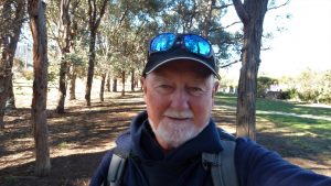
Featured Image is a photo of Drew and Greg
I met Drew at the car park for Palmerville Historic Park just off Owen Dixon Drive opposite the McKellar Soccer Club, McKellar, ACT at 8.30AM. We did just under a 4 hr walk up through Palmerville, then to Percival Hill, thence to Gold Creek for coffee returning back over Percival Hill and down the CCT walking track to the car park.
Some photos of the signs at Palmerville can be seen on the Google Photos album linked below. It gives an overview of the timescale and persons who lived at Palmerville in the early days of 1828 until at least 1905 with the last resident leaving in 1959 when the CSIRO acquired the land. The CSIRO still owns a large tract of land to the west which it plans to release as housing in the future.
We walked through this area following the main path which provides an overview of some of the old sites as well as some very large English oaks that grace the north end of the park.

We then walked along the fenceline north until we reached the approx location of the old PO and store before walking under the large Barton Highway junction above and along the edge of Ginninderra Creek, before going through a break in a fence and walking an old trail up to the top of Percival Hill. It offers great views south to Belconnen, west over Gold Creek and Nicholls and north to Gungahlin Town Centre.
We then went north a short distance before heading down and along a nice forest trail passing numerous roos who were reluctant to move away too far from their idyllic location. We then turned to the NW and followed the ridgeline back to where we had come from, but then turned west and followed another trail down to an optional parking spot at Schow Place, Nicholls.
We then turned SW and followed trail near the Golf Course fence until we found a pole and walked free range looking for an old grave site that we found. According to Richard Poon who had found it years ago it was probably the site of a child grave from some time past. We then back tracked slightly and followed a trail around the edge of the golf course pond, past the edge of the Promontory Estate and then along a road to Gold Creek’s Ginninderra Village. We had coffee compliments of Drew at the Thumper & Miss Bunny Specialty Coffee shop adjacent to the famous Green Herring restaurant.
We returned along the road, then took the offical CCT past Deasland historic homestead and the Backsmith Shop along the edge of the Barton Highway, then up a trail to the top of Percival again then down free range over open ground until we picked up a trail not far from the fence we had gone through earlier. It was a simple matter to reach the CCT along the Barton Highway, then track around the intersection before dropping down a link track and picking up the Gungahlin to Belconnen bike path which we followed until it went under the road. Instead we thought we would be smart by walking down the road for several hundred metres but we came a cropper when the road went over Ginninderra Creek but the bike and walking track were not on the east side whilst we were on the west side of the bridge. However we managed to walk along a thin slab of concrete that extended under the railing and we were able to cross the creek holding onto the guard rail as we progressed. Not the smartest thing to do. Then we were back at the car park.
We saw several Yellow-Tailed Black Cockatoos feasting on wattle seeds on trees on top of Percival Hill. These seem to be around much more lately. However they are not as raucous as the Yellow tailed devils.
Map of walk (Note the map is hard to view online. Download and zoom in) | Google Photos | GPS Files in Google Drive | Blue Line on the Map of the walk is 11.2Km – GPS map view on map base using open source Open Street Maps (OSM) NSW Cycle garmin map